DocumentsStaff ReportJul 18, 2016Pages 38–46
Staff Report — Z15-0028 (Application for 1431 Grand Forest Cl — Bear Mountain Area 6 density)
Planning staff report assessing a request to increase or remove maximum density restrictions for Area 6 of CD6 (Bear Mountain) at 1431 Grand Forest Cl, to permit additional single-family lots and to reduce required preserved open space to a minimum of 40%; outlines background, OCP policy, environmental and servicing considerations and options.
Key facts
- Applicant: Jared Steingard, Westbrook Consulting (on behalf of Lawrence Paul Goudy & Kirsten Elizabeth Peters)
- Subject property size: approx. 77,741 m²
- Proposal: amend CD6 Zone to allow up to 25 lots (or remove the numerical cap), with minimum 40% preserved open space
- Amenity contribution proposed in exchange: $7,500 for every lot created in excess of 15
- Existing constraints: environmental development permit areas, BC Hydro capacity considerations, requirement for updated stormwater management and frontage improvements
Staff Report — Z15-0028 (Application for 1431 Grand Forest Cl — Bear Mountain Area 6 density)
Date: February 22, 2016
Department: Planning
Application No.: Z15-0028
Subject
Application to amend the maximum density permitted in Area 6 of the CD6 (Comprehensive Development 6 – Bear Mountain) Zone from 15 to 25 for 1431 Grand Forest Cl
PURPOSE
Jared Steingard of Westbrook Consulting has applied on behalf of Lawrence Paul Goudy and Kirsten Elizabeth Peters to amend the maximum density permitted in Area 6 of the CD6 (Comprehensive Development 6 – Bear Mountain) Zone from 15 to 25 one-family residential lots, and to reduce the open space preservation area from 55% of Area 6 to no less than 40%.
BACKGROUND
Previous Applications
- On July 18th, 2005, Council adopted Bylaw № 944, which rezoned the property at 999 and 1000 Gade Road from GB1 (Greenbelt 1) to the CD6 (Comprehensive Development 6 – Bear Mountain) Zone and increased the overall density of development in the CD6 (Comprehensive Development 6 – Bear Mountain) Zone to a total of 2983 dwelling units.
- On August 21, 2006 Council adopted Bylaw № 1027 (an OCP amendment Bylaw), which amended Appendix ‘M’ (Bear Mountain Estates Area Plan) of the OCP by amending the distribution of land uses within the Land Use Concept Plan.
- On October 2nd, 2006 Council adopted Bylaw № 1028 (a zoning bylaw amendment), which amended the CD6 (Comprehensive Development 6 – Bear Mountain) Zone by increasing the maximum permitted residential density to a total of 5000 dwelling units and inserting new amenity requirements, additional permitted uses, subdivision requirements, and setback / height provisions.
- On November 2nd, 2009, Council adopted Bylaw № 1254, which created a new Area 6 within the CD6 (Comprehensive Development 6 – Bear Mountain) Zone for 2510 Echo Valley Drive in order to implement the applicant’s proposal to limit development potential of this property to 15 one-family residential lots and to preserve approximately 55% of the property as natural open space.
SITE DATA
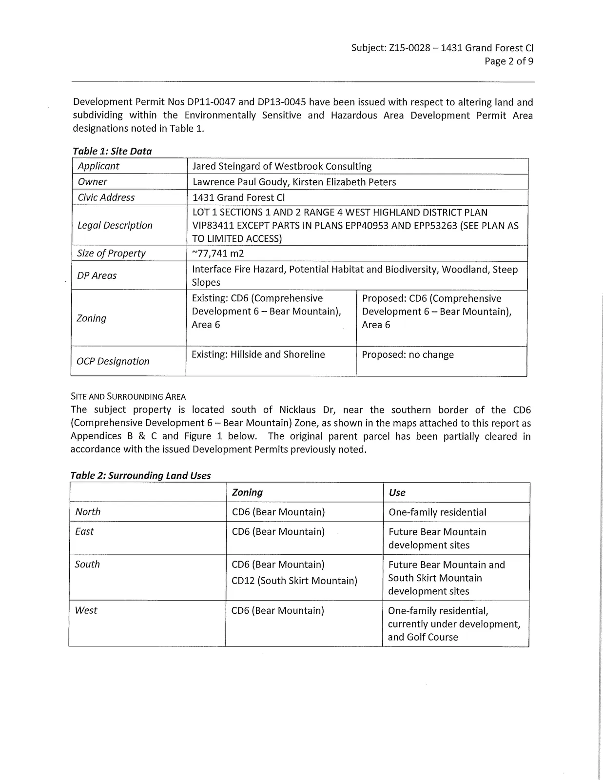
Table 1: Site Data
| Item | Details |
|---|---|
| Applicant | Jared Steingard of Westbrook Consulting |
| Owner | Lawrence Paul Goudy, Kirsten Elizabeth Peters |
| Civic Address | 1431 Grand Forest Cl |
| Legal Description | LOT 1 SECTIONS 1 AND 2 RANGE 4 WEST HIGHLAND DISTRICT PLAN VIP83411 EXCEPT PARTS IN PLANS EPP40953 AND EPP53263 (SEE PLAN AS TO LIMITED ACCESS) |
| Size of Property | —77,741 m2 |
| DP Areas | Interface Fire Hazard, Potential Habitat and Biodiversity, Woodland, Steep Slopes |
| Zoning | Existing: CD6 (Comprehensive Development 6 — Bear Mountain), Area 6 Proposed: CD6 (Comprehensive Development 6— Bear Mountain), Area 6 |
| OCP Designation | Existing: Hillside and Shoreline Proposed: no change |
SITE AND SURROUNDING AREA
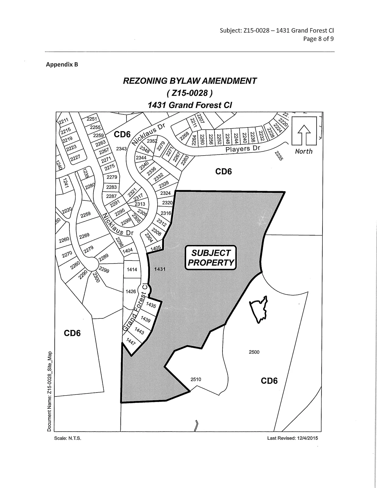
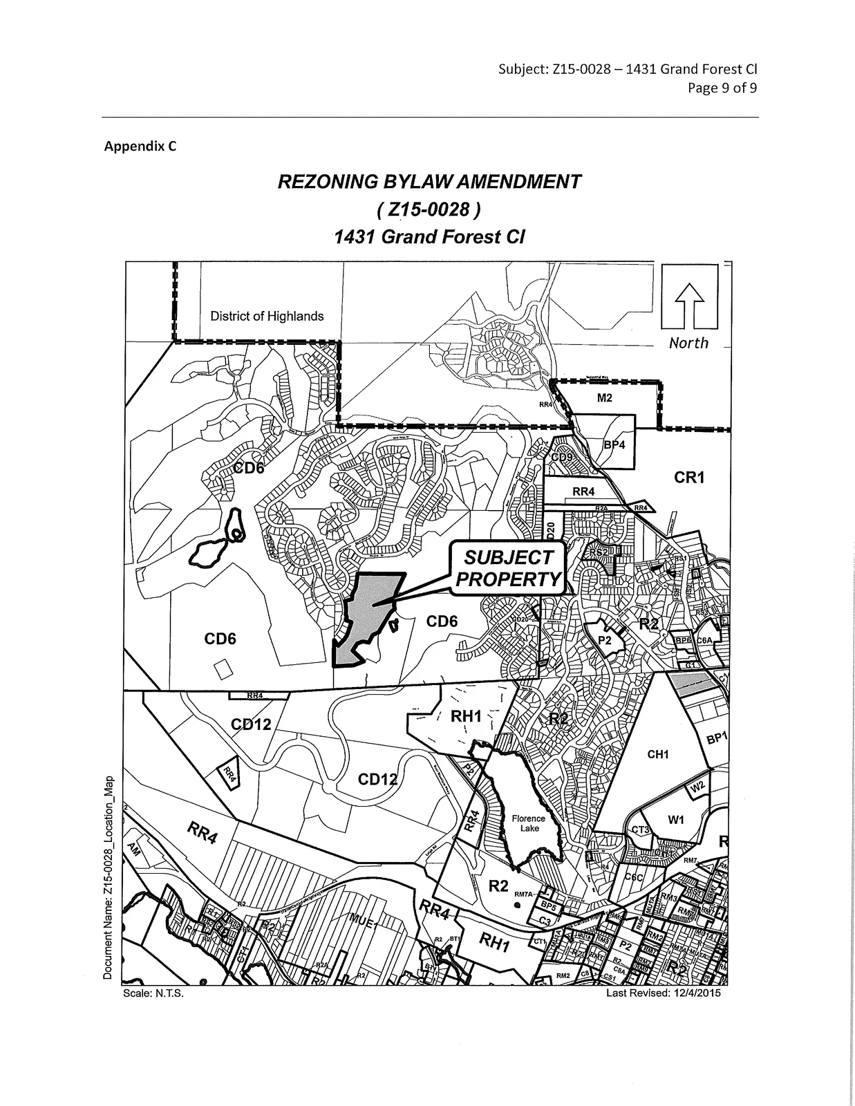
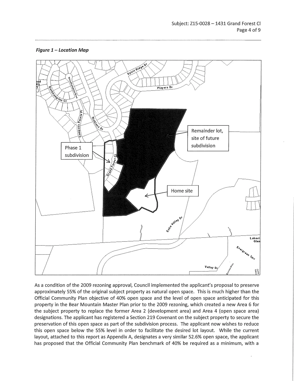
The subject property is located south of Nicklaus Dr, near the southern border of the CD6 (Comprehensive Development 6 — Bear Mountain) Zone, as shown in the maps attached to this report as Appendices B & C and Figure 1 below. The original parent parcel has been partially cleared in accordance with the issued Development Permits previously noted.
Table 2: Surrounding Land Uses
| Direction | Zoning | Use |
|---|---|---|
| North | CD6 (Bear Mountain) | One-family residential |
| East | CD6 (Bear Mountain) | Future Bear Mountain development sites |
| South | CD6 (Bear Mountain), CD12 (South Skirt Mountain) | Future Bear Mountain and South Skirt Mountain development sites |
| West | CD6 (Bear Mountain) | One-family residential, currently under development, and Golf Course |
Figure 1 — Location Map
COUNCIL POLICY
Official Community Plan
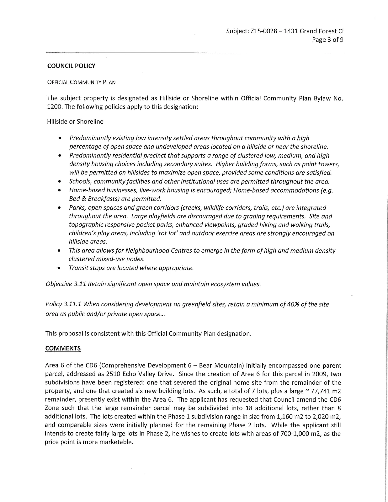
The subject property is designated as Hillside or Shoreline within Official Community Plan Bylaw No. 1200. The following policies apply to this designation:
Hillside or Shoreline
- Predominantly existing low intensity settled areas throughout community with a high percentage of open space and undeveloped areas located on a hillside or near the shoreline.
- Predominantly residential precinct that supports a range of clustered low, medium, and high density housing choices including secondary suites. Higher building forms, such as point towers, will be permitted on hillsides to maximize open space, provided some conditions are satisfied.
- Schools, community facilities and other institutional uses are permitted throughout the area.
- Home-based businesses, live-work housing is encouraged; Home-based accommodations (e.g. Bed & Breakfasts) are permitted.
- Parks, open spaces and green corridors (creeks, wildlife corridors, trails, etc.) are integrated throughout the area. Large playfields are discouraged due to grading requirements. Site and topographic responsive pocket parks, enhanced viewpoints, graded hiking and walking trails, children's play areas, including 'tot lot' and outdoor exercise areas are strongly encouraged on hillside areas.
- This area allows for Neighbourhood Centres to emerge in the form of high and medium density clustered mixed-use nodes.
- Transit stops are located where appropriate.
Objective 3.11 Retain significant open space and maintain ecosystem values.
Policy 3.11.1 When considering development on greenfield sites, retain a minimum of 40% of the site area as public and/or private open space...
This proposal is consistent with this Official Community Plan designation.
COMMENTS
Area 6 of the CD6 (Comprehensive Development 6 — Bear Mountain) initially encompassed one parent parcel, addressed as 2510 Echo Valley Drive. Since the creation of Area 6 for this parcel in 2009, two subdivisions have been registered: one that severed the original home site from the remainder of the property, and one that created six new building lots. As such, a total of 7 lots, plus a large — 77,741 m2 remainder, presently exist within the Area 6. The applicant has requested that Council amend the CD6 Zone such that the large remainder parcel may be subdivided into 18 additional lots, rather than 8 additional lots. The lots created within the Phase 1 subdivision range in size from 1,160 m2 to 2,020 m2, and comparable sizes were initially planned for the remaining Phase 2 lots. While the applicant still intends to create fairly large lots in Phase 2, he wishes to create lots with areas of 700-1,000 m2, as the price point is more marketable.
Figure and site context:
- Phase 1 subdivision
- Remainder lot, site of future subdivision
- Home site
Open Space / Covenant
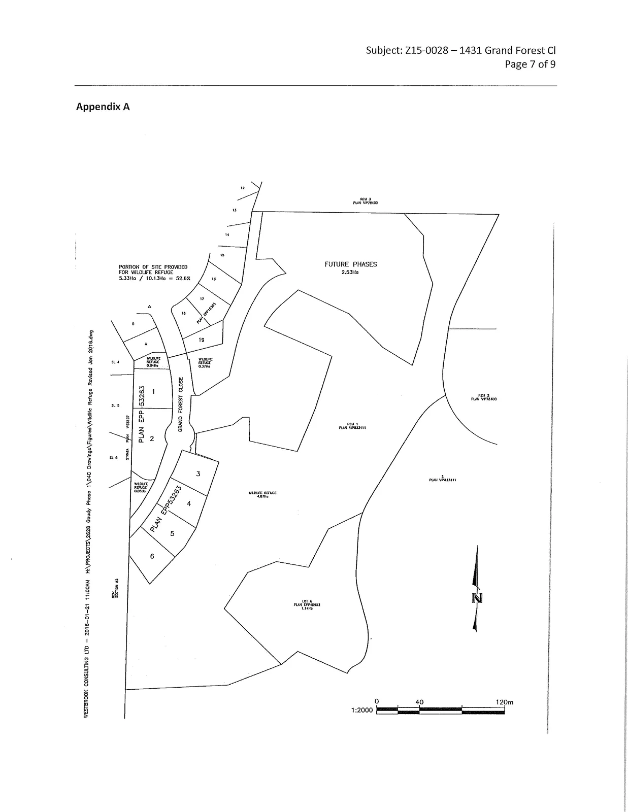
As a condition of the 2009 rezoning approval, Council implemented the applicant's proposal to preserve approximately 55% of the original subject property as natural open space. This is much higher than the Official Community Plan objective of 40% open space and the level of open space anticipated for this property in the Bear Mountain Master Plan prior to the 2009 rezoning, which created a new Area 6 for the subject property to replace the former Area 2 (development area) and Area 4 (open space area) designations. The applicant has registered a Section 219 Covenant on the subject property to secure the preservation of this open space as part of the subdivision process. The applicant now wishes to reduce this open space below the 55% level in order to facilitate the desired lot layout. While the current layout, attached to this report as Appendix A, designates a very similar 52.6% open space, the applicant has proposed that the Official Community Plan benchmark of 40% be required as a minimum, with a greater amount preserved as possible. If Council is supportive of this request, the existing Section 219 Covenant may be modified as part of the Phase 2 subdivision process. Prior to consideration of the amended Covenant, a development permit amendment with supporting report from the project biologist regarding the modified open space will be required.
Servicing, BC Hydro, and Other Requirements
- As part of the Phase 2 subdivision process, the applicant will also be required to update the existing approved stormwater management plan and civil drawings demonstrating the road dedication, frontage improvements and utility extensions that will be required to serve the lots.
- Due to the current BC Hydro capacity issues in North Langford, the applicant will not only have to extend hydro service to the lots, but receive confirmation that they may connect the lots to the system prior to subdivision approval. BC Hydro was sent a referral regarding this application, but no response has been received to date, and no response may be expected at this stage, as subdivision and an application for power from the applicant is what drives BC Hydro's consideration.
- It is also noted that the original application put forward Phase 2 as a strata, and as such maintenance would be a private strata matter. The new intent is to develop Phase 2 as non-strata (fee-simple). If the civil drawings can demonstrate compliance with Bylaw No. 1000 to achieve this, the roads would be dedicated as City right-of-way (as opposed to strata common property) and therefore the maintenance responsibility would fall to the City.
- The project engineer will furthermore be required to provide FUS calculations in accordance with Bylaw No. 1000 as part of the subdivision process. If the available water pressure available is insufficient, the applicant will be required to increase building setbacks or install sprinklers in the homes.
- The subject property is within the Fire Department referral area and may be determined to be outside of the 10 minute response time. Lot and building designs may need to accommodate the extra Building Code requirements related to spatial separations.
FINANCIAL CONTRIBUTIONS
No change to the density permitted in the CD6 (Comprehensive Development 6 — Bear Mountain) zone as a whole is proposed as part of this application; therefore no financial implications for the City are anticipated. Amenity contributions will be provided per wording currently imbedded in the CD6 Zone, and DCCs will be provided as required by Bylaw No. 26.
OPTIONS
Option 1
That the Planning, Zoning and Affordable Housing Committee recommend that Council:
- Direct staff to prepare a bylaw to amend the maximum number of one-family dwelling lots permitted in Area 6 of the CD6 Zone from 15 to 25; and
- Direct staff to amend the Section 219 Covenant such that no less than 40% of the original 2510 Echo Valley Dr subject property is preserved as natural open space as part of the Phase 2 subdivision process, and that the revised boundary of the open space preservation area be designated by a development permit amendment;
OR Option 2
- Reject this application for rezoning.
SIGNATURES / REVIEW
eah Stohrian1i, MCIP, RPP
at
Baldwin, MCIP, RPP
Brent Molnar, AScT
Deputy Director of Planning
Director of Planning
Manager of Land Development
Michelle Mahovlich, P.Eng
Mike Leskiw
Bob Beckett
Director of Engineering
Parks Manager
Fire Chief
Steve Ternent
Treasurer
Jim Bowden
Administrator
:Is
APPENDICES
Appendix A — Site Plan / Portion of Site Provided for Wildlife Refuge
- PORTION OF SITE PROVIDED FOR WILDLIFE REFUGE
5.33110 / 10.12110 = 52.6%
Scale: 1:2000
Appendix B — Rezoning Bylaw Amendment Map (Z15-0028)
SUBJECT PROPERTY
REZONING BYLAW AMENDMENT ( Z15-0028 )
1431 Grand Forest Cl
Scale: N.T.S.
Last Revised: 12/4/2015
Appendix C — Rezoning Bylaw Amendment Location Maps / Details (Z15-0028)
Last Revised: 12/4/2015
Scale: N.T.S.