DocumentsStaff ReportJan 16, 2017Pages 49–54
Staff Report — Application to Rezone 694 Hoylake Avenue (Z16-0015) to RM7A (approx. 10 townhouses)
Planning staff report for rezoning 694 Hoylake Ave from R2 to RM7A to enable ten stratified townhouse units; includes site description, OCP compliance, development permit area considerations, parking and proposed variances.
Key facts
- Applicant: Brant Hoff on behalf of Nicholas Salvador
- Civic address: 694 Hoylake Ave; property size: 1,534.74 m2
- Proposal: 10 townhouse units; parking proposed 2 stalls/unit plus 2 visitor stalls = 22 stalls
- Variances requested: front yard setback range 0–1.5 m (variance), interior side yard 1.5 m (variance), others noted
- DP areas: Riparian Environmental Protection and Flood Plain Hazardous Condition; Riparian assessment submitted
Staff Report to Planning, Zoning and Affordable Housing Committee
Date
October 24, 2016
Department
Planning
Application No.
Z16-0015
Subject
Application to Rezone 694 Hoylake Avenue from R2 (One- and Two-Family Residential) to RM7 (Medium Density Apartment A) to permit the development of approximately 10 Townhouses units
PURPOSE
Brant Hoff has applied on behalf of Nicholas Salvador to rezone 694 Hoylake Ave from R2 (One- and Two-Family Residential) zone to RM7A (Medium Density Apartment A) zone to permit the development of approximately 10 townhouse units.
BACKGROUND
PREVIOUS APPLICATIONS
An application for subdivision was applied for in 2014 (SUB14-0032) to create two lots, each containing one of the existing dwellings currently on the parcel. However, the subdivision application was never pursued by the applicant to completion, so the application expired.
Table 1: Site Data
| Item | Details |
|---|---|
| Applicant | Brant Hoff |
| Owner | Nicholas Salvador |
| Civic Address | 694 Hoylake Ave |
| Legal Description | LOT 4, SECTION 1, RANGE 3 WEST, HIGHLAND DISTRICT, PLAN 38045 |
| Size of Property | 1534.74 m2 or 0.38 acres |
| DP Areas | Riparian Environmental Protection Development Permit Area; Flood Plain Hazardous Condition Development Permit Area |
| Zoning | Existing: R2 Proposed: RM7 |
SITE AND SURROUNDING AREA
The subject parcel shares its property lines with low density residential developments in the form of one family dwellings. The subject site is within close proximity to a variety of commercial services and businesses. Millstream Village with its various retail and service providers is located within walking distance to the subject parcel. Millstream and Lakewood Elementary schools are both close to the parcel as is Lake Ida Anne which has a small walking trail around its perimeter.
Across Hoylake Avenue, to the south of the subject property, the parcel at 691/697 Hoylake Avenue was rezoned in 2015 (Z13-0014) from RH1 (Mobile Home Park) to C6A (Neighbourhood Mixed-Use). This zoning amendment included a modification to the C6A zone to allow for residential dwellings on the main floor as well as a height allowance of 6 storeys. A traffic study was requested by Council as part of the original rezoning which recommended that the developer extend the sidewalk along Millstream Road frontage to Hoylake Avenue, and continue this sidewalk along the Hoylake Avenue Frontage to the site driveway. As well, the study recommended that the signal timing at Millstream Road/Treanor Avenue be updated. This traffic study was approved by the Director of Engineering and is to be implemented at the time of subdivision or building permit. A subsequent Development Variance Permit (DVP15-0013) was approved which varied the building setbacks to side lot lines and allowed portions of the building to project into required setbacks. Also varied was the amount of parking on site, from the required two stalls for units with more than two bedrooms to one stall per unit regardless of the number of bedrooms. The Development Permit that subsequently followed the DVP (DP15-0047) was to allow for two 5 storey apartment buildings with a total of 147 residential units and construction is currently underway.
Other than this development the Hoylake Avenue neighbourhood has not experienced a great deal of redevelopment of its primarily residential parcels.
Table 2: Surrounding Land Uses
| Zoning | Use |
|---|---|
| North (2287 Millstream Road) R2 (One and Two Family Residential) Zone |
One family dwelling |
| East (684 Hoylake Ave) R2 (One and Two Family Residential) Zone |
One family dwelling |
| South (691 Hoylake Ave) C6A (Neighbourhood Mixed Use) Zone |
Apartment style residential buildings (147 units) |
| West (696 & 698 Hoylake Ave) R2 (One and Two Family Residential) Zone |
Two family dwelling |
COUNCIL POLICY
OFFICIAL COMMUNITY PLAN (OCP)
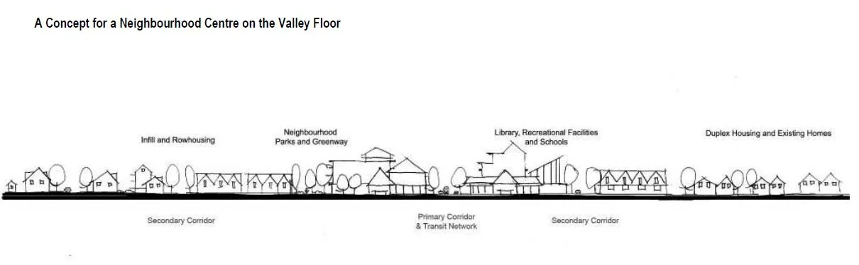
The OCP designates the South portion of this property as Neighbourhood Centre. The Neighbourhood Centre is defined as:
- Predominantly residential precinct that supports a range of medium and high density housing, including affordable and rental housing
- Schools, community facilities, and other institutional uses also define neighbourhood centres when supported by housing and services in close proximity
- A range of parks and open spaces are integrated throughout centres
- Small scale local-serving retail nodes defines the predominant commercial uses
Figure 1: Neighbourhood Centre Concept
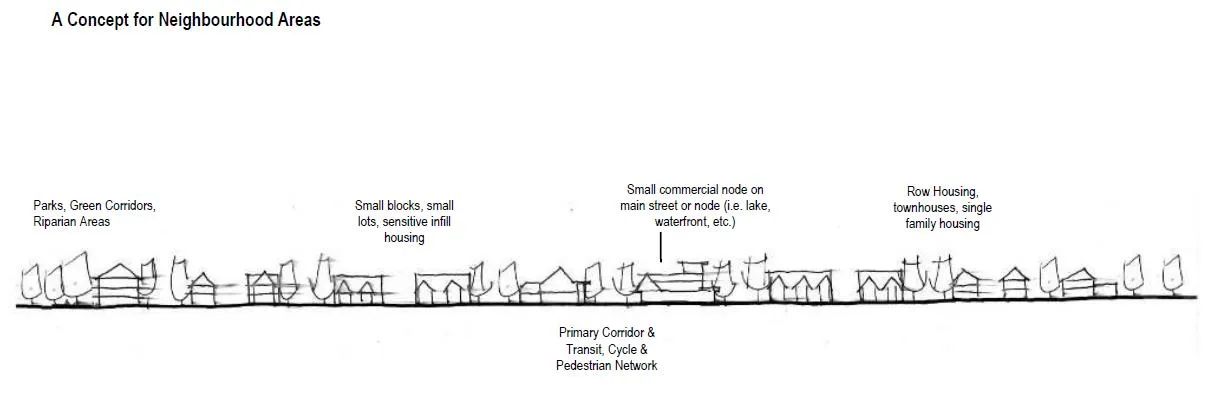
The OCP designates the North portion of this property as Neighbourhood. The Neighbourhood is defined as:
- Predominantly residential precinct that supports a range of low and medium density housing choices including secondary suites
- This area allows for residential and mixed use commercial intensification of streets that connect centres and/or are serviced by transit
- Schools, community facilities, and other institutional uses are permitted throughout the area
- Retail servicing local residents is encouraged along transportation corridors
- Home-based businesses, live work housing is encouraged
- Parks, open spaces and recreational facilities are integrated throughout the area
- This area allows for Neighbourhood Centres to emerge in the form of medium density mixed use nodes at key intersections
- Transit stops are located where appropriate
Figure 2: Neighbourhood Concept
COMPLIANCE WITH THE OFFICIAL COMMUNITY PLAN (OCP)
The Neighbourhood Centre designation contemplates medium to high density development which is close to services, open space, schools and transit opportunities. The proposed development is within close proximity to two elementary schools, several retail and service businesses within Millstream Village, and recreational sites and meets the density objectives in the OCP.
DEVELOPMENT PERMIT AREAS
A large portion of the parcel lies within a Riparian Development Permit Area due to a water course located at the northerly boundary of the parcel. As such, a Development Permit will be required prior to any alteration of land. A draft Riparian Areas Regulation Assessment Report has been submitted with this rezoning application, as establishment of the minimum Streamside Protection and Enhancement Area (SPEA) is critical in determining the feasibility of developing this property.
Figure 3: Flagged SPEA Area
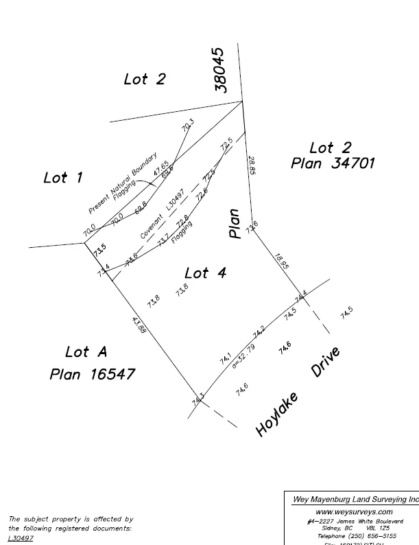
The subject property also falls within the Hazardous conditions Development Permit area as the property falls within the 200 year flood plain created by a water course. However, as the flood plain is within the Riparian Area (and SPEA) this area will not be altered and will remain as a non-disturbance area.
COMMENTS
DEVELOPMENT PROPOSAL
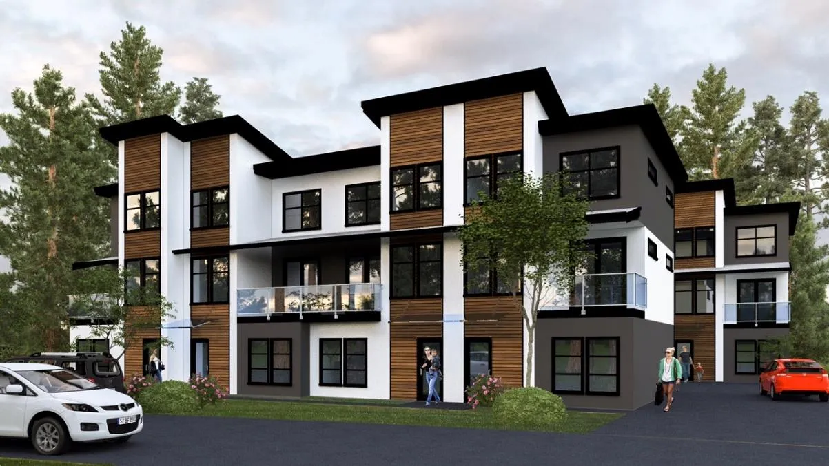
The applicant intends to build ten stratified townhouse units with four units directly fronting Hoylake Avenue and the remaining six units located along the rear of the property on the edge of the designated SPEA. The units will be accessed via a main driveway off of Hoylake Avenue on the east portion of the parcel and adjacent to an existing easement on the neighbouring parcel. Visitor parking is proposed to be located along the west side of the property, with one stall being accessed directly off of Hoylake Ave and the other accessed via the driveway into the strata property.
As the rezoning application primarily addresses land use and density, the design of the site, including the form and character, will be addressed through the Development Permit process after the rezoning process is complete. Council should note that as the site plan parameters haven’t been proven out by a BC Land Surveyor the proposed site layout (shown in Figure 4) may be subject to some modifications.
Figure 4: Proposed Site Plan
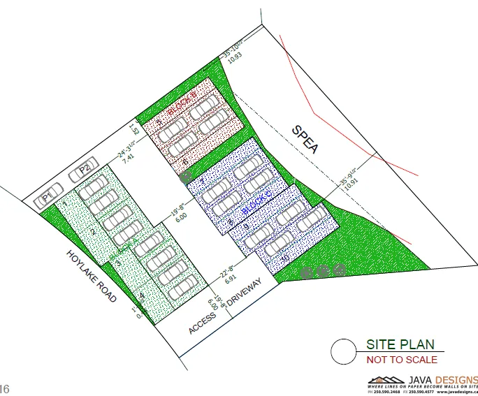
PARKING
The applicant is proposing parking which complies with the regulations of Section 4.01.01 in the Zoning Bylaw at 2 parking spaces per dwelling unit and 2 additional onsite spaces for visitors. Access to the site must conform to Building Code regulations, and a turning template to prove units are accessible by emergency vehicles must be submitted at time of development permit.
Table 3: Proposal Data
| Permitted by R2 (Current Zoning) | Permitted by RM7A (Proposed Zoning) | Proposed by Rezoning Application |
|---|---|---|
| Height | 9 m 3 stories |
3 stories |
| Site Coverage/ FAR | 35% | 1.25 |
| Front Yard Setback | 6 m | 7.5 m |
| Interior Side Yard Setback | 1.5 m | 3 m |
| Rear Yard Setback | 6 m | 7.5 m |
| Parking Requirement | 2 parking stalls per unit | 2 spaces per dwelling, and an additional 2 stalls for visitor parking (22 stalls) |
*Variance Required
VARIANCES
As shown in Table 3, the applicant is proposing a range of 0 - 1.5 m for the front yard setback which will result in minimal landscaping. As the boulevard frontage along the property is 6.30 m wide at narrowest point, the perceived setback should be negligible. Council may wish to request the applicant provide landscaping within the boulevard in lieu of providing it in the setback. This will ensure that the landscape objectives of the Design Guidelines are achieved. Furthermore, Council may wish to request that the applicant provide irrigation to the landscaping from the subject strata property and have the landscaping be irrigated in perpetuity by the strata.
Figure 5: Proposed Front Elevation, facing Hoylake Avenue