DocumentsStaff ReportOct 16, 2017Pages 17–28
Staff Report: Z17-0034 - Application to Rezone 2955 Irwin Road (Keycorp / Margaret Jones)
Planning staff report recommending First Reading to rezone 2955 Irwin Road to permit an 18 small-lot subdivision, with recommended conditions and financial/servicing requirements.
Key facts
- Applicant: Duncan Magee (Keycorp Developments) on behalf of Margaret May Jones
- Civic Address: 2955 Irwin Road; Property size: 8,459 m2 (2.3 acres)
- Proposal: 18 lots, proposed minimum lot size 250 m2; shared driveways and landscaping
- Amenity contributions: $6,000 per standard lot / $3,960 per small lot (General Amenity), $1,000 / $660 (Affordable Housing)
- Estimated DCCs & fees total approx. $230,127.12 (table shows subtotal and CRD/School amounts)
Staff Report to Planning, Zoning and Affordable Housing Committee
Date: September 11, 2017
Department: Planning
Application No.: Z17-0034
Subject: Application to Rezone 2955 Irwin Road from RR4 (Rural Residential 4) zone to RS3 (Residential Small Lot 4) zone to allow for the development of an 18 small lot subdivision.
PURPOSE
Duncan Magee with Keycorp Developments has applied on behalf of Margaret Jones to rezone 2955 Irwin Road from RR4 (Rural Residential 4) zone to RS4 (Residential Small Lot) zone to allow an 18 small lot subdivision of single family dwellings.
BACKGROUND
PREVIOUS APPLICATIONS
There are no development permit applications for the subject parcel in recent recorded history.
Table 1: Site Data
| Item | Details |
|---|---|
| Applicant | Duncan Magee |
| Owner | Margaret May Jones |
| Civic Address | 2955 Irwin Road |
| Legal Description | Lot 1, Section 26, Goldstream District, Plan 24172 |
| PID | |
| Size of Property | 8459 m2 (2.3 acres) |
| DP Areas | High Fire Hazard Area, Sensitive Habitat and Biodiversity Area, Riparian Area |
| Zoning - Existing | RR4 (Rural Residential Zone 4) |
| Zoning - Proposed | RS4 (Residential Small Lot 4) |
| OCP Designation - Existing | Hillside/Shoreline |
| OCP Designation - Proposed | No Changes |
SITE AND SURROUNDING AREA
The subject property is located in west Langford and is south of Langford Lake, between the community of Westhills and the Juan de Fuca regional boundary. Rural, forested properties are typical along Irwin Road which was recently connected to the West Shore Parkway to facilitate the ongoing development and access for the community of Westhills and surrounding areas.
The single family home that sits on the 8459 m2 (2.3 acre) property is contained on the flat portion of the parcel that has a slight but steady incline from Irwin Road. Access from Irwin Road is not currently available directly to the parcel, as it separated from Irwin Road by a linear strip of land owned by the Capital Regional District. A process is in place that will see this piece of land dedicated as City road.
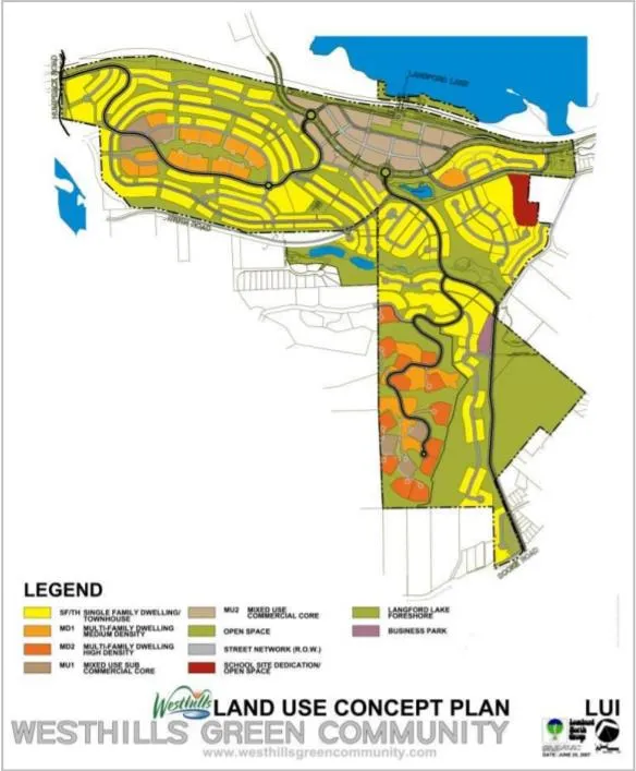
The proposal will be developed adjacent to a block of townhouses and open space amenity land, which will be a part of a new Westhills subdivision, however, this property is not tied to the development and is not included within Westhill’s Neighbourhood Area Plan, nor to the Westhills Comprehensive Development zone within the Zoning Bylaw No. 300.
Table 2: Surrounding Land Uses
| Location | Zoning | Use |
|---|---|---|
| North | CD3 (Comprehensive District 3 – Westhills) | Townhomes (in progress) |
| East | CD3 (Comprehensive District 3 – Westhills) | Future Single Family or Townhomes |
| South | CD3 (Comprehensive District 3 – Westhills) | Future Park |
| West | P1A (Neighbourhood Institutional) | Agricultural Use |
Figure 1: Westhills Community Land Use Concept Plan and 2955 Irwin Road (at arrow)
COUNCIL POLICY
OFFICIAL COMMUNITY PLAN
The subject property is designated as Hillside/Shoreline within Langford’s Official Community Plan. This policy area does not contain density modifiers and supports low density areas as well as open space around hills and lake shores.
Hillside or Shoreline Predominantly existing low intensity settled areas throughout community with a high percentage of open space and undeveloped areas located on a hillside or near the shoreline.
- Predominantly residential precinct that supports a range of clustered (See Glossary & next page) low, medium and high density housing choices including secondary suites. Higher building forms, such as point towers, will be permitted on hillsides to maximize open space provided some conditions are satisfied (see policies for this area)
- Schools, community facilities and other institutional uses are permitted throughout the area
- Home-based businesses, live-work housing is encouraged; Home-based accommodations (e.g. Bed & Breakfasts) are permitted.
- Parks, open space and green corridors (creeks, wildlife corridors, trails, etc.) are integrated throughout the area. Large playfields are discouraged due to grading requirements. Site and topographic responsive pocket parks, enhanced viewpoints, graded hiking and walking trails, children’s play areas, including ‘tot lots’ and outdoor exercise areas are strongly encouraged on hillside areas.
- This area allows for Neighbourhood Centres to emerge in the form of high and medium density clustered mixed-use nodes
- Transit stops are located where appropriate
DEVELOPMENT PERMIT AREAS
As a creek lies to the south of the subject property, and as the south western portion is within an area designated as Riparian Area development, within this area will be subject to the recommendations submitted within a Riparian Area Report, prepared by a Registered Professional Biologist. The entirety of the parcel is also within an area that has been flagged as an area of potential biodiversity and ecological significance. An Environmental Impact Assessment report will be required in order to identify the retention of natural areas. Council should note that the outcome of both these reports may result in a significant change to the subdivision plan as proposed, however the applicant has not submitted these documents with their application to rezone.
Due to the location of the subject parcel, surrounded by forest and thick vegetation and within the High Risk Fire Hazard Development Permit Area, a report prepared by a Professional Registered Forester is required to assess how building materials and spatial distance can mitigate the fire risks.
COMMENTS
DEVELOPMENT PROPOSAL
As previously mentioned, the parcels along Irwin Road are large, rural properties that have not yet experienced redevelopment due to zoning and policy restrictions as well as the lack of services available to them. Under their current zone, RR4 or Rural Residential 4 no lots less than 40 ha or 100 acres are able to be created through subdivision of a parcel, therefore a rezoning application is required in order to subdivide this 2.3 acre parcel into smaller lots.
The RS4, Residential Small Lot 4 zone, permits the creation of 400 m2 lots when the applicant contributes the General and Affordable Housing amenity funds, and is listed within Table AD of the Zoning Bylaw. The applicant has requested lot sizes smaller than what is permitted in the zone, with a contribution to the aforementioned amenity funds. A text amendment to the zone will be required in order to permit the smaller lot sizes, on the condition that no more than 18 parcels will be created from the subject property.
The applicant wishes to develop the 18 lot subdivision of single family dwellings, which will have the potential to include secondary suites on lots that are larger than 400 m2 in accordance with the RS4, Residential Small Lot 4, Zone.
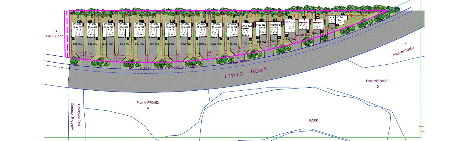
In effort to preserve the existing landscape, the applicant is proposing a layout that would be more culturally sensitive to the rural context of the area. The applicant is proposing that parcels will share driveways, to minimize number of driveway access points along Irwin Road and heavily landscape the parcel frontages. This will create the semblance of greenspace along the frontage that will also consist of a swales that together will mitigate the perceived views of the proposed development along Irwin Road. Council may wish to secure this driveway design and landscaping in the form of a section 219 covenant, registered on the subject parcel.
Figure 2: Preliminary design, showing landscaping and shared driveway, also included as Appendix “A”
PARKING
In accordance with the Zoning Bylaw, two parking spots are required for a single family dwelling as well as an additional spot for any secondary suites that are proposed.
The plan to share driveways will provide more than the minimum required off street parking spaces, and on some parcels up to triple the required amount is being provided. Due to this, the applicant intends to request a variance to the required on street parking requirement in accordance with Bylaw No. 1000. If Council feels that the proposed amount of off street parking is sufficient for both residents and visitors to the properties, they may wish to direct the applicant to apply for a development variance permit and direct staff to proceed with the variance request.
DESIGN
No building design drawings have been submitted with this application. A form and character development permit will be required for homes on lots less than 550 m2 and for any proposed townhouses.
The applicant has submitted a subdivision layout that Council may wish to secure through within a section 219 covenant registered on the title associated with the parcel.
PARKS
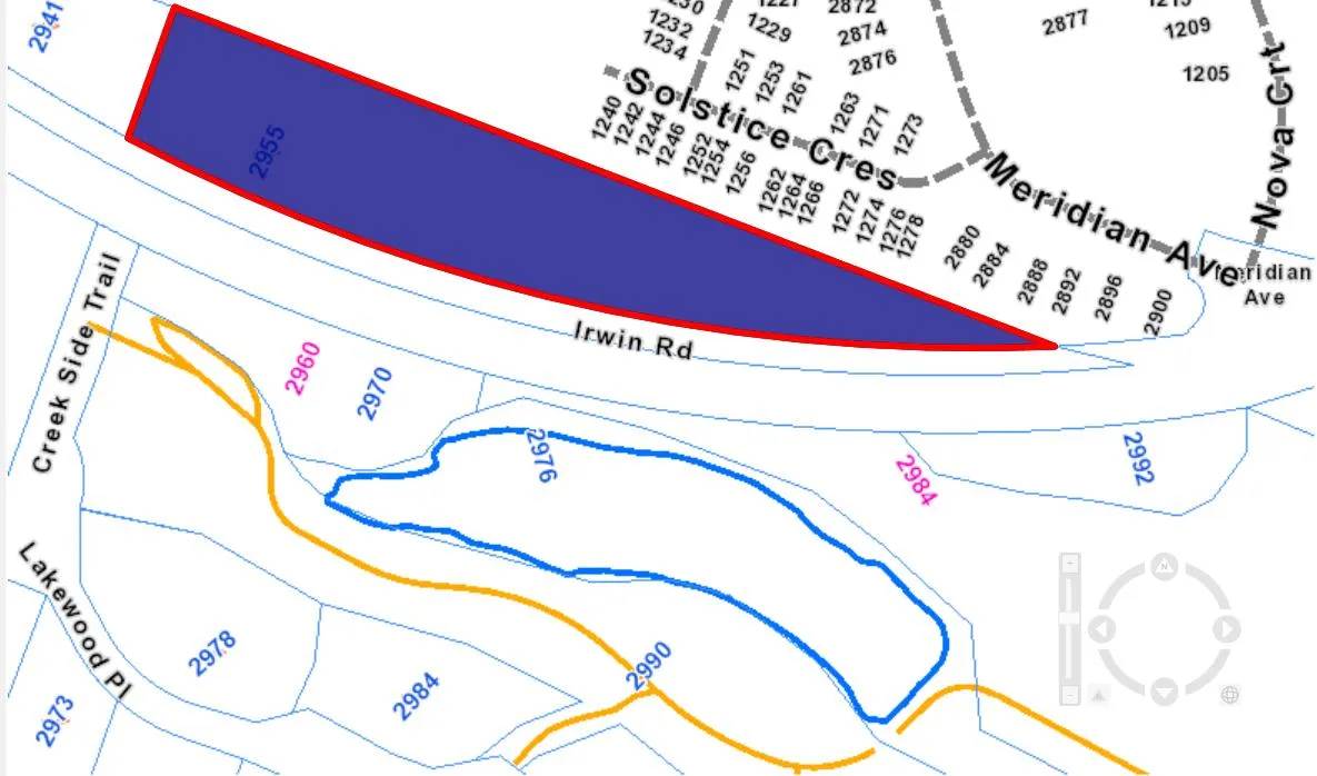
Trail infrastructure along Irwin Road will be add to the TransCanada Trail cyclist corridor as well as function as a trail gateway to the Humpback Reservoir. Trail enhancements may include a multi-use trial on the north side of the existing road surface.
Figure 1: subject parcel highlighted, trail system in yellow surrounding Paradise Ponds Park
Council may wish to secure these improvements within as section 219 covenant as well as requesting that a statutory right of way be registered on the subject property in accordance with the requirements set forth by the Manager of Parks and the Director of Engineering and Bylaw No.1000 Trail Standards.
Table 3: Proposal Data
| Item | Permitted by RR4 (Current Zoning) | Permitted by RS4 (Proposed Zoning) | Proposed by this rezoning application: |
|---|---|---|---|
| Permitted Use | -One or Two Family Dwellings -Secondary Suites within one family dwelling | -One Family Dwellings -Secondary suites on parcels greater than 400 m2 | As per zone |
| Minimum Lot Size | 100 acres | 400 m2 | 250 m2, a limit of 18 parcels will be permitted |
| Height | 10.5 m | - 8.5 m for parcels less than 550m2 - 9 m for parcels greater or equal to 550m2 | As per zone |
| Site Coverage | 30% or 1000 m2 | 50% | As per zone |
| Front Yard Setback | 7.5 m, although no garage or carport may be located within 5.5 m of any front or exterior line | 3.0 m, although no garage or carport may be located within 5.5 m of the front lot line | As per zone |
| Interior Side Yard Setback | 3 m | 1.2 m | As per zone |
| Exterior Side Yard Setback | 3 m | 3.5 m, although no garage or carport may be located within 5.5 m of the front lot line | As per zone |
| Rear Yard Setback | 10 m | 5.5 m | As per zone |
| Parking Requirement | 2 spaces | 2 spaces | As per regulations |
MOTORIST NETWORK
The connection to Irwin Road from West Shore Parkway was recently completed which opened up access to western Langford for these rural communities. As mentioned the linear parcel that separates Irwin Road and the subject property is in the process of being obtained by the City.
Given the rural context of the subject property, there is very little in the way of infrastructure to support additional modes of transportation. The proposed rezoning will include frontage improvements with bike lanes, sidewalks and light standards that will encourage pedestrian and bicycle powered transportation along the corridor.
The closest transit stops, providing services to the Western Communities and downtown Victoria, are about a 15 minute walk to the Langford Parkway at Langford Lake Road. From there a rider would be required to connect at one of bus exchanges, either Langford Station on Station Avenue in Langford or the Colwood bus exchange on Old Island Highway in Colwood to reach their final destination.
INFRASTRUCTURE
The property is not currently connected to sewer. Sewer with other municipal and regional services must be available at the property prior to subdivision approval. Access to water, and the provision of adequate water pressure to comply with current Fire Underwriter Survey (FUS) calculations shall be secured through a Section 219 covenant, registered on the subject property.
A stormwater management plan must be provided in accordance with the standards of Bylaw No.1000 and to the satisfaction of the Director Engineering. Council may wish to secure the provision and implementation of this plan within a section 219 covenant, registered on the subject property.
Full frontage improvements, to the standards of Bylaw No.1000 and to the approval of the Director of Engineering will be required prior to subdivision approval or building permit issuance, whichever is first. Frontage improvements may include, but are not limited to, bike lanes, sidewalks, on street parking (unless an application to vary this requirement is supported by Council), and light standards.
A road dedication may be required in order to facilitate the necessary frontage improvements, as such the applicant will be required to provide frontage drawings, prior to Public Hearing, in order to determine if road dedication is required. If road dedication is required, Council may wish to obtain this prior Bylaw Adoption.
NEIGHBOURHOOD CONSULTATION
The applicant has been asked to provide confirmation that public engagement has occurred with regards to rezoning the property before Public Hearing.
FINANCIAL CONTRIBUTIONS
Rezoning the subject property to permit higher densities of development may increase the assessed value of the property, and this may increase municipal revenue. As the applicant will connect the development to municipal sewers, and as the applicant will complete frontage improvements, the direct capital costs to the municipality associated with this development will be negligible. A summary of the amenity contributions required pursuant to Council’s Amenity Contribution Policy and Development Cost Changes required pursuant to DCC Bylaw No. 26 are listed in Tables 4 and 5 below.
Table 4 – Amenity Contributions per Council Policy
| Amenity Item | Per Single Detached Home | Per Small Lot Detached Home (Equivalent = 0.66) |
|---|---|---|
| General Amenity Reserve Fund | $6,000 | $3,960 |
| Affordable Housing Reserve Fund | $1,000 | $660 |
Table 5 – Development Cost Charges (approximate calculations)
| Development Cost Charge | Per lot contribution | Total |
|---|---|---|
| Roads | $3,985 (@ 1 lot <300m2) $6,056 (@ 17 lots >300 m2 ) | $106,937 |
| Park Improvement | $1,890 (@18 lots) | $34,020 |
| Park Acquisition | $1,100 (@18 lots) | $19,800 |
| Incremental Storage Improvement Fees | $371.25 (@ 4 lots <550 m2 no suite) $495 (@14 lots < or > 550 m2 with suites) | $8,415 |
| Integrated Survey Area | $35 (@ 17 parcels created) | $595 |
| Subtotal (DCCs paid to City of Langford) | $9,431.50 | $169,767 |
| CRD Water | $2,655.34 (@18 lots) | $47,796.12 |
| School Site Acquisition | $698 (@18 lots) | $12,564 |
| TOTAL (estimate) DCCs | $12,784.84 | $230,127.12 |
OPTIONS
Option 1
That the Planning, Zoning and Affordable Housing Committee recommend that Council:
- Give First Reading to Bylaw 1731 in order to amend the text within the RS4 Zone of Zoning Bylaw No.300 to permit lot sizes of 260 m2 , on the subject property, and limit the number of parcels that can be developed on the subject property to 18 parcels. As well as amend the zoning designation of the property located at 2955 Irwin Road from RR4 (Rural Residential 4) zone to RS3 (Residential Small Lot 3 zone) subject to the following terms and conditions:
a) That the owner agrees to provide, as a bonus for increased density, the following contributions per new lot created, prior to subdivision approval:
i. $6,000 towards the General Amenity Reserve Fund per single family lot; and
ii. $3,960 towards the General Amenity Reserve Fund per single family small lot;
iii. $1,000 towards the Affordable Housing Reserve Fund per single family lot; and
iv. $660 towards the Affordable Housing Reserve Fund per single family small lot;
b) That the applicant provides, prior to Public Hearing, the following:
i. Confirmation that some sort of public engagement has occurred in regards to the subject application to rezone 2955 Irwin Road;
ii. A frontage improvement plan to the satisfaction of the Director of Engineering and Bylaw No.1000.
c) That the applicant provides, prior to Bylaw Adoption, a section 219 covenant, registered in priority of all other charges on title, that agrees to the following:
i. That, prior to subdivision approval or building permit issuance, whichever is first, the applicant provide a Construction Parking Management Plan, to the standards of the Subdivision and Servicing Bylaw, No.1000 and to the satisfaction of the Director of Engineering;
ii. That the applicant agrees to develop the parcels in substantial compliance to the plans attached as Appendix A in regards to landscaping and driveway design, to the satisfaction of the Director of Planning;
iii. That, prior to subdivision approval or building permit issuance, whichever is first, the applicant provide a Stormwater Management Plan, to the standards of the Subdivision and Servicing Bylaw, No.1000 and to the satisfaction of the Director of Engineering;
iv. That the applicant acknowledge and agree that no recreational vehicles or commercial vehicles will be allowed to be stored or parked on a driveway for more than 48 hours on driveways.
v. That, prior to building permit issuance, the applicant register an access agreement for the shared driveways between single family dwellings, to the satisfaction of the Approving Officer.
vi. That, prior to subdivision approval or building permit issuance, whichever is first, the applicant will implement the recommendations within the stormwater management plan as well as assumes responsibility for all costs, on site and off site, required to manage the subject property’s drainage concerns;
vii. That, prior to subdivision approval or building permit issuance, whichever is first, the applicant provides full frontage improvements and road dedication, if required, to the standards of the Subdivision and Development Servicing Bylaw No. 1000, and to the satisfaction of the Director of Engineering;
viii. That, prior to subdivision approval or building permit issuance, whichever is first, the applicant will register a Statutory Right of Way Plan along the western portion of the property for trail and park improvements;
ix. That, prior to subdivision approval or building permit issuance, whichever is first, the applicant constructs park improvements and trail infrastructure to the standards of Bylaw No.1000 and the Manager of Parks;
x. That, prior to subdivision approval or building permit issuance, whichever is first, the applicant will be required to connect to municipal sanitary sewer
infrastructure which may necessitate the requirement for service upgrades and extensions, all to the standards of the Subdivision and Servicing Bylaw No.1000 and the Director of Engineering; and
xi. That any necessary above or underground infrastructure or servicing upgrades, extensions or other required servicing requirements are to be fulfilled to the standards of Bylaw No. 1000 and the Director of Engineering, and that costs incurred will be the responsibility of the applicant.
d) That, prior to Bylaw Adoption, the applicant submits and registers a road dedication plan, if required, to the satisfaction of the Director of Engineering and to the standards of the Subdivision and Servicing Bylaw No.1000.
e) Direct staff to proceed with the following variance for 2955 Irwin Road, subject to the applicant applying for the necessary DVP:
i. That section 4.11.4 of Bylaw No.1000 be varied from one on street parking space per 2 lots to 0.
OR Option 2
- Reject this application to amend the zoning for 2955 Irwin Road
Submitted by:
Lauren Morhart, MICP, RPP Planner 2
Concurrence:
Matthew Baldwin, MCIP, RPP Director of Planning
Cory Manton, Parks and Recreation Manager
Michelle Mahovlich, P.Eng, P.Geo, Director of Engineering
Leah Stohmann, MCIP, RPP, Deputy Director of Planning
Michael Dillabaugh, CPA, CA, Director of Finance
Braden Hutchins, Director of Corporate Services
Darren Kiedyk, Chief Administrative Officer
: lhm