DocumentsStaff ReportMay 7, 2018Pages 39–55
Staff Report — Z16-0026 (Bylaw No.1757) — 3427 Happy Valley Road
Planning staff report recommending rezoning of 3427 Happy Valley Road from RR2 to RM2A to allow approximately 26 townhouse units, proposed amendments to RM2A text (FAR, setbacks, density bonuses) and identifying required conditions (road dedication, stormwater, TIA, covenants).
Key facts
- Applicant: Gary Brown / Paradise Homes Ltd.
- Civic Address: 3427 Happy Valley Road; Legal: Lot 3, Section 85, Metchosin District, Plan 6533, PID 005-857-643
- Site size: 4,305 m2 (1.1 ac); Proposed: approx. 26 townhouse units (~64 units/ha for the site)
- Amenity contributions (Table 5): $6,000 per SFE to General Amenity Reserve; $1,000 per SFE to Affordable Housing Reserve; total estimated $111,020 (for 15.86 SFE listed)
- Estimated DCCs (Table 6): Subtotal to City $221,318.50; total estimated DCCs $296,235.68
Staff Report — Z16-0026 (Bylaw No. 1757) — 3427 Happy Valley Road
Date: January 15, 2018
Department: Planning
Application No.: Z16-0026
Subject
Bylaw No. 1757 - Application to rezone the property at 3427 Happy Valley Road from RR2 (Rural Residential Zone) to Attached Housing (RM2A) and Amend the Text of the RM2A Zone to allow for townhouse developments with reduced setbacks and higher densities
Purpose
Gary Brown of Paradise Homes has applied to rezone the property at 3427 Happy Valley Road from RR2 (Rural Residential 2) to RM2A (Attached Housing) and amend the text of the RM2A Zone to allow for townhouse developments with reduced setbacks and higher densities.
Background
Previous Applications
There are no previous development applications for the subject site.
Table 1: Site Data
| Item | Details |
|---|---|
| Applicant | Gary Brown |
| Owner | Paradise Homes Ltd. |
| Civic Address | 3427 Happy Valley Road |
| Legal Description | Lot 3, Section 85, Metchosin District, Plan 6533, PID 005-857-643 |
| Size of Property | 4,305 m2 (1.1 ac) |
| DP Areas | Habitat & Biodiversity Development Permit Area |
| OCP Designation | Neighbourhood |
| Zoning | Existing: Rural Residential 2 (RR2) — Proposed: Attached Housing (RM2A) |
Site and Surrounding Area
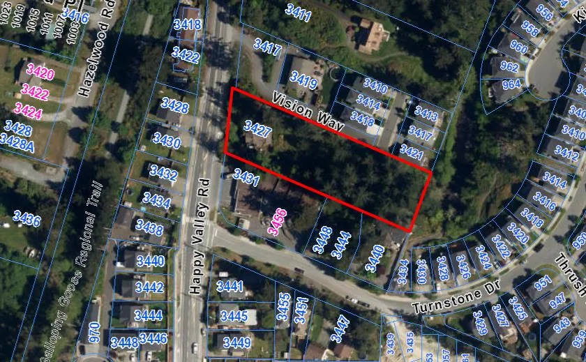
The subject site is located in South Langford, east of Happy Valley Road, north of Turnstone Drive and directly south of Vision Way. The site currently contains a one-family dwelling located on the front portion of the site near Happy Valley Road, and the remainder of the site is heavily treed. The surrounding area contains a variety of residential uses and a neighbourhood convenience and grocery store at the corner of Happy Valley Road and Turnstone Drive.
Table 2: Surrounding Land Uses
| Direction | Zoning | Official Community Plan | Use |
|---|---|---|---|
| North | Residential Small Lot 2 (RS2) | Neighbourhood | One-family dwellings |
| East | Residential Small Lot 2 (RS2) | Neighbourhood | Park and one-family dwellings |
| South | One and Two-Family Residential (R2), and Neighbourhood Commercial (C1) | Neighbourhood | One-family dwellings, neighbourhood grocery store and multi-family residential building |
| West | One and Two-Family Residential A (R2A) | Neighbourhood | One-family dwellings |
Figure 1: Orthophoto of Subject Site
Council Policy
Official Community Plan Designation (OCP)
The subject property is designated as Neighbourhood within the Official Community Plan Bylaw No. 1200. This designation is applied to existing settled areas throughout the community, predominantly those located on the valley floor, and is intended to:
- Be a predominantly residential precinct that supports a range of low and medium density housing choices including secondary suites;
- Allow for residential and mixed use commercial intensification of streets that connect centres and/or are serviced by transit;
- Permit schools, community facilities and other institutional uses throughout the area;
- Encourage retail uses serving local residents along transportation corridors;
- Encourage home-based businesses and live-work housing;
- Integrate parks, open spaces and recreational facilities throughout the area;
- Allow for Neighbourhood Centres to emerge in the form of medium density mixed-use nodes at key intersections; and
- Locate transit stops where appropriate.
The Neighbourhood designation also provides a number of objectives and policies for development, including:
- Objective 3.8: Redevelop and intensify corridors connecting centres.
- Policy 3.8.1: Encourage intensification of transportation corridors in and out of centres as a means to further increase the viability of transit services.
- Policy 3.8.2: Ensure redevelopment along corridors is pedestrian-oriented and consistent with liveable street strategies.
- Objective 3.9: Permit sensitive infill development.
- Policy 3.9.1: Encourage alternative housing types such as coach housing, row housing, live/work units and townhouses that diversify the housing stock.
- Policy 3.9.2: Permit small lot subdivision and clustered densification in established areas.
- Policy 3.9.3: An overall density objective of 40 units per hectare (16 units per acre) for infill development in Neighbourhood designated areas will guide choices about density. Ensure buildings are sited to complement the type, use and character of adjacent buildings and ensure private outdoor spaces for adjacent properties are respected.
Compliance with the OCP
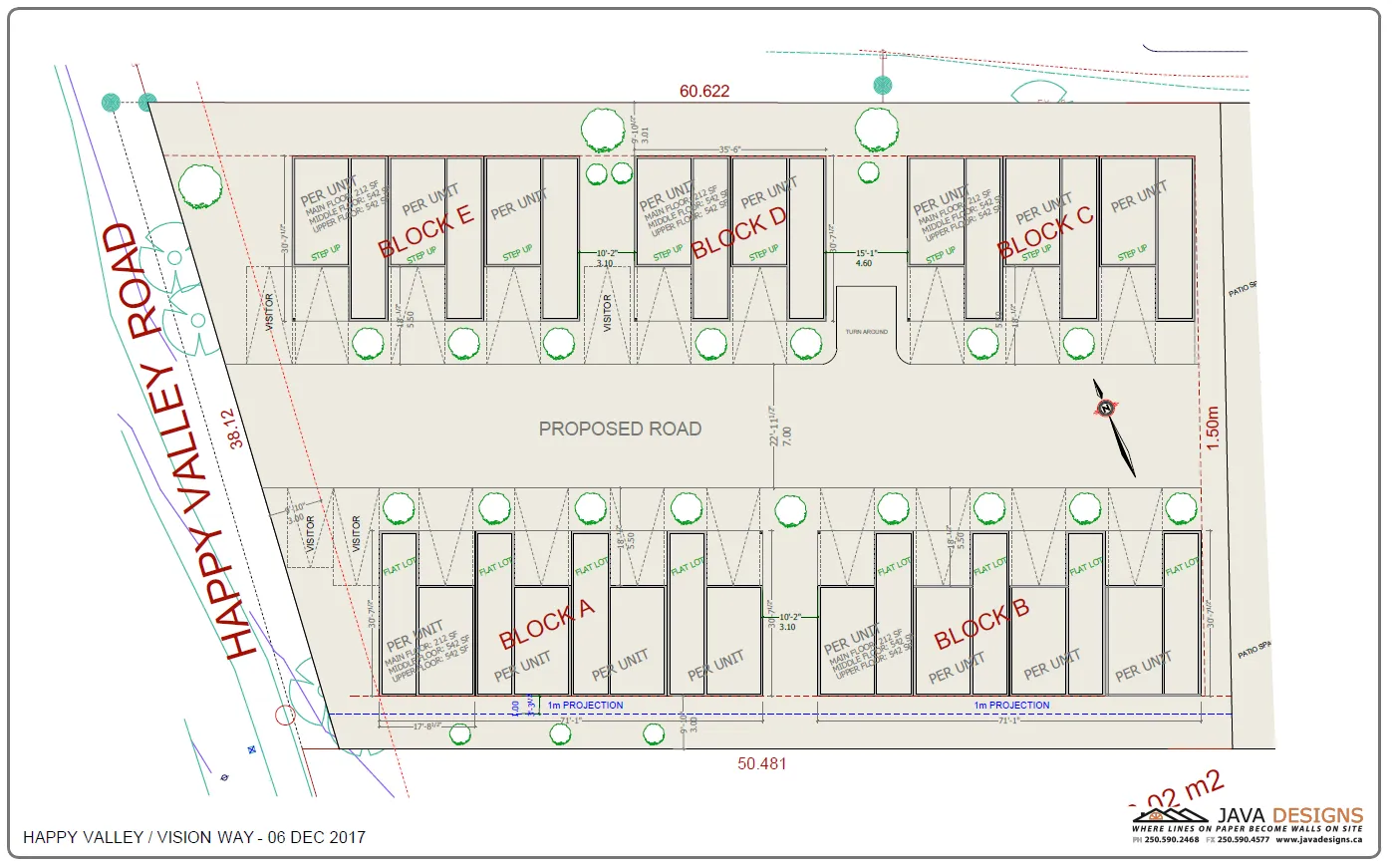
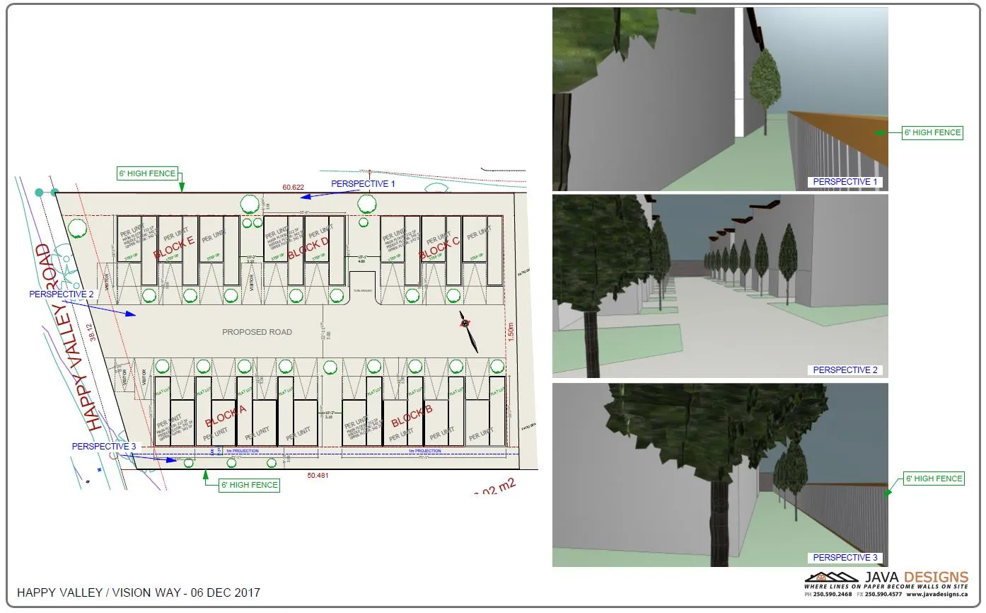
As shown on the attached site plan, the proposed development at 3427 Happy Valley Road will represent an intensification of density along a transportation corridor, as well as a diversification of housing choice in this primarily one-family residential area. The proposed development of approximately 26 townhouse units on the 4,305 m2 (1.1 acre) site represents a density of 64 dwelling units per hectare (24 units per acre). Although this density, calculated for the individual site alone rather than the overall area, is slightly higher than what is called for the in the OCP, it is balanced by the lower density existing in the surrounding neighbourhood.
Development Permit Areas
The subject site is located entirely within the Habitat and Biodiversity Development Permit Area. Should this application for rezoning be approved, a Development Permit informed by a report from a qualified professional will be required prior to development. A Form and Character Development Permit will also be required for the proposed multi-family residential development if this rezoning application is approved.
Comments
Proposed Amendments to RM2A (Attached Housing) Zone
Staff are proposing amendments to the RM2A Zone to increase the maximum density and decrease the minimum setbacks. These amendments are intended to update the RM2A Zone and allow for slightly more compact townhouse developments which still provide usable open space and appropriate on-site parking for residents.
- Current RM2A Zone allows for a maximum floor area ratio (FAR) of 0.5, but can be increased to 0.6 with amenity contributions and to 0.75 with amenity contributions and at least 50% of required parking provided underground. Proposed amendments would increase the maximum FAR to 1.0, with amenity contributions, and would not include an additional increase for underground parking.
- Maximum lot coverage of 40% and maximum height of three storeys would remain the same.
- Proposed reduced setbacks: 5.5 m (18 ft) from any front or exterior side lot line; 7.5 m (25 ft) from at least one interior side or rear lot line and 3.0 m (10 ft) from the other interior side or rear lot lines.
Development Proposal
The applicant has requested that the property at 3427 Happy Valley Road be rezoned from Rural Residential 2 (RR2) to Attached Housing (RM2A), for the proposed development of approximately 26 townhouse dwelling units. Although the site is intended to be developed as a single lot under a single strata, the topography of the site and road access divides it into two distinct sites:
Site A: Western Portion of the Site
- Located at the front of the property adjacent to Happy Valley Road.
- Proposed to contain approximately 16 townhouse units with shared access, visitor parking and landscaped areas.
- Vehicular access via a 7.0 m (23.0 ft) wide private roadway, extending east from Happy Valley Road.
- Anticipated to be three storeys in height and contain two parking spaces per unit (one in a ground level garage and one in a driveway).
- Preliminary site plan indicates three visitor parking spaces on Site A (in addition to four on Site B).
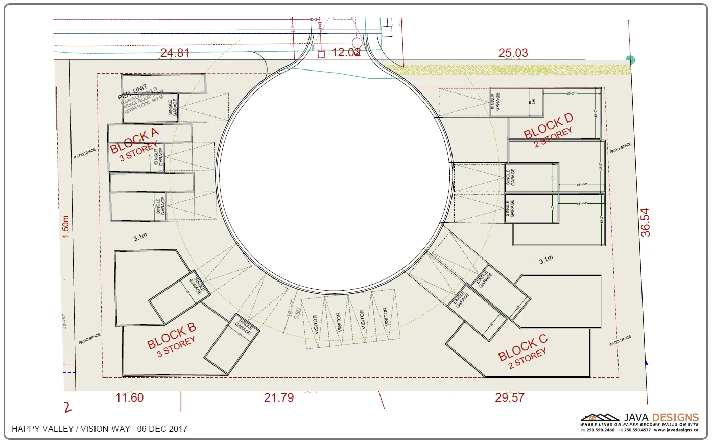
Site B: Eastern Portion of the Site
- Located at the rear of the property with access from a future extension of Vision Way.
- Proposed to contain approximately 10 townhouse units with shared visitor parking and landscaped areas, with individual accesses from the Vision Way cul-de-sac.
- Anticipated to be a maximum of three storeys and contain two parking spaces per unit (one in a ground level garage and one in a driveway).
- Preliminary site plan indicates four visitor parking spaces on Site B (in addition to three on Site A), in excess of visitor parking requirements.
Required Variances for 3427 Happy Valley Road
Even with the proposed amendments to the RM2A Zone, the proposed development will require variances to be constructed as currently designed. Given the relatively narrow width of the site and the requirement for a public cul-de-sac as the terminus of Vision Way, the applicant is requesting further reductions to the front, interior side, exterior side and rear setbacks to achieve the desired number of townhouse units.
Should Council view these reduced setbacks as appropriate, they may direct the Director of Planning to grant the requested variances through the required Form and Character Development Permit. Alternatively, Council may require the applicant design the site in conformity with the RM2A Zone.
Building and Site Design
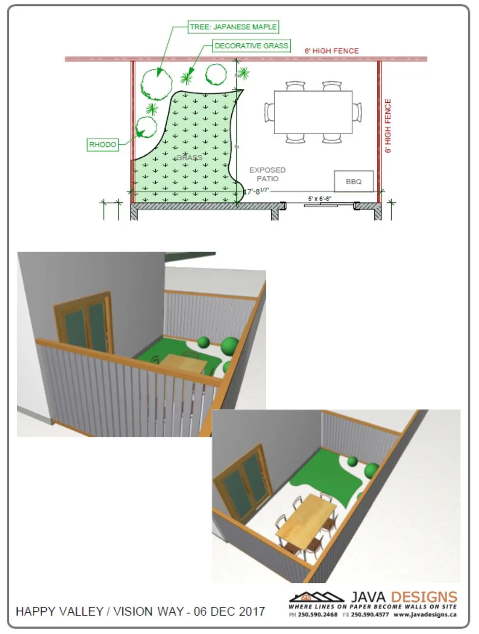
The applicant is in the process of finalizing townhouse designs. If rezoning approved, a Form and Character Development Permit addressing building elevations, site design and landscaping will be required prior to issuance of any Building Permits. Council could request a more detailed set of building plans prior to Public Hearing.
Table 3: Proposal Data
| Permitted by RR2 (Current Zoning) | Proposed by RM2A Amendments | Proposed at 3427 Happy Valley Road |
|---|---|---|
| Permitted Uses: • Accessory buildings & uses • Agriculture • Boarding kennel (> 4 ha) • Breeding kennel • Cemeteries • Golf Course • Group Day Care • Home Occupation • Intensive Agriculture (>4 ha) • One- or Two-Family Dwelling • Riding Academies/ Stables • Secondary Suites in a One-Family Dwelling • Temporary construction and real estate marketing offices • 4 Boarders in a One-Family Dwelling • Uses permitted by 3.01 |
• Accessory buildings & uses • Attached Housing • Home Occupation • Temporary construction and real estate marketing offices • Townhouses • Uses permitted by Section 3.01 |
• Townhouses |
| Min. Lot Area | 4 ha | 1,800 m2 |
| Min. Lot Width | N/A | 18 m |
| Max. Density | 1 residential building per lot + 1 one-family dwelling for farm employees | 0.75 FAR, 1.0 FAR with amenities, 1.5 FAR with underground parking |
| Max. Height | 10.5 m 12.0 m for agricultural use |
3 storeys |
| Max. Lot Coverage | N/A | 40% |
| Min. Front Setback | 7.5 m | 5.5 m |
| Min. Side Setback | 3.0 m | 5.5 m for garage on exterior side 5.5 m (exterior), 7.5 m from at least one interior side or rear lot line, and 3.0 m from the other interior side and rear lot lines |
| Min. Rear Setback | 10.0 m | 7.5 m from at least one interior side or rear lot line and 3.0 m from the other interior side and rear lot lines (as above) |
| Min. Parking | 2 per dwelling unit + 1 per secondary suite | 2 per dwelling unit + visitor |
Vehicular, Pedestrian and Cycling Network
- Site is located on Happy Valley Road, approximately 750 m (2,460 ft) north of Latoria Road and just over 1,000 m (3,280 ft) south of Sooke Road.
- Vehicular access to Site A via a private roadway off Happy Valley Road (proposed width 7.0 m / 23.0 ft).
- Vehicle access to Site B via a cul-de-sac at the end of Vision Way (future extension). Temporary access via existing easement/statutory right-of-way over 3419 and 3417 Happy Valley Road until Vision Way is extended.
- Fire Department recommended “No Parking” signs in the cul-de-sac due to limited radius not allowing on-street parking.
- Close proximity to the Galloping Goose trail system (pedestrian and cycling connectivity).
- Sidewalks and marked bike lanes on Happy Valley Road north and south of the site.
- Bus service: northbound stop for Route #54 directly in front of the site; southbound stop for Routes #48, 54 and 55 at Happy Valley Road and Turnstone Drive.
- Engineering Department notes:
- Full frontage improvements to Bylaw No. 1000 standards will be required. Council may secure these through a Section 219 Covenant to be registered on Title prior to Bylaw adoption, and require construction prior to Building Permit issuance or subdivision approval.
- A Traffic Impact Assessment (TIA) will be required to assess the impact of the proposed 16 townhouse units on Site A accessing Happy Valley Road via a private roadway. Council may require this Assessment, to the satisfaction of the Director of Engineering, prior to Public Hearing.
- A construction parking management plan may be required and secured through a Section 219 Covenant.
- Road dedication required along Happy Valley Road frontage. Council may require applicant provide a road dedication plan to the satisfaction of the Director of Engineering prior to Public Hearing and secure registration prior to subdivision approval or Building Permit issuance through a Section 219 Covenant.
Municipal Infrastructure
- Municipal water and sewer infrastructure installed along Happy Valley Road can serve the subject property. Services will be extended down Vision Way when constructed.
- Applicant must connect all units to municipal systems and is responsible for costs of installing services and any required extensions.
- Subdivision and Development Servicing Bylaw No. 1000 requires demonstration to satisfaction of Director of Engineering that stormwater can be managed on-site.
- Engineering Department requested a technical memo regarding stormwater management to the satisfaction of the Director of Engineering prior to Public Hearing.
- Council may require full stormwater management plan prior to subdivision approval or Building Permit issuance and secure via Section 219 Covenant.
- Applicant required to provide FUS calculations prior to Building Permit issuance (applicants encouraged to provide earlier).
Nuisances: Gun Range & Agriculture
Council may require a Section 219 Covenant registered on title advising future landowners that the development is located in proximity to ALR lands (general farm nuisances possible) and the South Vancouver Island (SVI) Rangers gun range (located less than a kilometer away) which may generate noise nuisances.
Financial Implications
Rezoning to permit higher densities may increase assessed value and municipal revenue. Applicant will connect to municipal sewers and complete frontage improvements; direct capital costs to municipality will be negligible.
Table 5 – Amenity Contributions
| Amenity Item | Contribution per SFE (South Langford) | Total Contribution (15.86 SFE) |
|---|---|---|
| General Amenity Reserve Fund | $6,000 per Single Family Equivalent (SFE) | $95,160 |
| Affordable Housing Reserve Fund | $1,000 per SFE | $15,860 |
| Total Amenity Contributions | $7,000 per SFE | $111,020 |
Table 6 – Development Cost Charges
| Development Cost Charge | Contribution per Unit | Total (26 units) |
|---|---|---|
| Roads | $3,985 per unit | $103,610 |
| Storm Drainage | $1,166 per unit | $30,316 |
| Park Improvement | $1,890 per unit | $49,140 |
| Park Acquisition | $1,100 per unit | $28,600 |
| Incremental Storage Improvement Fee | $371.25 per unit | $9,652.50 |
| Integrated Survey Area | $35 per parcel created | $0 |
| Subtotal (DCCs paid to City of Langford) | $8,512.25 per unit + $35 per parcel created | $221,318.50 |
| CRD Water | $2,323.43 per unit | $60,409.18 |
| School Site Acquisition | $558 per unit | $14,508 |
| Total (estimated) DCCs | $11,393.68 per unit + $35 per parcel created | $296,235.68 |
Options
Option 1
That the Planning, Zoning and Affordable Housing Committee recommend that Council:
- Give First Reading to Bylaw No. 1757 to amend the text of the RM2A (Attached Housing) Zone by:
(a) Deleting from the RR2 (Rural Residential 2) Zone and adding to the RM2A (Attached Housing) Zone the property legally described as Lot 3, Section 85, Metchosin District, Plan 6533, PID No. 005-857-643 (3427 Happy Valley Road).
(b) Replacing 6.31A.03(1) with “Except as provided in Articles (2) and (3), buildings in the RM2A Zone shall not exceed a floor area ratio of 0.75.”
(c) Replacing 6.31A.03(2) with “Despite Subsection 6.31A.03(1), on land whose legal description is set out in Table 1 of Schedule AD, the floor area ratio may be increased to a maximum of 1.0, if the owner of the land proposed to be developed pays to the City the amount specified in Column 4 of Table 1 of Schedule AD, prior to the issuance of a Building Permit.”
(d) Replacing 6.31A.03(3) with “Despite Subsection 6.31A.03(1), the floor area ratio may be increased to a maximum of 1.5 if the owner of the land proposed to be developed provides a minimum of 50% of the parking spaces required by this Bylaw in an underground or under building parking structure, subject to compliance with the density bonus provisions specified in Subsection 6.31A.03(2).
(e) Replacing 6.31A.06 with "No building or structure may be located:
a. Within 5.5 m (18 ft) of any front lot line;
b. Within 5.5 m (18 ft) of any exterior side lot line;
c. Within 7.5 m (25 ft) of at least one interior side or rear lot line, and within 3.0 m (10 ft) of the other interior side and rear lot lines.
Subject to the following terms and conditions:
(a) That the owner provides, as a bonus for increased density, the following contributions prior to the issuance of a Building Permit:
a. $3,660 per dwelling unit towards the General Amenity Reserve Fund; and
b. $610 per dwelling unit towards the Affordable Housing Reserve Fund.
(b) That the applicant provides, prior to Public Hearing:
a. A road dedication plan to the satisfaction of the Director of Engineering;
b. A technical stormwater management memorandum to the satisfaction of the Director of Engineering; and
c. A Traffic Impact Assessment, to the satisfaction of the Director of Engineering, to evaluate the impact of the proposed development on the western portion of the site on Happy Valley Road
(c) That the applicant provides, prior to Bylaw Adoption, a Section 219 covenant, registered in priority over all other charges on title, that agrees to the following;
a. That any required road dedication, in accordance with the road dedication plan approved by the Director of Engineering, will be registered prior to subdivision approval or Building Permit issuance, whichever occurs first;
b. That the developer will construct full frontage improvements in accordance with Bylaw No. 1000 and to the satisfaction of the Director of Engineering, prior to subdivision approval or Building Permit issuance, whichever occurs first;
c. That the developer will provide a construction parking management plan, to the satisfaction of the Director of Engineering, prior to Building Permit issuance;
d. That the developer will provide a stormwater management plan, in accordance with Bylaw No. 1000 and to the satisfaction of the Director of Engineering, prior to subdivision approval or Building Permit issuance, whichever occurs first;
e. That the developer will implement the approved stormwater management plan, and complete any required improvement and/or upgrades to on- and off-site infrastructure, to the satisfaction of the Director of Engineering and at the developer’s expense;
f. That the developer will implement any on- or off-site improvements required by the Traffic Impact Assessment, to the satisfaction of the Director of Engineering and prior to subdivision approval or Building Permit issuance, whichever occurs first; and
g. That the developer and all subsequent landowners acknowledge the proximity of the development to lands within the Agricultural Land Reserve (ALR) and to the South Vancouver Island (SVI) Rangers gun range, and acknowledge that these land uses may create noise, odour and general nuisances.
- Authorize the Director of Planning to issue the following variances in a Development Permit to be applied for by the applicant:
(a) To reduce the minimum front yard setback from 5.5 m (18 ft) to 3.0 m (10 ft) for a portion of the building other than the garage;
(b) To reduce the minimum exterior side yard setback from 5.5 m (18 ft) to 3.0 m (10 ft):
(c) To reduce the minimum interior side yard setback from 3.0 m (10 ft) to 1.5 m; and
(d) To reduce the minimum rear yard setback from 7.5 m (25 ft) to 3.0 m (10 ft).
OR Option 2
- Reject this application for rezoning.
Respectfully Submitted,
Submitted by:
Sarah Herring, MCIP, RPP, Planner II
Concurrence:
Matthew Baldwin, MCIP, RPP Director of Planning
Cory Manton, Manager of Parks and Recreation
Michelle Mahovlich, P.Eng, P.Geo, Director of Engineering
Leah Stohmann, MCIP, RPP, Deputy Director of Planning
Michael Dillabaugh, CPA, CA, Director of Finance
Braden Hutchins, Director of Corporate Services
Darren Kiedyk, Chief Administrative Officer
:sh
Appendices
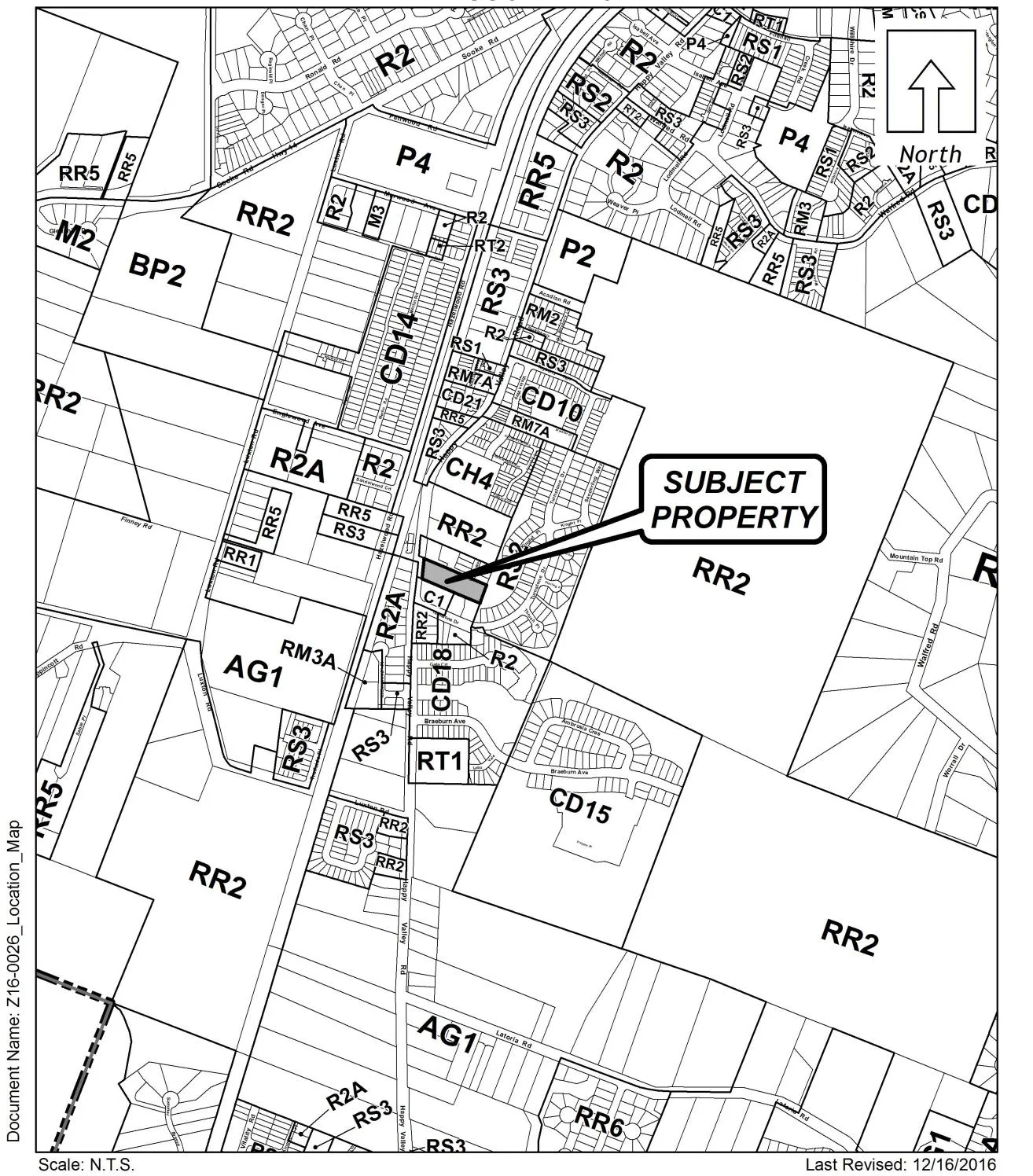
Appendix A – Location Map
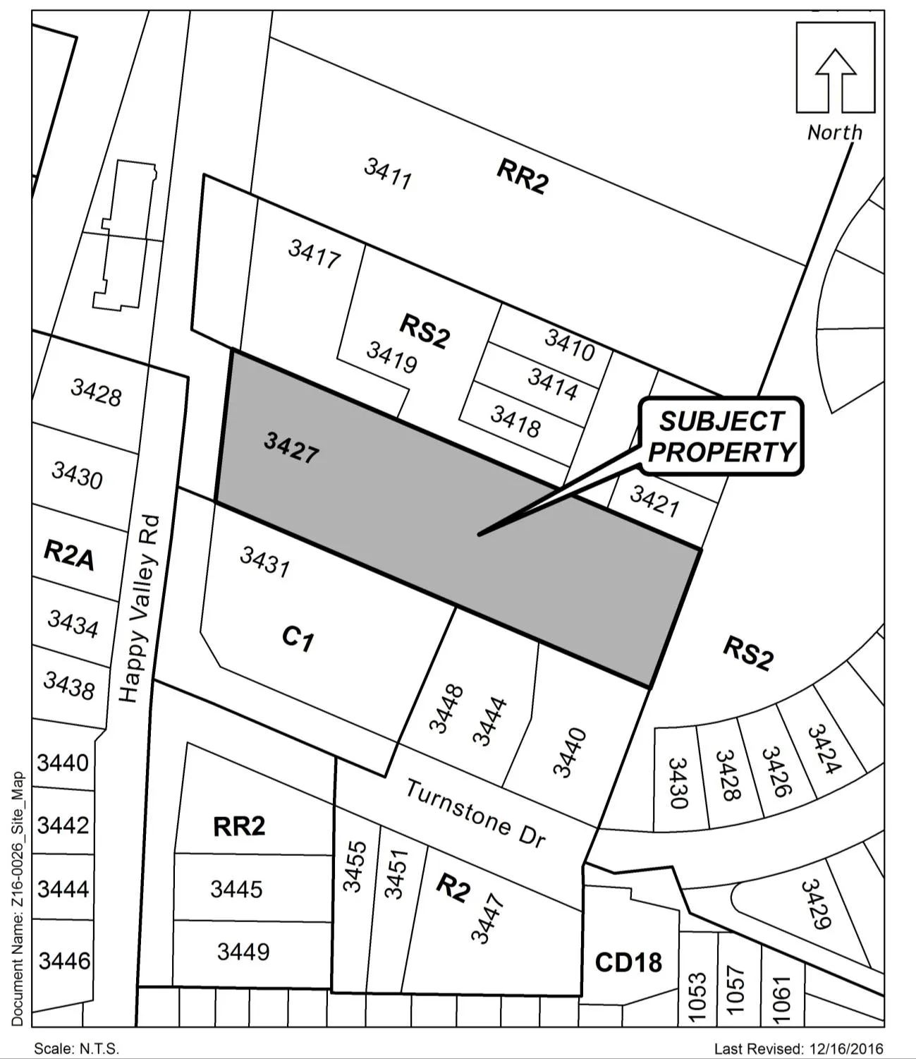
Appendix B – Site Map
Appendix C – Conceptual Site Plans