DocumentsStaff ReportMay 22, 2018Pages 22–36
Staff Report: OCP17-0002 / Z17-0016 – 866 Latoria Road (to PZAH Committee)
Planning staff report recommending that Council direct staff to prepare OCP and zoning bylaws to allow an 18-lot single-family subdivision and a 30-unit townhouse development at 866 Latoria Road, with specified amenity contributions and conditions.
Key facts
- Application: OCP17-0002 / Z17-0016 for 866 Latoria Road
- Proposal: 18 single-family lots and a 30-unit townhouse site
- Amenity contributions (Council policy): $6,000 per lot (General Amenity), $1,000 per lot (Affordable Housing), $3,660 per townhouse (General Amenity), $610 per townhouse (Affordable Housing)
- Applicant volunteered additional $136,000 towards General Amenity Reserve Fund
- Estimated DCCs subtotal to Langford: $433,664.50; Total estimated DCCs including CRD water and school: $555,573.52
Staff Report to Planning, Zoning and Affordable Housing Committee
Date: September 25, 2017
Department: Planning
Application No.: OCP17-0002 / Z17-0016
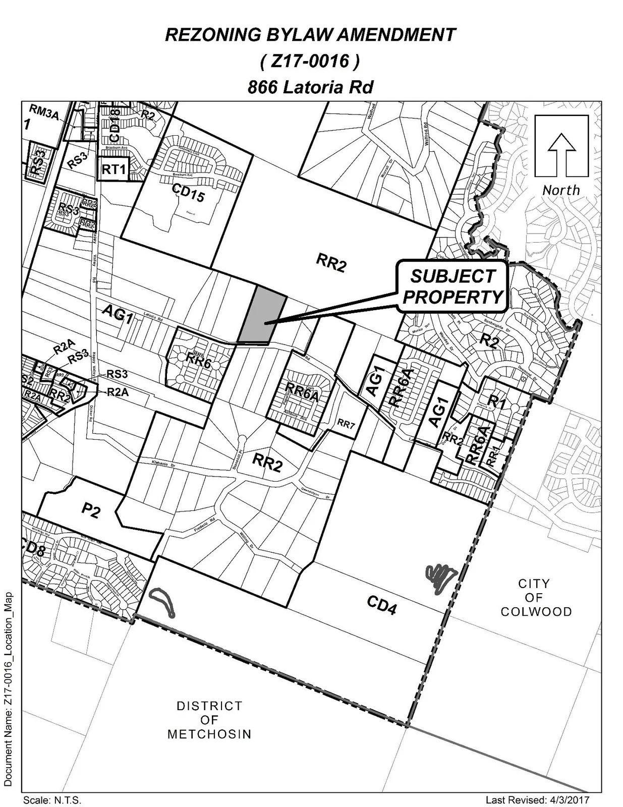
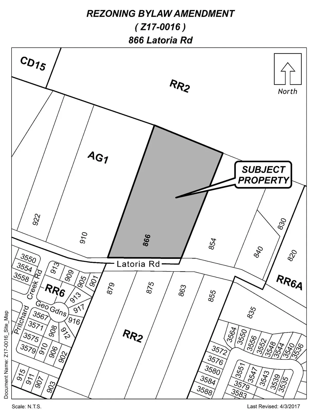
Subject: Application to amend the Official Community Plan designation for 866 Latoria from Agricultural Strategy Lands to Hillside or Shoreline and to rezone one portion of the lands from AG1 (Agriculture 1) to the RR6 (Rural Residential 6) Zone and another portion to the RM2A (Attached Housing) Zone to permit an overall development of 18 single-family lots and a 30-unit townhouse site.
PURPOSE
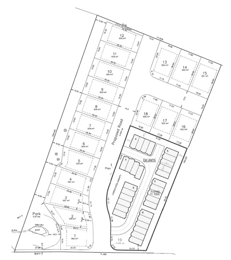
Irwin Consulting Ltd. has applied on behalf of Maureen and David Carter to amend the Official Community Plan designation of 866 Latoria from Agricultural Strategy Lands to Hillside or Shoreline and to rezone the lands from AG1 (Agriculture 1) to the RR6 (Rural Residential 6) Zone and the RM2A (Attached Housing) Zone to permit the development of 18 single-family lots and a 30-unit townhouse site.
The 18 single-family lots would have a minimum lot size of 500m2 (5,380ft2) and the townhouse site would have a maximum floor area ratio (FAR) of 1.25. The subject lands would include the dedication of a 2,700m² park along the western boundary line, which abuts ALR lands. While the subject lands are currently in the Agriculture Land Reserve, the Agricultural Land Commission has approved the land for exclusion subject to conditions described below.
BACKGROUND
PREVIOUS APPLICATIONS
ALR14-0003 - In 2014, an ALR application was submitted to exclude the subject property at 866 Latoria Road from the ALR. This application as well as three other ALR exclusion applications were considered by Council on June 26, 2015. Council passed the following resolution regarding these applications:
That Council:
- Establish, as policy, that a contribution to the Agriculture Fund shall be made as a bonus for increased density at the time of rezoning by any lands zoned AG1 (Agriculture 1) that have been removed from the ALR, and that this shall constitute a “benefit to agriculture” as described in Langford’s Official Community Plan;
- Direct staff to forward the ALR exclusion applications for the properties located at 3497 Happy Valley Road, 948, Latoria Road, 866 Latoria Road, and 3505 Happy Valley Road to the Agriculture Land Commission indicating that the City of Langford supports the exclusion of these lands from the ALR, subject to each applicant applying to rezone their land, through which Council will require $13.45 per m² of land as a bonus for increased density as a contribution to the City Agriculture Reserve Fund;
- Direct staff to engage owners of lands identified for possible exclusion from the ALR in the City’s Agricultural Strategy and make a block application for exclusion under Section 29 of the ALC Act on behalf of these property owners, and continue to engage in further dialogue with the Agricultural Land Commission pursuant to Councillor Szpak’s letter of March 27th, 2015, to pursue whether the block application or an Area Review of ALR land in Langford.
On May 17th, 2016, the ALC approved the exclusion of the subject property subject to the following condition: The City submitting for the Commission’s review and approval, an edge planning policy for the purpose of ensuring new development will not jeopardize the long-term use of adjacent ALR land for agricultural purposes.
Table 1: Site Data
| Item | Details |
|---|---|
| Applicant | Richard Irwin (Irwin Consulting Ltd.) |
| Owner | Maureen and David Carter |
| Civic Address | 866 Latoria Road |
| Legal Description | LOT 1, SECTION 70, METCHOSIN DISTRICT, PLAN 1957, PID 004-048-032 |
| Size of Property | 20,224m2 (5 acres) |
| DP Areas | Riparian, Potential Habitat and Biodiversity Values |
Current and Proposed Zoning / OCP
| Current | Proposed (RR6) | Proposed (RM2A) | |
|---|---|---|---|
| Zoning | AG1 (Agriculture 1) | RR6 (Rural Residential 6) with an amendment to make the minimum lot size 500m2 and allow secondary suites on lots of that size. | RM2A (Attached Housing) with an amendment to increase the FAR to 1.25 |
| OCP Designation | Agricultural Strategy Lands | Hillside or Shoreline | Hillside or Shoreline |
SITE AND SURROUNDING LAND USES
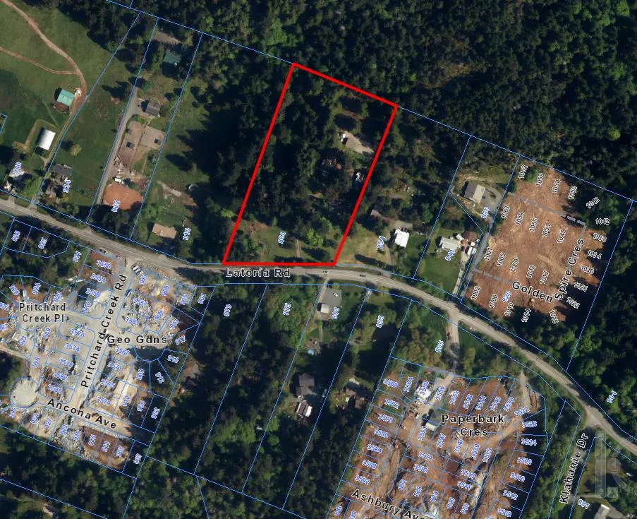
The subject property is primarily treed and contains a one-family dwelling and several accessory buildings. Surrounding properties are still quite large, ranging in size from 1.2ha to 27ha (3 acres to 68 acres), but development along Latoria Road is seeing newly created properties in the range of 500m² to 850m². Properties to the west are located within the ALR but are not active farming operations.
Table 2: Surrounding Land Uses
| Direction | Zoning | ALR | Use |
|---|---|---|---|
| North | RR2 (Rural Residential) | No | Vacant Land |
| East | RR2 (Rural Residential) | No | Residential |
| South | RR2 (Rural Residential) | No | Residential |
| West | AG1 (Agriculture 1) | Yes | Residential |
COUNCIL POLICY
Official Community Plan (OCP) Designation
The subject property is located within the Agricultural Strategy Lands OCP designation which has the following objectives:
- Objective 11.1 Promote and support community agriculture activities.
- Objective 11.2 Promote and support commercial agriculture as a viable business venture.
- Objective 11.3 Ensure development in or around farmlands does not preclude long term viability.
- Objective 11.3.3 As it relates to exclusion applications of farm lands from the Agricultural Land Reserve (ALR), the City will support exclusions provided there is considerable benefit that can be provided such as farmland dedications for community trust and/or upgrades to farming/ farmland infrastructure as part of exclusions.
While the subject property is shown on the OCP map as Agricultural Strategy Lands, those lands are defined on page 15 of the OCP as: Lands currently held in the Agricultural Land Reserve. According to Provincial Government law, municipalities are not permitted to apply an OCP designation to ALR lands that proposes future consideration of land use and growth. As the Agricultural Land Commission has agreed to exclude the subject property from the ALR once their conditions are met, the OCP designation would no longer be applicable. As such, Council may wish to amend the OCP map to designate the subject property to Hillside or Shoreline. Previously, Council supported a similar application at 935 Latoria Road.
Hillside or Shoreline — Predominantly existing low intensity settled areas throughout community with a high percentage of open space and undeveloped areas located on a hillside or near the shoreline.
- Predominantly residential precinct that supports a range of clustered low, medium and high density housing choices including secondary suites. Higher building forms, such as point towers, will be permitted on hillsides to maximize open space provided some conditions are satisfied
- Schools, community facilities and other institutional uses are permitted throughout the area
- Home-based businesses, live-work housing is encouraged; Home-based accommodations (e.g. Bed & Breakfasts) are permitted.
- Parks, open spaces and green corridors (creeks, wildlife corridors, trails, etc.) are integrated throughout the area. Large playfields are discouraged due to grading requirements. Site and topographic responsive pocket parks, enhanced viewpoints, graded hiking and walking trails, children's play areas, including, tot lots and outdoor exercise areas are strongly encouraged on hillside areas.
- This area allows for Neighbourhood Centres to emerge in the form of high and medium density clustered mixed-use nodes
Development Permit Areas
The subject property is located within both the Riparian and Potential Wildlife Habitat and Biodiversity Development Permit Areas. Prior to alteration of land, the applicant will need to apply for and obtain a Development Permit that addresses both these DP areas. The applicant will also be required to provide a report prepared by a registered professional biologist to address the potential environmental sensitivities.
COMMENTS
Development Proposal
The applicant would like to amend the OCP designation of 866 Latoria Road from Agricultural Strategy Lands to Hillside or Shoreline and to rezone it from AG1 (Agriculture 1) to the RR6 (Rural Residential 6) Zone and the RM2A (Attached Housing) Zone in order to permit the development of an 18-lot subdivision and the creation of a 30-unit townhouse site.
The rezoning would include two site specific amendments to the RR6 Zone – one to reduce the minimum lot size from 550m² down to 500m² and the other to permit secondary suites on lots that are 500m² in size. An amendment is also be proposed on the RM2A Zone, which would see an increase to the maximum Floor Area Ratio (FAR) from 0.75 to 1.5. This amendment would apply to the RM2A Zone itself and would not be site specific as it has been noted with other townhouse developments in the RM2A zone that the FAR does not coordinate effectively with attached housing, which this zone permits.
If Council does not object to the proposal, the RR6 zone would be amended such that the minimum lot size would be 500m² and secondary suites on lots of that size would be permitted. This amendment would not impact the one other development that is zoned RR6 (935 Latoria) as it has already been subdivided and built upon.
Table 3: Proposal Data
| Topic | Permitted by AG1 (Current Zoning) | Proposed RR6 Zone | Proposed RM2A Zone |
|---|---|---|---|
| Permitted Uses | - Various large-lot uses (kennels, riding academies and stables, agricultural uses, cemeteries, golf courses) - Group day care; - One-family dwellings; - Two-family dwellings; - Secondary suites within one-family dwellings; - A maximum of 4 borders |
- One-family dwellings - Accessory buildings - Home occupation - A maximum of 4 borders - Secondary suite in the principle building or in a detached accessory building (but not in both) |
- Attached housing - Accessory buildings - Home occupation - Townhouses |
| Density (min. lot size or FAR) | 4 ha | 550 m2 (proposed to be amended to 500 m2) | 0.5 FAR (up to 0.75 if 50% of parking is under building) (proposed to be amended to 1.0 FAR and up to 1.5 with under building parking) |
| Lot Width | n/a | 14m | N/A |
| Height | 10.5m | 9m | 9m |
| Site Coverage | n/a | 50% | 35% |
| Front Yard Setback | 7.5m | 4.5m to the building, but 5.5m to the garage | 7.5m* (3.0m proposed) |
| Interior Side Yard Setback | 3.0m | 1.5m | 6m* (5.5m proposed) |
| Exterior Side Yard Setback | 3.0m | 3m | 7.5m* (3.0m proposed) |
| Rear Yard Setback | 10m | 5.5m | 10m* (5.5m proposed) |
| Parking Requirement | - 2 spaces per one-family dwelling; - 3 spaces per two-family dwelling unit; - 1 space per secondary suite; |
- 2 spaces per one-family dwelling and one additional space if the house contains a secondary suite | - 3 spaces per dwelling unit OR 2 spaces per dwelling unit when a minimum of 1 on-street parking space per every 3 units is created within frontage of the subject property |
*Variance Required
As indicated in Table 3 above, the current proposal does not comply with the setback requirements of the RM2A Zone. The development would require variances for all four setbacks. If Council is supportive of the proposed setbacks, they may wish to authorize the Director of Planning is[sic] issue them in the required DP.
Zone Amendment
Also noted in Table 3 above, the proposed development does not comply with the minimum lot size for the RR6 Zone, nor does it comply with the FAR of the RM2A Zone. If Council is supportive of the proposed amendments, they may wish to modify the RR6 Zone for this property, and modify minimum FAR requirements of the RM2A Zone to better suit townhouse or attached housing proposals.
Net Increase to Agriculture
Previously, when Council passed a resolution regarding the proposed ALR exclusion of this property and for other properties in the vicinity, they also passed a resolution for staff to establish a policy requiring the owner of land that is excluded from the ALR to provide $13.45 per m² of their land towards an Agricultural Reserve Fund as a condition of rezoning. Currently, this policy has not yet been established.
This is the first rezoning application received for a property approved for exclusion from the properties supported for ALR exclusion. If Council still wishes to proceed with the forthcoming policy of requesting $13.45 per m², it would be in addition to the standard amenity contributions. The owner, however, has volunteered an amenity contribution in the amount of $136,000, which works out to $6.72 per m². This would be put towards the General Amenity Fund as the Agricultural Reserve Fund does not exist anymore.
Agricultural Buffer / Park Space / Wildlife Corridor
The applicant is proposing to dedicate 2,700m2 of Park space along the western side of the property and build a small meandering recreational trail for the following reasons:
- Council’s Agricultural Strategy suggests that lands adjacent to agricultural uses should consider edge planning to provide a buffer to agricultural lands.
- The ALC has also required as a condition of exclusion that the City develop an agricultural edge planning policy for the Commission’s review and approval, and the proposed Park can serve this purpose.
- Council Policy (shown below) encourages wildlife corridors and pedestrian trails in the South Langford Area, which the proposed Park space and trail would provide.
SLNP - Section 5.1 GREENWAYS AND OPEN SPACE
The opportunity to create wildlife corridors and natural greenways was given careful consideration in the preparation of this (SLNP) plan. Maintaining connectivity between Triangle Mountain and the southern end of the municipality for wildlife can be accomplished through the land use and density designations of lands on Triangle Mountain, along Latoria Road and in the Klahanie Estates.
SLNP - Section 5.1.1 Council will continue to seek opportunities, as lands develop in accordance with this plan, to create greenways and preserve open spaces for both active and passive recreational uses and identified environmental needs;
The proposed Park is within the Riparian development permit area and the applicant is proposing to fence both sides, retain and replant trees to enhance the ecology, and build a low maintenance (gravel) walking trail that will be approximately 2.0m wide meandering through the Park. All of this would be completed under the guidance and monitoring of the project ecologist through the Development Permit process.
This Park can be secured as a condition of zoning, and include that the applicant provide an arborists report prior to subdivision approval to provide a tree protection plan, and to remove any hazardous trees prior to dedication.
Nuisances: Gun Range & Agriculture
As a condition of rezoning, it has been the typical practice in South Langford for applicants to provide a Section 219 covenant that informs future landowners that they border ALR lands, which could generate general farm nuisances, and that they are located near the South Vancouver Island Rangers gun range that also may generate general noise nuisances associated with a gun range.
Frontage Improvements
The applicant will be required to provide full frontage improvements in accordance with Bylaw 1000, as a condition of subdivision.
Greenspace and Treed Buffer along Latoria Road
While Council has not directed staff to draft a policy or bylaw, they have expressed interest in retaining a green buffer of trees along Latoria Road, aiming for a target of approximately 30% in the vicinity. Recently, Council has approved several rezoning applications along Latoria and Klahanie with this approximate level of greenspace.
There were several variables that determined the different percentages of each project. For example, some lots had large swaths of riparian area that were required to be protected under the Provincial Government’s Riparian Areas Regulations. Some projects provided additional cash-in-lieu of greenspace, while other projects provided non-disturbance covenants in privately owned yards. This last method did not provide as much protection as originally thought, as much of these privately owned yards were cleared of trees throughout site preparation.
The proposed Park along the western edge of this project would provide just over 13% of greenspace, but it would be entirely protected as it would be dedicated to the City, have a recreational trail built within it by the developer, including a footbridge. It is estimated that the amount of work to be completed within the Park will total over $10,000, all of which will be turned over to the City. Additionally, the only area of this property along Latoria that has trees is proposed to be dedicated as Park. Between the amount of Park dedication and works that will occur within it, Council may consider this sufficient in terms of providing a green buffer of trees.
SEWERS
A sewer main exists along the Latoria and the developer will be required to extend the main into the site, through approved civil engineering drawings. Any sewer extensions or modifications within the municipal road right-of-way will be constructed by West Shore Environmental Services at the applicant’s expense.
Drainage and Stormwater Management
As a condition of subdivision approval, Bylaw No 1000 requires that the applicant demonstrate storm water can be managed on-site through detention for the 2- and 10-year storm events, as well as correspond with the overall recommendations set out in the South Langford Drainage Study.
Neighbourhood Consultation
The developer has spoken with the adjacent neighbours as they would be impacted the most, but door-to-door canvassing of the larger neighbourhood has not occurred given how large and spread out the properties are. The Planning Department has not yet received any feedback.
Financial Implications
Rezoning the subject property to permit a higher density of development will increase the assessed value of lands and the eventual subdivision will increase municipal revenue due to the number of lots created. As the developer is responsible to complete all frontage improvements along Latoria and build the new road, the direct capital costs to the municipality associated with this development will be negligible.
FINANCIAL CONTRIBUTIONS
Council’s Amenity Contribution Policy
The amenity contributions that apply as per Council’s Affordable Housing, Park and Amenity Contribution Policy are summarized in Table 4 below.
Table 4 – Amenity Contributions per Council Policy*
| Amenity Item | Per Unit Contribution | Total |
|---|---|---|
| Affordable Housing Reserve Fund | $1,000 per lot | $18,000 |
| $610 per townhouse | $18,300 | |
| General Amenity Reserve Fund | $6,000 per lot | $108,000 |
| $3,660 per townhouse | $109,800 | |
| Total | $254,100 |
*The applicant will be charged for new lots created at the time of subdivision, and for the townhomes at the time of building permit issuance.
Please note that the applicant has also proposed to contribute an additional $136,000 towards the General Amenity Reserve Fund.
Table 5 – Development Cost Charges*
| Development Cost Charge | Per Unit Contribution | Total |
|---|---|---|
| Roads | $6,056 per lot | $109,008 |
| $3,188 per townhouse | $95,640 | |
| Storm Drainage | $1,878 per lot | $33,804 |
| $1,166 per townhouse | $30,980 | |
| Park Improvement | $1,890 per lot | $34,020 |
| $1,890 per townhouse | $56,700 | |
| Park Acquisition | $1,100 per lot | $19,800 |
| $1,100 per townhouse | $33,000 | |
| ISIF Fees | $495 per lot | $8,910 |
| $371.25 per townhouse unit | $11,137.50 | |
| Integrated Survey Area | $35 per lot | $665 |
Subtotal (DCCs to Langford): $433,664.50
CRD Water:
- $2,655.34 per lot — $47,796.12
- $1,493.63 per townhouse — $44,808.90
School Site Acquisition:
- $698 per lot — $12,564
- $558 per townhouse — $16,740
TOTAL (estimate) DCCs: $555,573.52
*The applicant will be charged per new lot/unit created at the time of subdivision or building permit, totaling $14,807.34 per new lot and $9,766.88 per new unit.
OPTIONS
OPTION 1
That the Planning, Zoning and Affordable Housing Committee recommend that Council:
Direct staff to prepare a bylaw to amend the Official Community Plan of the subject property at 866 Latoria Road form Agricultural Strategy Lands to Hillside or Shoreline;
Direct staff to prepare a bylaw to amend the zoning designation of the property located at 866 Latoria Road from AG1 (Agriculture 1) to RR6 (Rural Residential 6) and RM2A (Attached Housing) subject to the following terms and conditions:
a) That the applicant agrees to provide, as a bonus for increased density, the following contributions per one-family lot created, prior to subdivision approval: i. $6,000 towards the General Amenity Reserve Fund; and ii. $1,000 towards the Affordable Housing Reserve Fund.
b) That the applicant agrees to provide, as a bonus for increased density, the following contributions per townhouse unit created, prior to building permit issuance: i. $3,660 towards the General Amenity Reserve Fund; and ii. $610 towards the Affordable Housing Reserve Fund.
c) That the applicant agrees to provide, as a condition of removing land from the ALR, the following contribution, prior to subdivision approval: i. $136,000 towards the General Amenity Reserve Fund.
d) That the applicant provides, prior to Bylaw Adoption, a Section 219 covenant, registered in priority of all other charges on title, that agrees to the following: i. That a 2.0m wide road dedication be provided along Latoria Road; ii. That a 15m wide road dedication be provided for the proposed new road; iii. That all frontage improvements to Bylaw 1000 standards are provide to the satisfaction of the Director of Engineering; iv. That all municipal works and third party utility services are installed within municipal road dedication; v. That a storm water management plan be provided, which demonstrates the required onsite detention, to the satisfaction of the Director of Engineering; vi. That notification be provided that the properties are close to agricultural operations and the South Vancouver Rangers property, both of which may generate nuisances; vii. That a tree protection plan, and the removal of any hazardous trees, is provide prior to subdivision approval. viii. That the Park area shown on Appendix A of this report is dedicated to the City at the time of subdivision and that the applicant completes improvements within this Park to the satisfaction of the Parks Manager.
- Direct staff to prepare a zoning bylaw amendment to the RR6 (Rural Residential 6) Zone as per the following:
a) By replacing 6.15.01(5) with, “secondary suite within a one-family dwelling or within an accessory building on lots 500m² or greater and in accordance with Section 3.08.” b) By replacing 6.15.02(4) with, “Notwithstanding Subsection 6.15.02(1), on land whose legal description is set out in Table 1 of Schedule AD, the minimum parcel area for subdivision may be 500 m² (5,382 ft²) if the owner of the land proposed to be subdivided: a. pays to the City the amount specified in Column 4 of Table 1 of Schedule AD, prior to the time of subdivision.”
- Direct staff to prepare a zoning bylaw amendment to the RM2A (Attached Housing) Zone as per the following:
a) By replacing 6.31A.03(1) with, “Except as provided in articles (2) and (3), buildings in the RM2A Zone shall not exceed a floor area ratio of 0.75;” b) By replacing 6.31A.03(2) with, “Notwithstanding subsection 6.31A.03(1), on land whose legal description is set out in Table 1 of Schedule AD, the floor area ratio may be increased to 1.0, if the owner of the land proposed to be developed: (Bylaw No. 1320) a. pays to the City the amount specified in Column 4 of Table 1 of Schedule AD, prior to issuance of a building permit.” c) By replacing 6.31A.03 with, “Notwithstanding the floor area ratio specified in subsection 6.31A.03(2), the floor area ratio may be increased to 1.5 if the owner provides 50% of the parking spaces required by this Bylaw in an underground or under building parking structure, subject to compliance with the density bonus provisions specified in Subsection 6.31A.03(2).”
Direct staff to forward the proposed subdivision plan and buffering plan to the Agricultural Land Commission and request that they accept the proposed plans as satisfying their agricultural edge planning condition for ALR exclusion.
Authorize the Director of Planning to issue the following variances within the required Development Permit for 866 Latoria Road:
a) That Section 6.31A.06(1) be varied to reduce the minimum front yard setback to 3.0m (13 ft); b) That Section 6.31A.06(2) be varied to reduce the minimum interior side yard setback to 5.5m (18 ft); c) That Section 6.31A.06(3) be varied to reduce the minimum exterior side yard setback to 3.0m (13 ft); and d) That Section 6.31A.06(4) be varied to reduce the minimum rear yard setback to 5.5m (18 ft).
OR
OPTION 2
- Reject this application for rezoning.
Respectfully Submitted
Submitted by:
Robert Dykstra, MCIP, RPP, Planner
Concurrence:
Matthew Baldwin, MCIP, RPP, Director of Planning
Cory Manton, Deputy Manager of Parks and Recreation
Michelle Mahovlich, P.Eng, P.Geo, Director of Engineering
Leah Stohmann, MCIP, RPP, Deputy Director of Planning
Michael Dillabaugh, Director of Finance
Braden Hutchins, Director of Corporate Services
Darren Kiedyk, Chief Administrative Officer
:rd
Appendix A – Proposed Development