DocumentsStaff ReportFeb 22, 2022Pages 19–26
Staff Report to the Planning, Zoning and Affordable Housing Committee — (OCP21-0002 & Z21-0016) (1300, 1289, 1277, 1265 & 1253 Valemount Court)
Planning staff report recommending proceeding with OCP amendment (Bylaw 1989) and rezoning (Bylaw 1990) of the Valemount Court properties to permit business park/light industrial uses, subject to technical and covenant conditions.
Key facts
- Report date: November 29, 2021
- Applicant: Niall Paltiel (Ascend Planning Ltd.)
- Owners listed for each parcel
- Site sizes: 1300 Valemount Court = 32,725 m2; other lots ~4,038–4,239 m2
- DP Areas: Fire Hazard, Steep Slopes, Habitat
Staff Report to the Planning, Zoning and Affordable Housing Committee — (OCP21-0002 & Z21-0016) (1300, 1289, 1277, 1265 & 1253 Valemount Court)
DATE
Monday, November 29, 2021
DEPARTMENT
Planning
APPLICATION NO.
OCP21-0002 & Z21-0016
SUBJECT
Bylaw No. 1990 – Application to Rezone 1300 Valemount Court from Attached Housing (RM2A) to Business Park – Sooke Road West (BP2A) and rezone 1289, 1277, 1265 and 1253 Valemount Court from Rural Residential (RR5) to Business Park – Sooke Road West (BP2A). Bylaw No. 1989 - Application to amend the Official Community Plan designation of the subject properties from Hillside or Shoreline to Business or Light Industrial to allow for business park type uses to be developed on the property.
PURPOSE:
Niall Paltiel of Ascend Planning Ltd. has applied on behalf of 1103097 BC Ltd. to rezone 1300 Valemount Court from Attached Housing (RM2A) to Business Park 2A (BP2A) and 1289, 1277, 1265, 1253 Valemount Court from Rural Residential (RR5) to Business Park 2A (BP2A), and to amend the Official Community Plan designation of the subject properties from Hillside or Shoreline to Business or Light Industrial to allow for business type uses to be developed on the property.
BACKGROUND:
PREVIOUS APPLICATIONS
Z17-0019: In 2017, a rezoning application was approved to rezone previously 1300 Glenshire Drive (1300 Valemount Court) from RR4 (Rural Residential 4) to RM2A (Attached Housing) to allow for the development of approximately 100 townhouse units on a private roadway.
Z98-0024: In 1999, a rezoning application was approved to rezone previously 1289 & 1300 Glenshire Drive (1289 & 1300 Valemount Court) from GB1 (Greenbelt 1) to GR1 (Greenbelt Residential 1) to permit a residential subdivision.
SITE DATA
Table 1: Site Data
| Item | Details |
|---|---|
| Applicant | Niall Paltiel (Ascend Planning Ltd.) |
| Owner | 1300 Valemount Court: 1103097 BC Ltd. (Matt Loken) |
| 1289 Valemount Court: Steven Humber | |
| 1277 Valemount Court: Paul Girouard | |
| 1265 Valemount Court: Lee and Tammy Simms | |
| 1253 Valemount Court: Lorrina and Wayne Sievewright | |
| Civic Address | 1300 Valemount Court |
| 1289 Valemount Court | |
| 1277 Valemount Court | |
| 1265 Valemount Court | |
| 1253 Valemount Court | |
| Legal Description | 1300 Valemount Court: Lot A Section 87 Metchosin District Plan EPP77127 (PID: 030-643-279) |
| 1289 Valemount Court: Lot 3 Section 87 Metchosin District Plan VIP72303 (PID: 025-020-625) | |
| 1277 Valemount Court: Lot 2 Section 87 Metchosin District Plan VIP72303 (PID: 025-020-617) | |
| 1265 Valemount Court: Lot 1 Section 87 Metchosin District Plan VIP72303 (PID: 025-020-587) | |
| 1253 Valemount Court: Lot A Section 87 Metchosin District Plan VIP71289 (PID: 024-841-269) | |
| Size of Property | 1300 Valemount Court: 32,725 m2 (8.08 acres) |
| 1289 Valemount Court: 4,239 m2 | |
| 1277 Valemount Court: 4,210 m2 | |
| 1265 Valemount Court: 4,094 m2 | |
| 1253 Valemount Court: 4,038 m2 | |
| DP Areas | 1300 Valemount Court: Fire Hazard, Habitat and Biodiversity, and Steep Slopes |
| 1289 Valemount Court: Fire Hazard | |
| 1277 Valemount Court: Fire Hazard | |
| 1265 Valemount Court: Fire Hazard and Steep Slopes | |
| 1253 Valemount Court: Fire Hazard and Steep Slopes | |
| Zoning Designation | 1300 Valemount Court: Attached Housing (RM2A) |
| 1289 Valemount Court: Rural Residential (RR5) | |
| 1277 Valemount Court: Rural Residential (RR5) | |
| 1265 Valemount Court: Rural Residential (RR5) | |
| 1253 Valemount Court: Rural Residential (RR5) | |
| OCP Designation | Hillside or Shoreline |
SITE AND SURROUNDING AREA
The subject properties are located in the western area of Langford, adjacent to the West Shore Parkway and near Sooke Road.
The majority of the properties are heavily forested with steep grading. Currently each property contains a one family dwelling and activities with rural residential properties are visible on the property.
The construction of the West Shore Parkway gives the property direct access from Valemount Court.
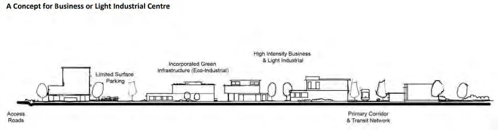
Table 2: Surrounding Land Uses
| Zoning | Use |
|---|---|
| North | CD3 — Vacant |
| East | CD3 — Vacant |
| South | M2 — General Industrial |
| West | BP2A/P4 — Business Park/Mount Wells Regional Park |
COMMENTS
OFFICIAL COMMUNITY PLAN
The current designation of the properties is Hillside or Shoreline that allows for residential and institional uses and that capitalizes on the shoreline access and sloping features of the site. The Hillside or Shoreline policy also requires that the property being developed retain 40% of the land as open space.
The developer wishes to amend the OCP designation of the subject property from the Hillside or Shoreline designations to the Business or Light Indsutrial designation. The Business or Light Industrial is an appropriate designation as it follows the developer’s intention to construct businesses allowed within the BP2A, that are predominantly light industrial with some small retail, offices and food service businesses allowed as well.
The OCP contains the following Policies and Objectives for lands designated as Business or Light Industrial Centre:
- Predominantly business and light industrial precinct that supports a range of business uses
- Parks, open spaces are integrated throughout the centre where appropriate to serve users and employees and green corridors (creeks, wildlife corridors, trails, etc.) that connect to other parts of the community where appropriate
- Transit stops are located where appropriate
Objective 3.25 – Ensure long term supply of employment lands
Policy 3.25.1 Develop and maintain an inventory of commercial and industrial floor space and remaining capacity to ensure that an adequate supply of employment lands is maintained.
Policy 3.25.2 Ensure long term availability of land for light industrial, commercial and/or institutional uses.
Policy 3.25.3 Promote high intensity business and light industrial development with smaller setbacks, smaller lots, multi-storey light industrial facilities.
DEVELOPMENT PERMIT AREAS
The subject property has been identified as being within two different Environmental Protection Development Permit Areas, and therefore an Environmental Impact Study or EIS, must be prepared by a professional registered biologist and submitted with a Development Permit application prior to any subdivision or site preparation. The site has also been designated as being within the Extreme High-Risk Fire DP Area, and will require a report from a certified forester, to accompany a Development Permit, to recommend mitigation practices to avoid an interface fire in the area. In addition, a form and character Development Permit is required as commercial and industrial uses are within the scope of Langford’s development permit areas. The developer can submit one Development Permit application that can address all these identified DP areas if the design style and site layout are known upfront.
PEDESTRIAN, CYCLING AND MOTORIST NETWORK
West Shore Parkway was completed in 2018 to provide a direct connection between the Trans-Canada Highway 1 and Sooke Road. The construction of West Shore Parkway also provided access to Valemount Court, that could previously only be accessed via a connection off Glenshire Road from Sooke Road. With the construction of the Parkway, this connecting portion of Glenshire Road was closed.
There is bus service along Sooke Road, the closest bus stop is BC Transit route 61 and 64. Route 61 brings riders from Sooke to downtown Victoria and back in the mornings and early evenings while route 64 serves the community of Sooke. Future development in this area may result in more BC Transit routes being added.
The Engineering Department has indicated a Traffic Impact Assessment (TIA) is required to determine the traffic volume and frequency difference between the current OCP designation (Hillside or Shoreline) to the proposed OCP designation (Business or Light Industrial). The TIA will be required prior to Public Hearing and to the satisfaction of the Director of Engineering.
FRONTAGE IMPROVEMENTS
With the completion of West Shore Parkway, the applicant will not be required to complete road frontage improvements.
INFRASTRUCTURE
Sewer runs within the West Shore Parkway road right of way and a pressurized main is extended within the Valemount Court road right of way. Any improvements or modifications needed to the sewer mains within the municipal road right-of-way will be constructed by West Shore Environmental Services at the developer’s expense.
The property is within the SSL Water Service Area and not serviced by the Capital Regional District (CRD) distribution system. The developer will be responsible for all connections and upgrades to services and sanitary systems needed to accommodate the proposed development, to the standards of the Subdivision and Servicing Bylaw No. 1000, and to the approval of the Director of Engineering. Council may wish to include a condition within a Section 219 covenant registered on the property to make the developer aware of this responsibility.
As mentioned, the property is within the Extreme Risk Fire Hazard DP Area. Langford Fire Rescue has no concerns regarding the rezoning, but will provide more comments with the review of a Development Permit. A detailed road network plan will be reviewed, at time of development permit, to determine compliance with applicable regulations concerning fire safety and fire fighting vehicle access.
As there is no on-site infrastructure to direct stormwater away from the property, the developer will be responsible to provide a stormwater management plan on how drainage to and from the site will be managed and stormwater captured and contained. A technical stormwater management memo, approved by the Director of Engineering, will be required prior to Council’s Public Hearing. A formal stormwater management plan, also approved by the Director of Engineering, will be required prior to the issuance of subdivision approval or a building permit to develop the site, whichever is first. The provision should be included within a Section 219 covenant registered on the property.
DEVELOPMENT PROPOSAL
The developer would like to capitalize on the property’s access to West Shore Parkway by constructing business park uses on the site that would benefit from the connection between the Trans-Canada Highway and Sooke Road. As the current zone does not support the proposed use, the developer wishes to rezone the properties from RM2A and RR5 zone to the BP2A (Business Park – Sooke Road West) zone. Additionally, the designated policy for the zone, Hillside or Shoreline also does not allow for the proposed business park uses and will have to be amended to the Business Park and Light Industrial OCP designation.
All commercial, business park and industrial development are required to obtain a form and character Development Permit prior to building permit. Site, building, elevation and landscaping plans will be provided at that time.
The property will have access off of West Shore Parkway, and an internal private road network is planning to be constructed to facilitate vehicle access on site.
Table 3: Proposal Data
| Item | Permitted by RM2A (Current Zoning) | Permitted by RR5 (Current Zoning) | Permitted by BP2A (Proposed Zoning) |
|---|---|---|---|
| Density (Min. lot size) | 1,800 m2 (0.5 ac) | 1 acre (0.4 ha) | 1,000 m2 (0.3 ac) |
| Height | Building/Structure: 3 stories | Building/Structure: 10.5 m (34.4 ft) | Building: 4 stories |
| Structure: 15 m (49.2 ft) | |||
| Site Coverage | 45% maximum | 60% maximum, 10% lot coverage on lots less than 1,000 m2 | |
| Front Yard Setback | 5.5 m (18 ft) | 7.5 m (24.6 ft) | • 4.5 m (14.8 ft) of any lot adjacent to Sooke Road |
| • 3 m (9.8 ft) of any lot line adjacent to a highway | |||
| • 3 m (10 ft) wide landscaping setback, or 2.5 m wide landscaping setback along the developed portion of each lot abutting a highway, or property zoned Agriculture, Residential or Institutional | |||
| Interior Side Yard Setback | 7.5 m (25 ft) of at least one interior side or rear lot line, and within 3 m (10 ft) of the other interior side or rear lot line | Within 3 m (9.8 ft) of any side lot line, except that no garage or carport whose vehicle access crosses an exterior side lot line may be located within 5.5 m (18 ft) of that exterior side lot line | |
| Exterior Side Yard Setback | 5.5 m (18 ft) | ||
| Rear Yard Setback | 7.5 m (25 ft) of at least one interior side or rear lot line, and within 3 m (10 ft) of the other interior side or rear lot line | 10 m (32.8 ft) of any rear lot line | |
| Parking Requirement | 2 per dwelling unit | 2 per dwelling unit | • 1 space per 45 m2 gfa for commercial uses |
| • Dependent on specific use for all industrial uses |
DEVELOPMENT COST CHARGES
Rezoning the subject properties to permit higher density of development will increase the assessed value of lands and eventually will increase municipal revenue due to the number of units created. As the developer is responsible to complete all frontage improvements, servicing connections and upgrades necessary to service the site, the direct capital costs to the City associated with this development will be negligible. A summary of Development Cost Charges that the developer will be expected to pay, is outlined in Table 4 below. Council should note that as industrial and commercial uses are being contemplated there are no Amenity contributions, as per Council’s Affordable Housing and Amenity Contribution Policy (POL-0011-PLAN).
Table 4 – Estimated Development Cost Charges (Payable at time of Building Permit issuance)
| Development Cost Charge | Per unit industrial | Per unit commercial |
|---|---|---|
| Roads | $7.97 m2gfa | $55.78/m2gfa |
| Incremental Storage Improvement Fees | $208 / 1000ft2 of floor area | $140 / 1000ft2 floor area |
| Integrated Survey Area | $35 per lot created | |
| CRD Water | $9.76/m2 | $5.29/m2 |
| School Site Acquisition | N/A | N/A |
OPTIONS:
Option 1
THAT the Planning, Zoning and Affordable Housing Committee recommend that Council:
Proceed with consideration of first reading of Bylaw No. 1989 to amend the policy designation within Langford’s OCP from Hillside or Shoreline Policy designation to the Business or Light Industrial Policy designation for the property located at 1300, 1289, 1277, 1265 and 1253 Valemount Court.
Proceed with consideration of first reading of Bylaw No. 1990 to rezone the property at 1300 Valemount Court from RM2A (Attached Housing) Zone to BP2A (Business Park – Sooke Road West) and rezone 1289, 1277, 1265 and 1253 Valemount Court from Rural Residential (RR5) to Business Park – Sooke Road West (BP2A), subject to the following terms and conditions;
a. That the applicant provides, prior to Public Hearing, the following:
i. A technical memo from an engineer that verifies storm water can be adequately managed on-site for the proposed developments, to the satisfaction of the Director of Engineering;
ii. A Traffic Impact Assessment (TIA) to determine the traffic volume and frequency difference between the current OCP designation (Hillside or Shoreline) to the proposed OCP designation (Business or Light Industrial), to the satisfaction of the Director of Engineering.
b. That the applicant provides, prior to Bylaw Adoption, a section 219 covenant, registered in priority of all other charges on titles, that agrees to the following:
i. That the developer will connect and be responsible for any upgrades, connections and installation of services and utilities required to support the proposed development, to the standards of Bylaw No. 1000 and to the satisfaction of the Director of Engineering;
ii. That a formal storm water management plan is submitted and implemented prior to issuance of a building permit or subdivision approval, whichever is first, and implemented, as per Bylaw 1000, all to the satisfaction of the Director of Engineering;
iii. That a construction parking and traffic management plan, prepared to the satisfaction of the Director of Engineering, be provided prior to the issuance of a building permit;
OR Option 2
That the Planning, Zoning and Affordable Housing Committee recommend that Council:
Take no action at this time with respect to Bylaw No. 1989.
Take no action at this time with respect to Bylaw No. 1990.
SUBMITTED BY: Matt Notley, Planner I
Concurrence:
Matthew Baldwin, MCIP, RPP, Director of Planning and Subdivision
Concurrence:
Michelle Mahovlich, P.Eng, P.Geo, Director of Engineering and Public Works
Concurrence:
Audrey Kryklywyj-Shortreid, Deputy Director of Finance
Concurrence:
Marie Watmough, Acting Director of Corporate Services
Concurrence:
Darren Kiedyk, Chief Administrative Officer
Related Documents
(3)Langford Zoning Bylaw, Amendment No. 630, (1253, 1265, 1277, 1289, 1300 Valemount Court)
Bylaw No. 1990 · Referenced in 2 sections
Langford Official Community Plan Bylaw, Amendment No. 45, (1253, 1265, 1277, 1289, 1300 Valemount Court)
Bylaw No. 1989 · Referenced in 2 sections
Subdivision and Development Servicing Bylaw
Bylaw No. 1000 · Referenced in 2 sections