DocumentsStaff ReportAug 21, 2023Pages 227–262
820, 822, 824, and 826 Hockley Ave Rezoning Application
Rezoning application materials and staff analysis for properties at 820–826 Hockley Avenue included for Council consideration.
Key facts
- Civic addresses: 820, 822, 824, 826 Hockley Avenue
- Included as Committee Resolutions item 8.6
- Pages: 227–262
820, 822, 824, and 826 Hockley Ave Rezoning Application
DATE: Monday, August 14, 2023
DEPARTMENT: Planning
APPLICATION NO.: Z22-0036
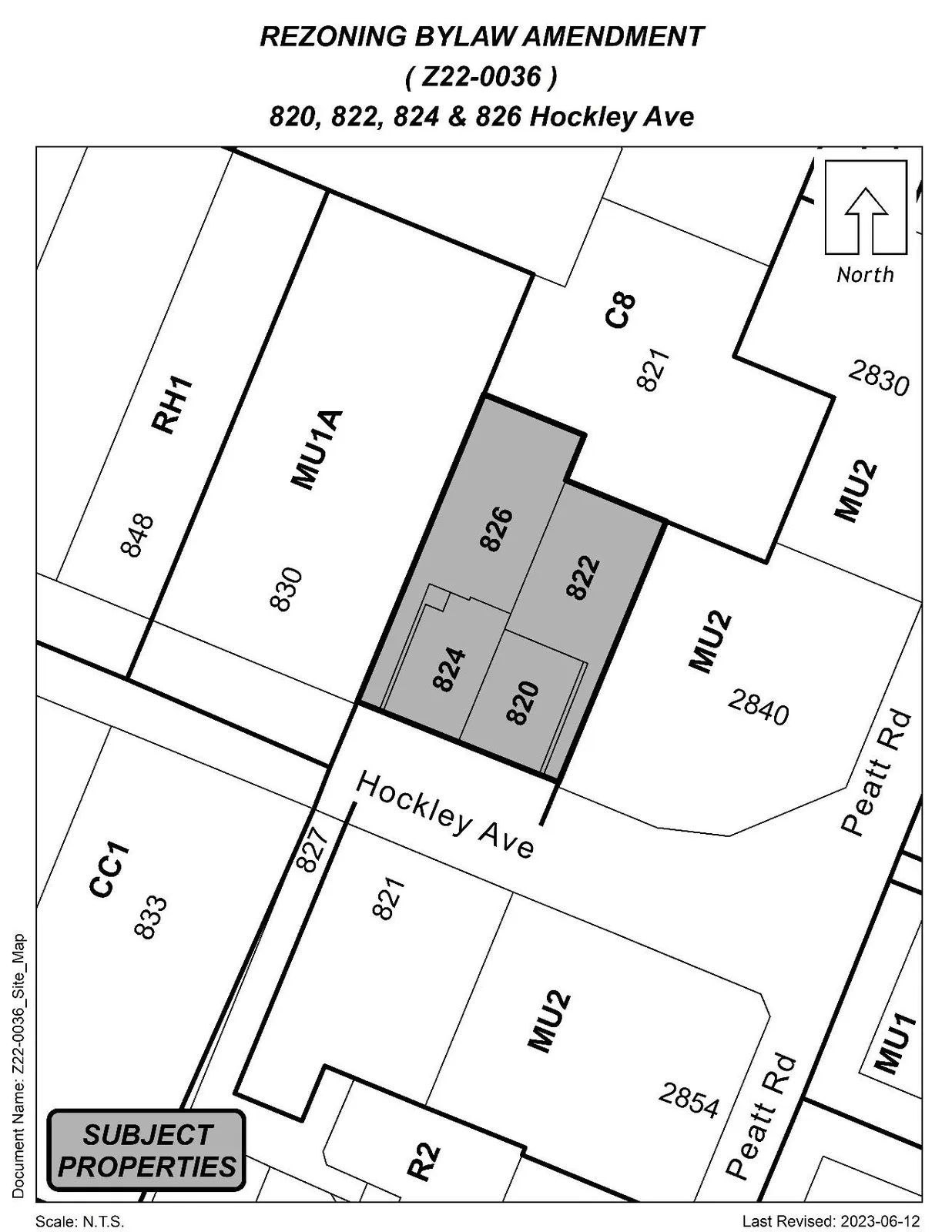
SUBJECT: Bylaw No. 2142 - Application to Rezone 820, 822, 824, and 826 Hockley Avenue from the R2 (One- and Two-Family Residential) Zone to the CC1 (City Centre) Zone to allow a six-storey apartment building.
Purpose
Rachael Sansom and Neil Banich have applied on behalf of Pioneer Luxury Homes Ltd, Mova Properties Corp, and The Hockley Development Ltd. to rezone 820, 822, 824, and 826 Hockley Avenue from R2 (One- and Two-Family Residential) to CC1 (City Centre) to allow a six-storey apartment building with approximately 75 units.
Background
Previous Applications
No previous applications have been made.
Table 1: Site Data
| Item | Details |
|---|---|
| Applicant | Rachael Sansom and Neil Banich |
| Owners | Pioneer Luxury Homes Ltd, Mova Properties Corp, and The Hockley Development Ltd. |
| Civic Address | 820, 822, 824, and 826 Hockley Avenue |
| Legal Description | STRATA LOTS A AND B SECTION 5 ESQUIMALT DISTRICT STRATA PLAN VIS3644 TOGETHER WITH AN INTEREST IN THE COMMON PROPERTY IN PROPORTION TO THE UNIT ENTITLEMENT OF THE STRATA LOT AS SHOWN ON FORM 1; and STRATA LOT 1 AND 2, SECTION 5, ESQUIMALT DISTRICT, STRATA PLAN VIS3260 TOGETHER WITH AN INTEREST IN THE COMMON PROPERTY IN PROPORTION TO THE UNIT ENTITLEMENT OF THE STRATA LOT AS SHOWN ON FORM 1, |
| Size of Property | 2,085 m2 (combined total) |
Development Permit Areas, Zoning, and OCP
- DP Areas: City Centre
- Zoning: Existing: R2; Proposed: CC1
- OCP Designation: Existing: City Centre; Proposed: City Centre
Site and Surrounding Area
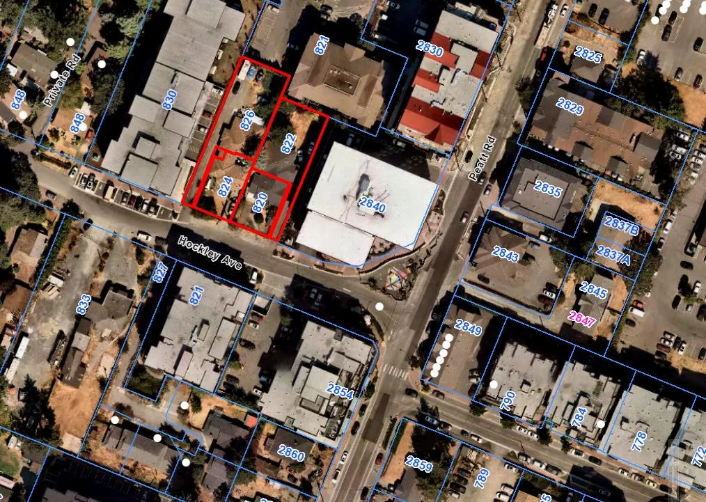
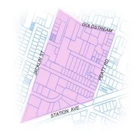
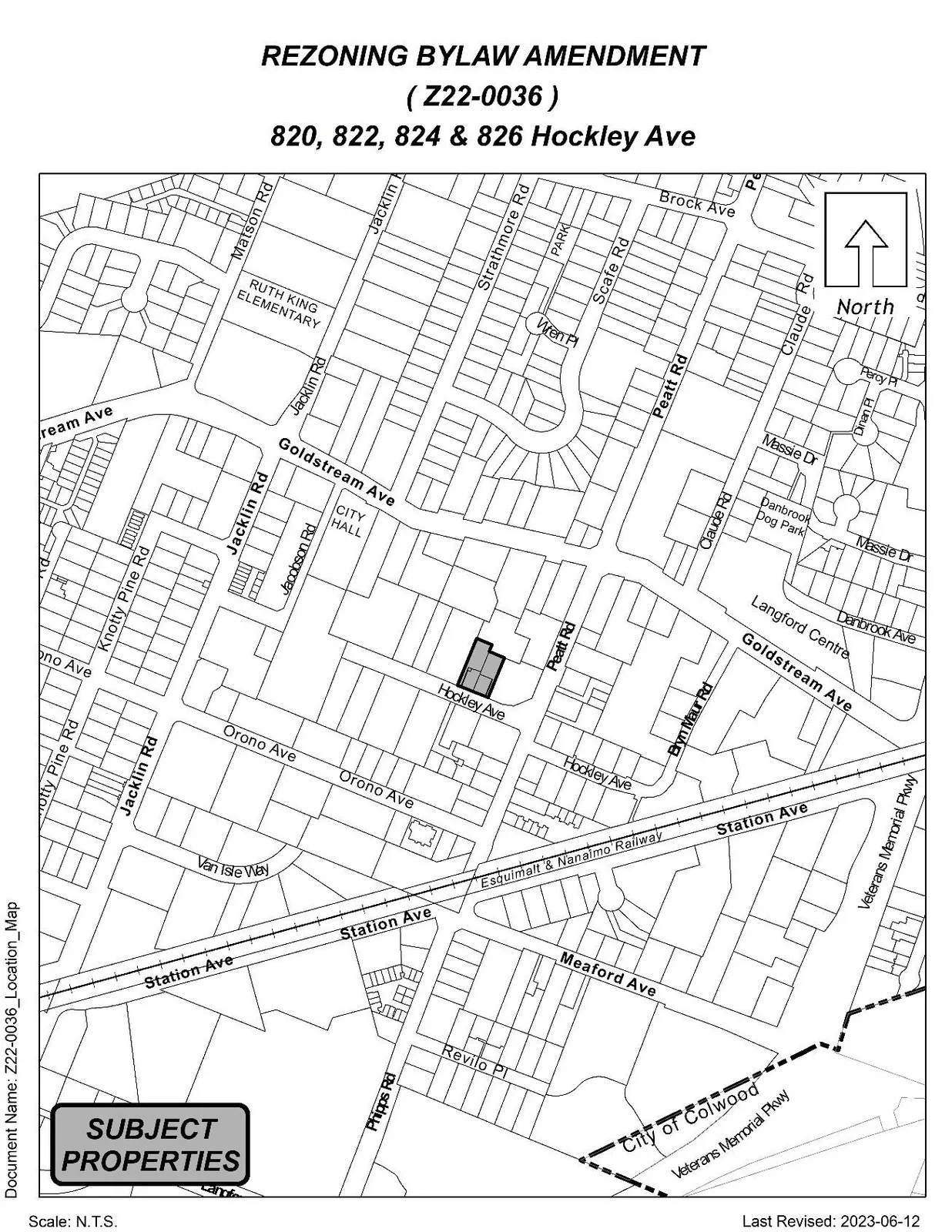
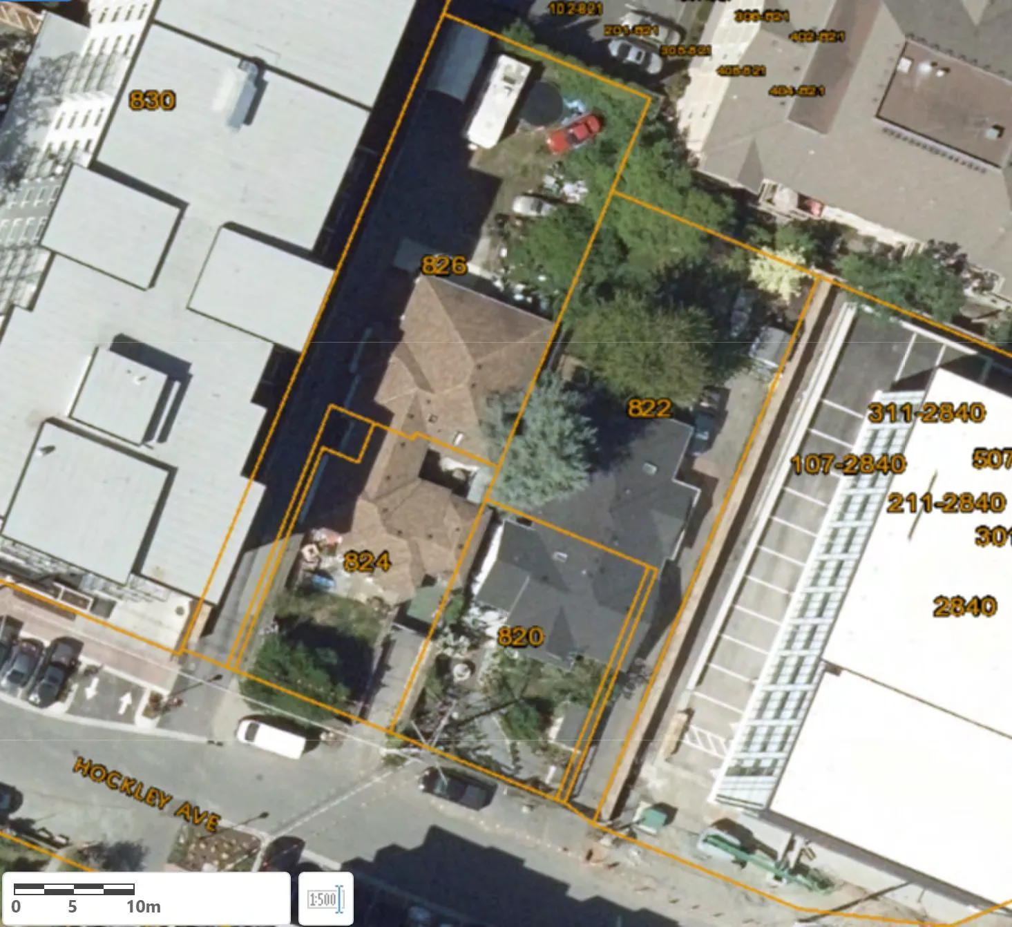
The subject properties are located within Langford’s City Centre, on the north side of Hockley Avenue near the intersection with Peatt Road. The lots are flat and contain two front/back style duplexes. Across the four lots, there are 5 trees and one large hedge that would be impacted by the development. The results of the arborist report will be discussed later within this report.
The surrounding area includes many apartment buildings between 4 – 12 storeys, with commercial ground floor activity occurring along Peatt Road. Additional shops, services, and transit connections are provided along Goldstream Avenue, approximately 250 m away. Danbrook Park, the nearest park, is approximately 500 m away, and the E&N Trail is approximately 300 m away.

Ruth King elementary school and Spencer middle school are within walking distance (approximately 700m and 1,200m, respectively). School District No 62 has been made aware of this application such that they can consider the proposed increase in density in this area as part of their long-range facility planning.
Table 2: Surrounding Land Uses
| Direction | Zoning | Use |
|---|---|---|
| North | C8 (Community Town Centre Pedestrian) | 4 Storey Apartment |
| East | MU2 (Mixed-Use Residential Commercial 2) | 5-storey Office and Retail |
| South | MU2 (Mixed-Use Residential Commercial 2) | 6-Storey Apartment |
| West | MU1A (Mixed-Use Residential Commercial A) | 6-Storey Apartment |
Council may wish to note that the above noted properties were rezoned before the creation of the CC1, CC2, and CCP zones which were specifically created for downtown development. Since the introduction of these zones, the above noted zones have not been utilized for new applications.
Council Policy
Official Community Plan
The Official Community Plan (OCP) Bylaw No. 1200 designated the subject properties as City Centre, which is defined by the following text:
- A major regional growth centre that support a wide range of high-density housing, including affordable and rental housing
- A major employment area for institutional, office, commercial, light industrial uses
- Major civic uses and public buildings are key landmarks
- A major place of community gathering and celebration
- A wide range of public squares, parks and open spaces are integrated throughout
- The City’s major entertainment and/or cultural precinct
- Inter-city and/or inter-regional transit hub connect residents
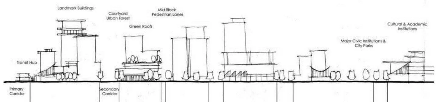
The proposal meets many objectives of the City’s OCP such as locating high intensity development in and around centres and near transit corridors, and provides ground floor units to ensure “eyes on the street” and active, street-oriented design.
Design Guidelines
The subject properties are located within the City Hall (S2) neighbourhood of the City Centre Design Guidelines. The CC1 Zone allows for 6-storey apartment buildings with optional ground floor commercial. As such, this proposal is consistent with the City Centre Concept Map. The applicant is proposing an entirely residential building, with no ground floor commercial units.
Development Permit Areas
The subject properties are not located within any of the Environmental Protection or Hazardous Area Development Permit Areas. However, these properties are located within the City Centre Development Permit Area and since the proposal is for a multi-family development, a Development Permit for Form and Character will be required prior to issuance of a building permit.
Low Carbon Concrete
In accordance with Council’s Low Carbon Concrete Policy POL-0167-PLAN, Council may wish to require the applicant to utilize ready-mix concrete that meets or exceeds the weighted average Global Warming Potential targets based on Concrete BC Baseline (average) mix data for the construction of the proposed development.
Attainable Housing Policy
The City’s Attainable Housing Policy requires all new developments with 4-storeys or more to participate in the program but does not set out specific requirements for purpose built rental buildings. On February 21st, 2023, Council passed a resolution to direct staff to add requirements for purpose-built rental buildings for Council’s consideration and to review individual proposals on a case-by-case basis in the interim, provided they meet a benchmark of including at least 10% of the units in a building for at least 10% below market rent. The applicant has committed to providing at least 10% of the units at 10% below market rate, or otherwise meet the City’s current Attainable Home Ownership Policy in the event they proceed with a condo building. Council may wish to require the applicant to enter into a Housing Agreement securing the units prior to the issuance of a building permit. The specific units will be confirmed through the development permit process.
Commentary
Development Proposal
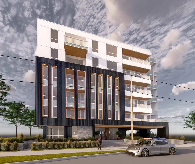
The applicant has applied to rezone 820, 822, 824, and 826 Hockley Avenue from R2 (One- and Two-Family Residential) to CC1 (City Centre) to allow for a six-storey apartment building with approximately 75 units.
- Unit mix proposed: 7 studios, 10 one-bedrooms, 30 one-bedrooms with den, and 28 two-bedrooms.
- All proposed ground floor units facing Hockley Avenue have individually accessed entrances from the street to meet the CC1 zoning requirement to have a minimum of 80% active building frontage.
- Each unit has a private balcony.
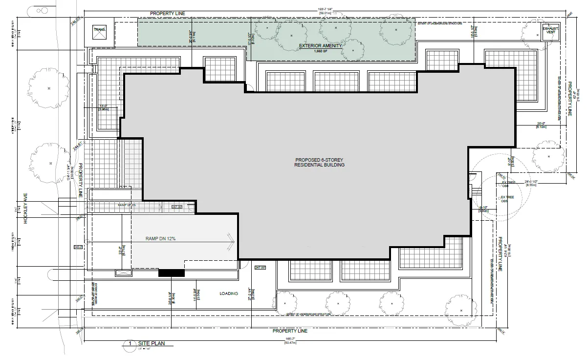
- Common outdoor amenity area: 154 m2 on the ground floor west side (~7% of lot area) intended for seating and pet activities.
- Applicant intends this as a purpose-built rental building and is committing to attainable rental units; Council may wish to waive typical requirement to strata-title the building.
Materials proposed: predominantly black corrugated metal and white cementitious panels, stone accents on ground floor, wood-toned composite metal trim and soffits.
Parking
- Applicant requests variance: reduce parking from 1.25 spaces/unit to 1.2 spaces/unit — provision of 90 stalls instead of required 94 stalls.
- Loss of 4 stalls due to protecting two off-site Garry Oak trees that would be impacted by underground parking excavation.
- Proposed: one space per unit (75) + 15 visitor stalls.
- Council may wish to authorize the Director of Planning to issue this variance within the development permit.
- Zoning Bylaw requires residential parking stalls include conduits for Level 2 EV charging (no separate rezoning condition required).
- Council may require covenant ensuring residential parking is not provided in exchange for compensation separate from residential unit.
- Bicycle parking provided: 1 per unit (75).
Table 3: Proposal Data
| Item | Permitted by R2 (Current Zoning) | Permitted by CC1 (Proposed Zoning) | Proposed by Rezoning Application |
|---|---|---|---|
| Permitted Uses | One or Two-Family Dwelling; Group Day Care; Home Occupation | Apartment; Office; Restaurant; Retail Store | Apartment |
| Density (FAR and/or min. lot size) | n/a | 5.0 FAR | 2.75 |
| Height | 9 m | 6-storeys | 6-storeys |
| Site Coverage | 35% | n/a | 47% |
| Front Yard Setback | 6 m | 2 m - 1-2 storeys; 4 m - 3+ storeys | 4.28 m – all storeys |
| Interior Side Yard Setback | 1.5 m | 3 m | 5.63 m – west side; 6.3 m – east side |
| Exterior Side Yard Setback | 4.5 m | 2 m - 1-2 storeys; 4 m - 3+ storeys | N/A |
| Rear Yard Setback | 6 m | 3 m | 3 m |
| Vehicle Parking Requirement | 2 per unit + 1 per secondary suite | 1.25 per 0-2 bedrooms; 2.25 per 3+ bedrooms | 1.2 per unit* all 0-2 bedrooms, no 3+ bedrooms |
| Bicycle Parking Requirement | n/a | 1 per unit | 1 per unit (75) |
*Variance requested
Trees / Arborist Report Summary
As part of the application, the applicant submitted an arborist report that examined:
- 5 on-site trees
- 2 municipal trees
- 16 off-site trees within influencing distance
Findings:
- 16 off-site trees and 2 municipal trees can be protected and maintained throughout construction (with mitigation).
- All 5 on-site trees (Cherry (1), Plum (2), Atlas Cedar (1), Garry Oak (1)) and a large cedar hedge will need to be removed to accommodate the proposed development and underground parking.
- Applicant modified proposal to avoid impact on two Garry Oak trees on neighboring property.
- Council may require applicant to implement tree protection and monitoring measures outlined by the arborist throughout construction.
Landscape concept: applicant provided plan to plant approximately 12 new trees on site, boulevard trees, and a six-foot privacy fence along side/rear property lines.
Multi-Modal Network
Frontage Improvements
- Frontage improvements required to meet Bylaw No. 1000 standards: red brick sidewalk and street parking.
- No road dedication requested.
- Parks Department requested Section 219 Covenant to secure owner’s maintenance of boulevard landscaping from back of sidewalk.
Pedestrian, Cycling and Motorist Network
- Sidewalk in front of building will be installed, filling gap between 830 Hockley Avenue and 2840 Peatt Road.
- Peatt Road has bike lanes; connects to E&N Trail and Galloping Goose trail for protected cycling access.
- Project is close to multiple MODO car share vehicles.
- No Traffic Impact Assessment requested; City’s Master Transportation Model accounts for this density.
- Director of Engineering requested no occupancy permit until roundabout at Peatt and Hockley Road is completed.
- Ministry of Transportation and Infrastructure: no objections.
- BC Transit: expressed support.
Infrastructure
Drainage and Stormwater
- Applicant submitted stormwater technical memo; reviewed and approved by Director of Engineering.
Sewers
- Sewer main along Hockley Avenue; building connection required. Any improvements/extensions/modifications in municipal road right-of-way at applicant’s expense and to be completed by West Shore Environmental Services.
Construction Impact Mitigation
- Council may require Construction Parking and Delivery Management Plan as condition of rezoning, provided to satisfaction of Director of Engineering prior to any land alteration. Secured via covenant prior to Bylaw Adoption.
Neighbourhood Consultation
- Applicant consulted immediate neighbours via email with renderings and floor plans; provided contact for comments or meetings.
- Property manager of 821 Goldstream (north) raised concerns about fencing and trees. Applicant stepped building away from northern property line to better protect trees; fence to be installed as part of landscape plan secured through Development Permit.
Financial Implications
Rezoning to permit higher density will increase assessed value and municipal revenue. Developer responsible for frontage improvements; direct capital costs to City negligible.
Council’s Amenity Contribution Policy
Amenity contributions per Council’s Affordable Housing and Amenity Contribution Policy based on 75 residential units:
Table 4 – Amenity Contributions per Council Policy
| Amenity Item | Per unit / area contribution | Total (75 units) |
|---|---|---|
| General Amenity Reserve Fund | $2,850 per unit (1st through 4th storeys) @ 49 units = $139,650 | $139,650 |
| $1,425 per unit (5th & 6th storeys) @ 26 units = $37,050 | $37,050 | |
| Affordable Housing Reserve Fund | $750 per unit (1st through 4th storeys) @ 49 units = $36,750 | $36,750 |
| $375 per unit (5th and 6th storeys) @ 26 units = $9,750 | $9,750 | |
| TOTAL POLICY CONTRIBUTIONS* | $223,200* |
*Any below market units are subject to a 50% reduction in amenity fees on the 1st through 4th floors, as per the City’s Affordable Housing and Amenity Contribution Policy. The applicant has committed to providing 10% of the units at a below market rate.
Table 5 - Development Cost Charges
| Development Cost Charge | Per Unit Contribution | Total (75 units) |
|---|---|---|
| Roads | $3,092.39 | $231,929.25 |
| Park Improvement | $1,348 | $101,100 |
| Park Acquisition | $90 | $6,750 |
| ISIF | $331.65 | $24,873.75 |
| Subtotal (DCC’s to Langford) | $364,653 | |
| CRD Water | $1,644 | $123,300 |
| School Site Acquisition | $600 | $45,000 |
| TOTAL DCC’s (estimated) | $532,953 |
Legal Implications
Should Council proceed with consideration of Bylaw No. 2142, a Public Hearing will be scheduled in accordance with the Local Government Act.
Amenity contributions in Table 4 are incorporated into Bylaw No. 2142 and payable at building permit approval along with current Development Cost Charges.
Council’s other conditions of approval would be registered in a Section 219 Covenant in priority of all other charges on title prior to Bylaw Adoption.
Options
Option 1
That the Sustainable Development Advisory Committee recommend that Council:
- Proceed with consideration of First Reading of Bylaw No. 2142 to amend the zoning designation of the properties located at 820, 822, 824, and 826 Hockley Avenue from One- and Two-Family Residential (R2) to City Centre (CC1) subject to the following terms and conditions:
a. That the applicant provides, as a bonus for increased density, the following contributions per dwelling unit, prior to the issuance of a building permit:
i. $750 towards the Affordable Housing Reserve Fund; and
ii. $2,850 towards the General Amenity Reserve Fund;
Subject to reductions in accordance with the Affordable Housing and Amenity Contribution Policy and the Attainable Housing Policy depending on use and height.
b. That the applicant provides, prior to Bylaw Adoption, a Section 219 covenant, registered in priority of all other charges on title, that agrees to the following:
i. That the following will be provided and implemented to Bylaw No. 1000 standards to the satisfaction of the Director of Engineering prior to the issuance of a building permit:
- Full frontage improvements, inclusive of red brick sidewalk and street parking.
- A storm water management plan; and
- A construction parking and delivery management plan.
ii. That the developer will connect and be responsible for any upgrades required to the services and utilities required for the development;
iii. That the properties be consolidated prior to issuance of a Development Permit for Form and Character;
iv. That no occupancy permit shall be issued until the roundabout at Peatt Road and Hockley Avenue has been completed and is operational, to the satisfaction of the Director of Engineering;
v. That a separate covenant be registered prior to issuance of a building permit for the proposed residential building that ensures parking is allocated to each unit and for visitors as required by the zoning bylaw, and is not provided in exchange for compensation separate from that of a residential unit;
vi. That all concrete used on-site will utilize ready-mix concrete that meets or exceeds the weighted average Global Warming Potential targets based on Concrete BC Baseline (average) mix data, and that prior to the issuance of a Building Permit the applicant shall provide a Type III Environmental Product Declaration that is 3rd party verified specifying the total Global Warming Potential value and confirming that the proposed development meets the requirements of Low Carbon Concrete Policy POL-0167-PLAN;
vii. That, prior to the issuance of a Building Permit, the developer enters into a Housing Agreement with the City that requires either a minimum 10% of units constructed be rented for at least 10% below the benchmark rent for the unit type for a term not less than 25 years or that a minimum of 5% of the units constructed be directed to and sold in accordance with the terms of the Attainable Home Ownership Program Policy (POL-0166-PLAN). The developer shall identify the Attainable Units on the plans submitted for the required Development Permit application;
viii. That all tree protection and monitoring measures outlined in the arborist report prepared by Talmack Urban Forestry Consultants Ltd, dated June 29th, 2023, shall be implemented throughout the course of construction. Tree protection fencing shall be installed prior to commencement of works, and confirmation shall be provided to the Planning Department.
AND
- Authorize the Director of Planning and Subdivision to grant the following variance within the required development permit:
a. That Section 4.01.01 be varied to reduce the required parking from the required 1.25 spaces per residential unit to 1.2 spaces per residential unit
OR Option 2
That the Sustainable Development Advisory Committee recommend that Council take no action with respect to this application to rezone 820, 822, 824, and 826 Hockley Avenue under Bylaw No. 2142 until such time as the following items are addressed and reviewed by the Sustainable Development Advisory Committee:
a. ________________;
b. ________________;
c. ________________;
SUBMITTED BY: Julia Buckingham, Planner II
Concurrence: Leah Stohmann, MCIP, RPP, Deputy Director of Planning and Subdivision
Concurrence: Donna Petrie, Senior Manager of Business Development and Events
Concurrence: Yari Nielsen, Director of Parks, Recreation and Facilities
Concurrence: Matthew Baldwin, MCIP, RPP, Director of Planning and Subdivision
Concurrence: Katelyn Balzer, P.Eng., Director of Engineering and Public Works
Concurrence: Michael Dillabaugh, CPA, CA, Director of Finance
Concurrence: Marie Watmough, Deputy Director of Corporate Services
Concurrence: Braden Hutchins, Director of Corporate Services
Concurrence: Darren Kiedyk, Chief Administrative Officer
Appendix: Construction Impact Assessment & Tree Management Plan
(Talmack Urban Forestry Consultants Ltd — Issued March 31st, 2023; Updated June 29th, 2023)
Prepared For: Hockley Development Limited
Attention Anoop Brar
1265 Rockhampton Close
Victoria, BC, V9B 6X4
Prepared By: TalMack Urban Forestry Consultants Ltd
Shannon Murray – Consulting Arborist
ISA Certified # PN-9024A
Tree Risk Assessment Qualified
Contents (selected)
- Introduction
- Tree Inventory Methodology
- Executive Summary
- Tree Inventory Definitions
- Site Information & Project Understanding
- Field Observations
- Construction Impact Assessment
- Impact Mitigation
- Disclosure Statement
- In Closing
- References
Executive Summary (from arborist)
- There are 16 private off-site trees (OS1-OS16) within influencing distance of the proposed project. These 16 off-site private trees may be possible for retention provided the tree protection methods outlined in this report are followed.
- There are 2 municipal trees along the Northern Hockley St frontage which may be possible for retention provided tree protection fencing be installed according to Appendix A.
- There are 5 trees and one large hedge located on the subject site. All on-site trees and hedges are necessary for removal to accommodate the proposed development.
Tree Inventory Definitions (selected)
- OS: trees located off project site, expected to be within influencing distance of the proposed work zone
- DBH: Diameter at breast height – measured in centimetres at 1.4m above ground level
- Dripline: radius of crown spread measured in metres to the dripline of the longest limbs
- Relative Tolerance Rating: ratings assigned as Poor (P), Moderate (M) or Good (G) for tolerance to construction impacts
- Critical Root Zone (CRZ): radial measurement (m) from trunk; calculated by multiplying DBH by 10/12/15 depending on tolerance rating (see report for details)
Table 1. Tree Inventory
| Tag # | Surveyed | Location | Common Name | Botanical | DBH (cm) | Crown Radius (m) | Critical root zone radius (m) | Health | Structural | Relative tolerance | General field observations/remarks | Tree retention/location comments | Retention status |
|---|---|---|---|---|---|---|---|---|---|---|---|---|---|
| OS1 | Yes | Off | Garry Oak | Quercus garryana | 35 | 3 | 3.7 | Good-Fair | Fair | Good | Base of tree obstructed by fence, asymmetrical crown suppressed by surrounding buildings. Codominant | Small CRZ overlap with proposed parking footprint. May be possible for retention | Retain |
| OS2 | No | Off | Gingko | Gingko biloba | 10 | 1.5 | 1.1 | Good | Fair | Good | Obstructed by fence, suppressed by OS1 and surrounding buildings, epicormics | Small CRZ overlap with proposed parking footprint. May be possible for retention | Retain |
| OS3 | No | Off | Gingko | Gingko biloba | 10,8 | 1 | 1.9 | Good | Fair | Good | Codominant at 1m, included union, suppressed by buildings | Small CRZ overlap with proposed parking footprint. May be possible for retention | Retain |
| OS4 | No | Off | Ginkgo | Gingko biloba | 15 | 1 | 1.6 | Good | Fair | Good | Codominant stems, 1m from fence | Small CRZ overlap with proposed parking footprint. May be possible for retention | Retain |
| OS5 | Yes | Off | Garry oak | Quercus garryana | 27 | 2.5 | 2.8 | Good-Fair | Fair | Good | Historical canopy raise pruning, suppressed by OS6 and buildings, 20cm from fence, asymmetrical canopy | May be possible for retention provided impact mitigation measures are followed according to Appendix A | Retain |
| OS6 | Yes | Off | Garry oak | Quercus garryana | 36 | 1.5 | 3.8 | Fair | Fair | Good | Deadwood, asymmetrical crown, suppressed by surrounding buildings, 20cm from fence, low limbs over subject site | May be possible for retention provided impact mitigation measures are followed according to Appendix A | Retain |
| 1073 | Yes | On | Cherry | Prunus sp | 28,23,29,24,29,29 | 5 | 9.0 | Good-Fair | Fair | Good | Decaying stump next to base, codominant at 1m with some bark inclusions between largest stems, historical pruning with decay | Located in proposed building footprint. Not suitable for retention | Remove |
| 1072 | Yes | On | Plum | Prunus sp | 17,17,27 | 4 | 6.4 | Good-Fair | Fair | Good | Historic pruning wounds with associated decay, codominant stem at .3m with bark inclusion, debris piled at base | Significant CRZ overlap with proposed underground parking. Not suitable for retention | Remove |
| 1071 | Yes | On | Plum | Prunus sp | 20,30 | 2 | 5.3 | Fair | Fair | Good | Debris piled at base, historical pruning wounds, deadwood | Located in proposed building footprint. Not suitable for retention | Remove |
| NT1 | Yes | On | Atlas cedar | Cedrus atlantica | 55 | 4 | 5.8 | Fair | Fair | Good | Lack of access to stem due to blackberry, codominant, between both existing buildings | Located in proposed building footprint. Not suitable for retention | Remove |
| 1070 | No | On | Garry oak | Quercus garryana | 14,6 | 1 | 2.1 | Good | Fair | Good | Codominant, growing in fence, historical pruning | Significant CRZ overlap with proposed underground parking. Not suitable for retention | Remove |
| NT2 | Yes | On | Pyramidal cedar | Thuja plicata | 10x12 | 1 | 1.3 | Good | Fair | Good | Hedge | Significant CRZ overlap with proposed underground parking. Not suitable for retention | Remove |
| OS7 | No | Off | Garry Oak | Quercus garryana | 6 | 0.5 | 0.6 | Good | Good | Good | Approximately 1m from fence line, new planting still staked with arbor tie | Small CRZ overlap with proposed parking footprint. May be possible for retention | Retain |
| OS8 | No | Off | Garry Oak | Quercus garryana | 6 | 0.5 | 0.6 | Good | Good | Good | Approximately 1m from fence line | Small CRZ overlap with proposed parking footprint. May be possible for retention | Retain |
| OS9 | No | Off | Garry Oak | Quercus garryana | 3,3 | 0.5 | 0.6 | Good | Good | Good | Approximately 1m from fence line, new planting, codominant at 1m | Small CRZ overlap with proposed parking footprint. May be possible for retention | Retain |
| OS10 | No | Off | Cypress | Chamaecyparis sp | 7 | 0.5 | 0.9 | Good | Good | Moderate | Small CRZ overlap with proposed parking footprint. May be possible for retention | Retain | |
| OS11 | No | Off | Cypress | Chamaecyparis sp | 6 | 0.5 | 0.8 | Good-Fair | Good | Moderate | Some browning in foliage | Small CRZ overlap with proposed parking footprint. May be possible for retention | Retain |
| OS12 | No | Off | Garry Oak | Quercus garryana | 5 | 0.5 | 0.5 | Good | Fair | Good | Appears to have been topped at nursery, staked, 1m from fence | Small CRZ overlap with proposed parking footprint. May be possible for retention | Retain |
| OS13 | No | Off | Birch | Betula sp | 4,5,6 | 1 | 1.9 | Good | Fair-Poor | Moderate | 3 stems, staked, 1m from fence | Small CRZ overlap with proposed parking footprint. May be possible for retention | Retain |
| OS14 | No | Off | Birch | Betula sp | 4,4,5 | 1 | 1.6 | Good | Fair | Moderate | .5m from fence, 3 stems, staked | Small CRZ overlap with proposed parking footprint. May be possible for retention | Retain |
| OS15 | No | Off | Shore pine | Pinus contorta | 5 | 0.5 | 0.8 | Good | Good | Poor | Staked, approximately 1m from fence | Small CRZ overlap with proposed parking footprint. May be possible for retention | Retain |
| OS16 | No | Off | Shore pine | Pinus contorta | 5 | 0.5 | 0.8 | Good | Good | Poor | Staked, approximately 1m from fence | Small CRZ overlap with proposed parking footprint. May be possible for retention | Retain |
| M1 | Yes | City | Magnolia | Magnolia grandiflora | 5 | 0.5 | 0.5 | Good | Good | Good | May be possible for retention provided tree protection fencing be installed according to Appendix A | Retain | |
| M2 | Yes | City | Magnolia | Magnolia grandiflora | 5 | 0.5 | 0.5 | Fair-Poor | Fair | Good | Showing signs of health stress, crown dieback | May be possible for retention provided tree protection fencing be installed according to Appendix A | Retain |
*CRZ calculated above and drawn as follows on Tree Management Plan: CRZ + 0.5 * D.B.H. (drawn from the center of the stem)

Site Information & Project Understanding
- Site: 4 urban lots with existing single-family houses proposed for demolition, rezoning, and construction of multi-unit residential building with underground parkade.
- Site visit: Tuesday March 14, 2023. Weather: Sunny, Clear.
Construction Impact Assessment (selected)
- Municipal trees M1 and M2 may be retained if tree protection fencing is installed per Appendix A.
- All 16 off-site trees (OS1–OS16) may be possible for retention if excavation for underground parkade uses shoring that does not extend beyond property line and limits encroachment into CRZs of OS5 and OS6 with shotcrete or sheet piling.
- On-site trees 1073, 1072, 1071, 1070, Nt1, Nt2 must be removed to accommodate development.
Impact Mitigation (selected)
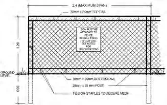
- Tree Protection Barrier: erect protective barrier fencing at CRZ perimeter where possible; minimum 1200mm height; solid frame; install prior to any construction; post signs.
- Arborist Supervision: all excavation within CRZs to be supervised by project arborist; severed roots to be pruned to sound tissue.
- Methods to Avoid Soil Compaction: use hog fuel / wood chips (20 cm), geotextile + crushed rock (15 cm), two layers of 19mm plywood, or steel plates.
- Paved Surfaces Above Tree Roots: consider floating permeable paving or raising paved surface to avoid root loss; use permeable materials where possible.
- Mulching: 5-8 cm wood chip/bark mulch; no mulch touching trunk.
- Landscaping & Irrigation: irrigation installation must account for CRZs; consult project arborist.
- Arborist Role: locate barrier fencing; review report with site supervisor; supervise excavation within CRZs; advise on pruning and machine clearances.

Retention / Removal Summary (from arborist)
- Remove: 1073, 1072, 1071, 1070, Nt1, Nt2
- Retain and protect: OS1–OS16 (with mitigation), M1, M2 (with protection fencing)

Photographs (Appendix B)
- Image 1: Cedar Hedge (Nt2) at Northern property line near Northeast corner of subject site.

Photo – Cedar Hedge (Nt2) near NE corner - Image 2: Plum tree 1071.
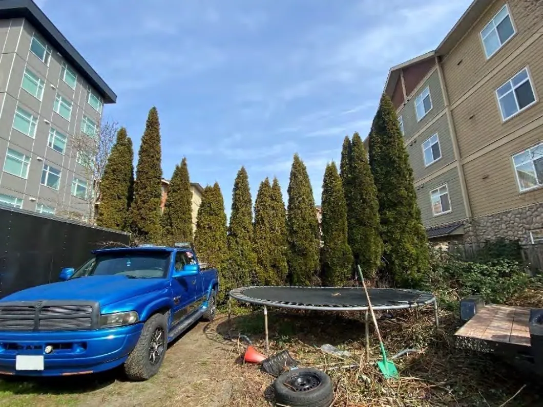
Photo – Plum tree 1071 - Image 3: Off site Garry oaks OS5 and OS6.
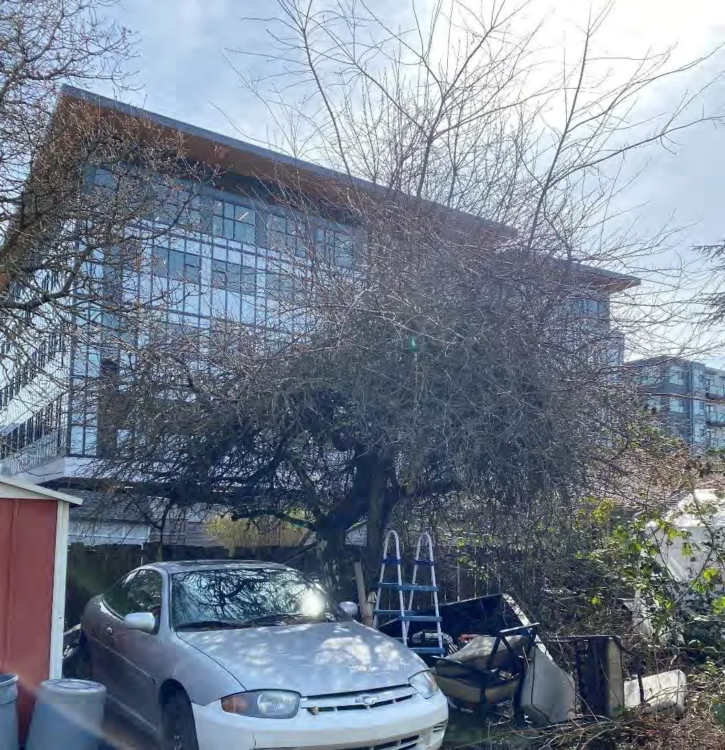
Photo – OS5 and OS6 Garry oaks - Image 4: Crown of Atlas cedar Nt1 located between existing houses.
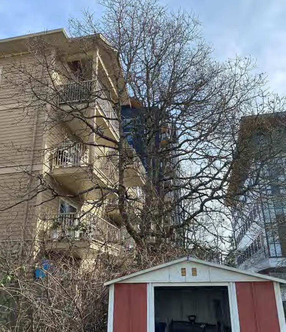
Photo – Crown of Atlas cedar Nt1 - Image 5: Plum 1072 located near Southwest corner of subject property.
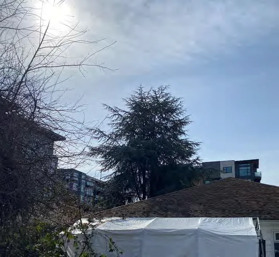
Photo – Plum 1072 - Image 6: On site Cherry tree #1073 (middle) and Offsite oaks OS5 and OS6 (background).
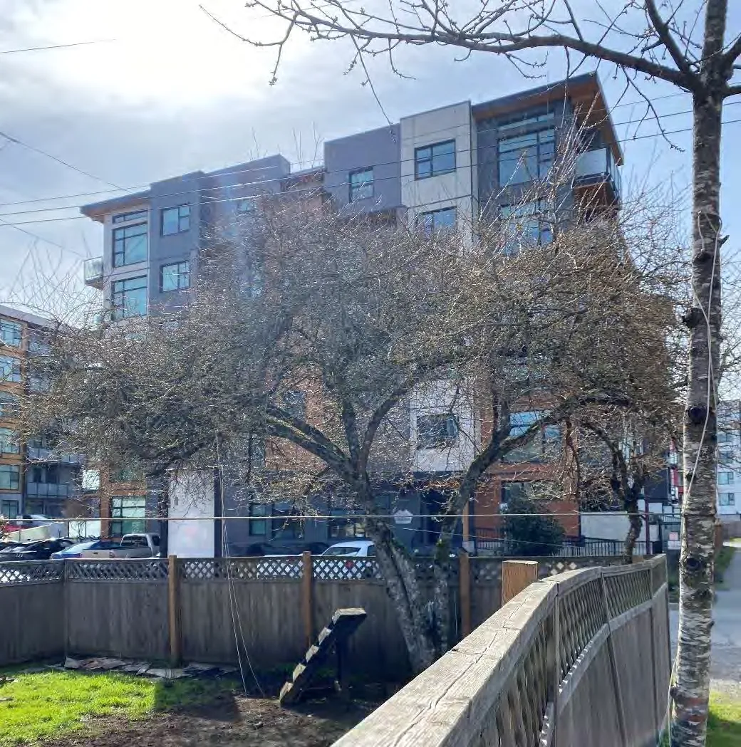
Photo – Cherry #1073 and OS5/OS6 - Image 7: Off-site Garry oak OS1 located beyond Northeast property corner.
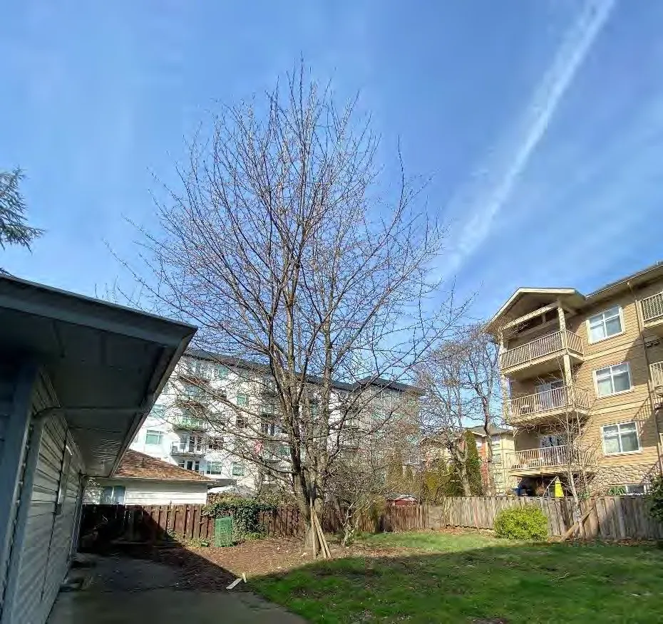
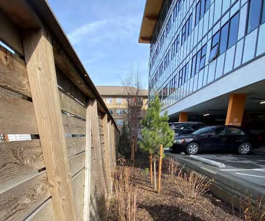
Photo – Off-site Garry oak OS1 - Image 8: Row of recently planted off-site trees (OS7-OS16) beyond Eastern property line.
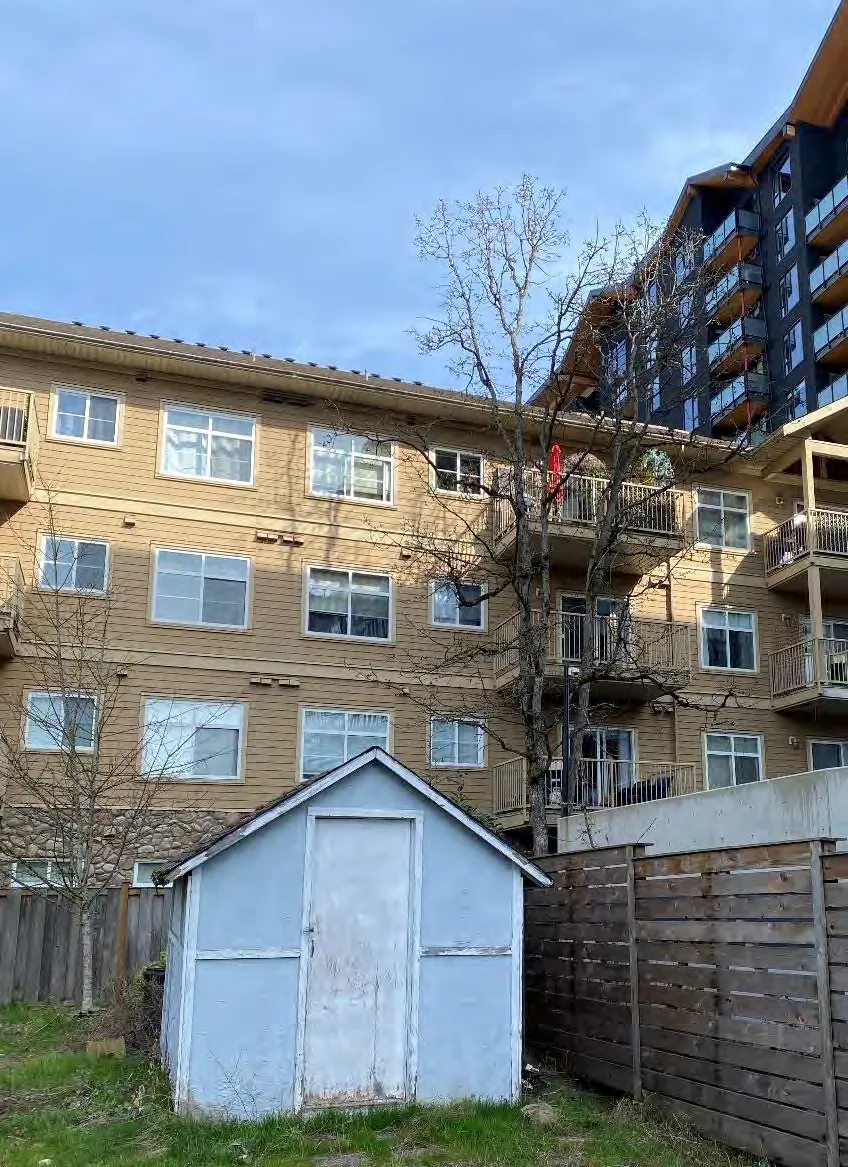
Photo – Row of recently planted off-site trees OS7–OS16
Appendices — Additional Drawings and Plans
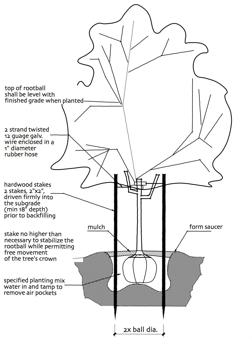
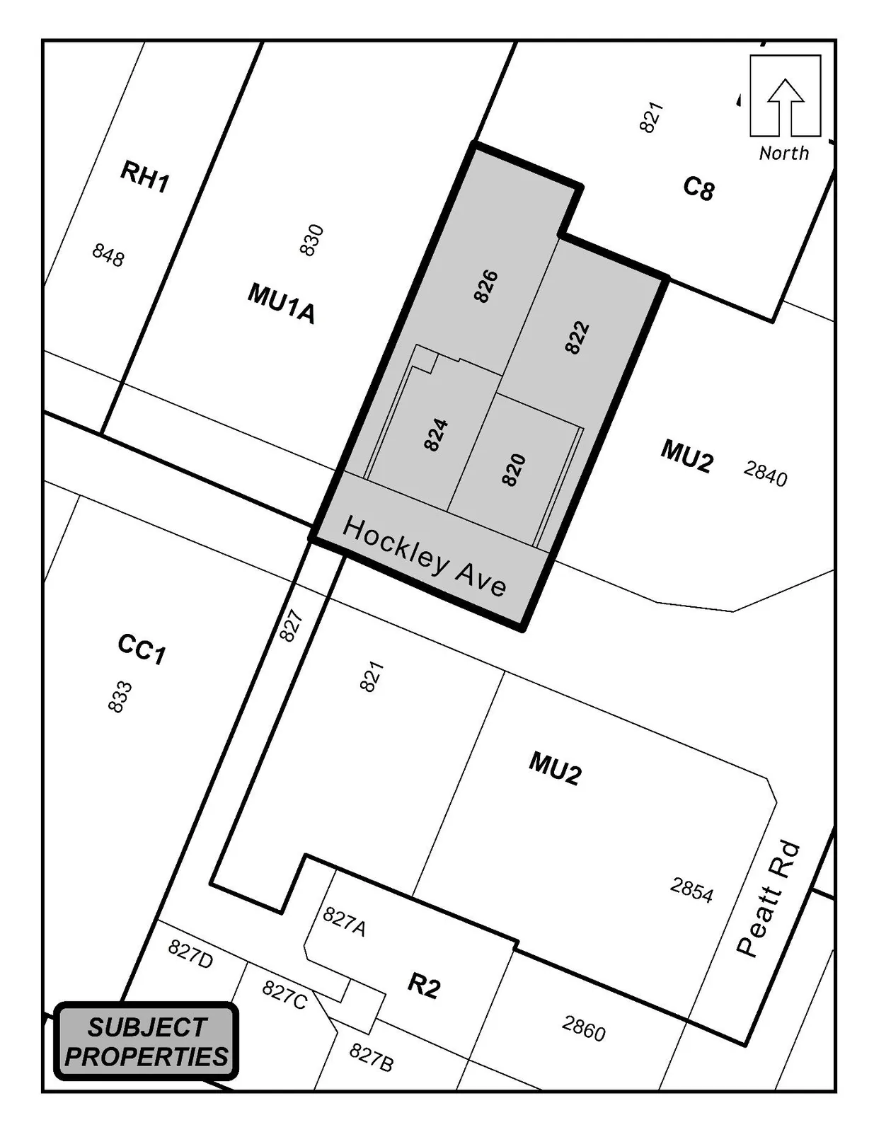
City of Langford — Bylaw No. 2142
CITY OF LANGFORD
BYLAW NO. 2142
A BYLAW TO AMEND BYLAW NO. 300, “LANGFORD ZONING BYLAW, 1999"
The Council of the City of Langford, in open meeting assembled, hereby enacts as follows:
A. Langford Zoning Bylaw No. 300, 1999 is amended as follows:
- By deleting from the One- and Two-Family Residential (R2) Zone and adding to the City Centre (CC1) Zone the properties legally described as:
a) Strata Lot B, Section 5, Esquimalt District, Strata Plan VIS3644, PID No. 023-028-751 (820 Hockley Ave);
b) Strata Lot A, Section 5, Esquimalt District, Strata Plan VIS3644, PID No. 023-028-742 (822 Hockley Ave);
c) Strata Lot 2, Section 5, Esquimalt District, Strata Plan VIS3260, PID No. 018-776-159 (824 Hockley Ave);
d) Strata Lot 1, Section 5, Esquimalt District, Strata Plan VIS3260, PID No. 018-776-141 (826 Hockley Ave)
as shown shaded on Schedule A attached to and forming part of this Bylaw.
- By adding the following to Table 1 of Schedule AD:
| Zone | Bylaw No. | Legal Description | Amenity Contributions | Eligible for Reduction in Section 2 of Schedule AD |
|---|---|---|---|---|
| CC1 | 2142 | Strata Lot B, Section 5, Esquimalt District, Strata Plan VIS3644, PID No. 023-028-751 (820 Hockley Ave); Strata Lot A, Section 5, Esquimalt District, Strata Plan VIS3644, PID No. 023-028-742 (822 Hockley Ave); Strata Lot 2, Section 5, Esquimalt District, Strata Plan VIS3260, PID No. 018-776-159 (824 Hockley Ave); Strata Lot 1, Section 5, Esquimalt District, Strata Plan VIS3260, PID No. 018-776-141 (826 Hockley Ave) | a) $2,850 per residential unit created towards the General Amenity Reserve Fund on the 1st through 4th storeys; and b) $1,425 per residential unit created towards the General Amenity Reserve Fund on the 5th and 6th storeys; and c) 1,425 per non-market residential unit created towards the General Amenity Reserve Fund; and d) $750 per unit created towards the Affordable Housing Reserve Fund on the 1st through 4th storeys; and e) $375 per unit created towards the Affordable Housing Reserve Fund on the the 5th and 6th storeys; f) $375 per non-market residential unit created towards the General Amenity Reserve Fund; | No |
B. This Bylaw may be cited for all purposes as “Langford Zoning Bylaw, Amendment No. 704, (820, 822, 824 and 826 Hockley Avenue, Bylaw No. 2142, 2023".
READ A FIRST TIME this day of , 2023.
PUBLIC HEARING held this day of , 2023.
READ A SECOND TIME this day of , 2023.
READ A THIRD TIME this day of , 2023.
APPROVED BY THE MINISTRY OF TRANSPORTATION AND INFRASTRUCTURE this day of , 2023.
ADOPTED this day of , 2023.
PRESIDING COUNCIL MEMBER
CORPORATE OFFICER