DocumentsStaff ReportMar 18, 2024Pages 20–36
Staff Report – Bylaw No. 2162: Application to Rezone 902 Walfred Road (Z23-0023)
Staff report recommending Council consider first, second and third readings of Bylaw No. 2162 to rezone 902 Walfred Road from RS1 to RT1 to permit approximately 29 townhouse units with 31% undisturbed open space and conditions.
Key facts
- Civic address: 902 Walfred Road (Lot 1, Section 78, Plan 22056, PID 003-297-411)
- Proposal: Rezoning from RS1 to RT1 to allow ~29 townhouse units across 9 blocks; 31% undisturbed open space
- Variance requested: rear lot line setback from 5.5m to 3.0m for portions of the site
- Amenity contributions (policy): $3,660 per unit (General Amenity) and $610 per unit (Affordable Housing) — totals $106,140 and $17,690 (29 units)
- Estimated Development Cost Charges (total to City ~ $216,927.25; total DCCs including CRD and other items ~$317,180.25)
Staff Report – Bylaw No. 2162: Application to Rezone 902 Walfred Road (Z23-0023)
Date
Monday, March 11, 2024
Department
Planning
Application No.
Z23-0023
Subject
Bylaw No. 2162 – Application to Rezone 902 Walfred Road from Residential Small Lot (RS1) to Residential Townhouse 1 (RT1) to allow the development of approximately 29 townhouse units.
PURPOSE
Rachael Sansom of Grayland Consulting Ltd. has applied on behalf of 1112264 B.C. Ltd to rezone 902 Walfred Road from Residential Small Lot (RS1) to Residential Townhouse 1 (RT1) to allow for the development of approximately 29 townhouse units across 9 blocks, with 31% undisturbed open space.
BACKGROUND
Previous Applications
DP20-0048 – In October 2020 the property owners applied for and obtained a Development Permit to allow for ditch realignment and remediation work within the Habitat and Biodiversity and Extreme Fire Hazard Development Permit Areas.
Z21-0042 – In 2022, the property was rezoned from RR5 (Rural Residential 5) to RS1 (Residential Small Lot 1) through Bylaw No. 2030. At the time, the applicant proposed a 13-lot subdivision, with retention of the established single-family dwelling. 31% of open space was proposed to be retained as strata common property for the bare land strata.
DP22-0014 – In April of 2022, the City issued a Development Permit for the subject property for the 13-lot subdivision. The permit allowed for land alteration and clearing within the Extreme Fire Hazard and Potential Wildlife Habitat and Biodiversity Development Permit Areas. Land clearing and grading has been completed under this permit.
Despite obtaining a Development Permit and beginning the land preparation process the applicant has chosen not to proceed with the subdivision and instead wishes to pursue this application for 29 townhouse units. The applicant has noted that this proposal evolved to meet the increased demand for more attainable housing.
Table 1: Site Data
| Item | Information |
|---|---|
| Applicant | Rachael Sansom, Grayland Consulting Ltd. |
| Owner | 1112264 B.C. Ltd |
| Civic Address | 902 Walfred Road |
| Legal Description | LOT 1, SECTION 78, ESQUIMALT DISTRICT, PLAN 22056, PID 003-297-411 |
| Size of Property | 9234m² (2.28 ac) |
| DP Areas | Potential Habitat & Biodiversity, Extreme Fire Hazard |
| Zoning | Existing: RS1 Proposed: RT1 |
| OCP Designation | Existing: Hillside or Shoreline Proposed: Hillside or Shoreline |
SITE AND SURROUNDING AREA
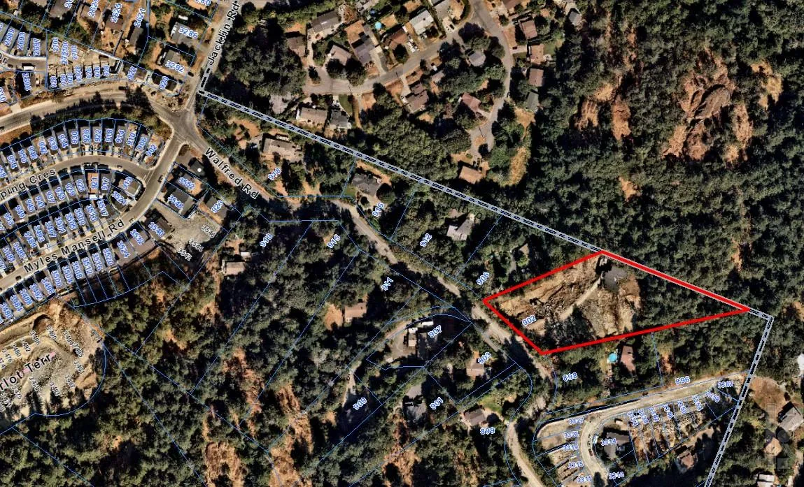
The subject property is located on the north side of Walfred Road, on the north side of Triangle Mountain, directly adjacent to the City of Colwood municipal border. The site has been cleared and graded where required in preparation for development under the previously issued Environmental/Hazardous Development Permit, with vegetation remaining intact in the rear (eastern) portion of the lot, along the northern property line, and along the frontage as demonstrated by Figure 1 below. The applicant has indicated that no further clearing is required to accommodate the new proposal for 29 townhouses. The site features an elevation rise in two directions: one ascending to the south along the front of the site and another ascending towards the rear portion of the property, peaking in the very east corner of the lot. The site currently contains a large single-family dwelling, which is not proposed to be retained as part of the development.
The surrounding properties are primarily large estate lots zoned for rural residential use, with similar topography and environmental conditions. It is noted that to the west of the subject site, near Jacklin Road, there are various new small lot subdivisions that have been completed over the past several years. To the south, there is a 15-lot single-family subdivision underway. During the referral process City of Colwood has noted that there is an active Development Permit that will enable the construction of 43 townhouses approximately 250 meters northeast of the site and have indicated that the area is expected to develop further in the future. Ernhill Park, Sedgwick Park, and Ed Fisher Memorial Park are all within a fifteen-minute walk from the subject site.
School District No 62 has been made aware of this application such that they can consider the proposed increase in density in this area as part of their long-range facility planning. The proposed development is also located within the 800m of a Controlled Access Highway under the jurisdiction of the Ministry of Transportation and Infrastructure (MoTI) and is therefore subject to their review. During the referral stage of the application, MoTI has not identified any concerns with the proposal from their perspective.

Table 2: Surrounding Land Uses
| Zoning | Use |
|---|---|
| North | City of Colwood |
| City of Colwood | |
| East | City of Colwood |
| City of Colwood, single-family homes | |
| South | RR1 (Rural Residential 1), R2 (One- and Two-Family Residential) |
| Single-family homes | |
| West | RR5 (Rural Residential 5) |
| Single-family homes |
COUNCIL POLICY
Official Community Plan
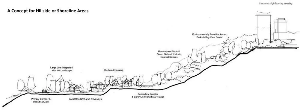
The Official Community Plan (OCP) Bylaw No. 1200 designated the subject properties as “Hillside or Shoreline” which is defined by the following text:
Predominantly existing low intensity settled areas throughout community with a high percentage of open space and undeveloped areas located on a hillside or near the shoreline.
- Predominantly residential precinct that supports a range of clustered (See Glossary & next page) low, medium and high-density housing choices including secondary suites. Higher building forms, such as point towers, will be permitted on hillsides to maximize open space provided some conditions are satisfied (see policies for this area)
- Schools, community facilities and other institutional uses are permitted throughout the area.
- Home-based businesses, live-work housing is encouraged; Home-based accommodations (e.g. Bed & Breakfasts) are permitted.
- Parks, open spaces and green corridors (creeks, wildlife corridors, trails, etc.) are integrated throughout the area. Large playfields are discouraged due to grading requirements. Site and topographic responsive pocket parks, enhanced viewpoints, graded hiking and walking trails, children’s play areas, including ‘tot lots’ and outdoor exercise areas are strongly encouraged on hillside areas.
- This area allows for Neighbourhood Centres to emerge in the form of high and medium density clustered mixed-use nodes.
- Transit stops are located where appropriate.
Amending the zoning of the subject property from RS1 to RT1 will align with the OCP designation, as it encourages the diversification of housing options in a traditional single-family neighbourhood through the addition of medium density housing such as townhouses, while preserving a significant amount of open space, totalling at 31% of the lot. As the majority of the non-disturbance open space is provided in the eastern portion of the lot and is unfragmented, the proposal aligns with the objective of providing connectivity of open space so as to create a network that supports trails and wildlife movement. The design also takes into account the natural features of the land. Terrain adaptive design allows for the preservation of the undulating topography and maintains views and key landscape features, in accordance with the OCP objective.
South Langford Neighbourhood Plan (SLNP)
The South Langford Neighbourhood Plan designated 902 Walfred Road as Large Lot Residential. This designation is described as the following:
Large Lot Residential – applies to areas where existing development patterns allow for limited infill development opportunities. A maximum density of 1 lot per 1000m² (4 units per acre) is applicable.
Based on the lot size and the density noted above, the property would be suitable for a maximum of 9 units according to the density prescribed by the SLNP. The proposal is for 29 units, which exceeds the density prescribed by the SLNP.
It is important to note that the previous proposal was for 13 single family homes, which also exceeds the prescribed density. The current proposal does not require further land clearing and offers a more affordable housing option as well as increased open space amenities for the residents.
Council may also wish to note that the South Langford Neighbourhood Plan precedes the City’s Official Community Plan. At the time, the SLNP was retained with the design guidelines as a reference. Council may wish to note that zoning is required to comply with the OCP but is not required to comply with the design guidelines, including the SLNP.
Development Permit Areas
The subject property is located within the Potential Habitat and Biodiversity and Extreme Interface Fire Hazard Development Permit Areas. An Environmental Impact Assessment prepared by a professional registered biologist as well as a Wildfire Hazard Assessment prepared by a professional forester were submitted as part of the application package for the Development Permit for the original proposal. A biologist was also engaged to monitor land clearing activities on site, as required as a condition of the issued Development Permit. As no further land clearing is required to accommodate this proposal for 29 townhouse units, no revised report is necessary. The proposal will also be required to comply with mitigation strategies outlined in the Wildfire Hazard Assessment.
As the proposal no longer includes a bare land strata subdivision, requirements contained within the Development Permit that were required to be completed prior to subdivision shall be completed prior to building permit issuance. A Section 219 Covenant shall be registered, prior to building permit issuance, agreeing to the following: i. No Outdoor burning shall occur on the subject property; ii. A fuel reduced buffer shall be maintained at all times from the perimeter of every building to a distance equal to 10m (32ft) from the perimeter of every building, or to the property boundary, whichever is less, and that this area shall be landscaped and maintained with the intent of eliminating the accumulation of combustible debris; iii. If the fuel reduced buffers are not maintained, that the owner shall be required to pay a rent charge to the City of Langford of $1,000 per year; and iv. All areas not within the fuel reduced buffer or the building footprint shall be maintained as a non-disturbance area where the removal of any vegetation is prohibited, without prior written consent of the City of Langford;
Additionally, permanent fencing (split rail or other approved by the Director of Planning) to demarcate the open space shall be installed, or bonded for, to the satisfaction of the Director of Planning, prior to building permit issuance. This requirement should also be secured in a Section 219 Covenant.
As the applicant is proposing townhouses, a Form and Character Development Permit will be required prior to obtaining building permits for the site. A Form and Character Development Permit will ensure that the proposal complies with the standards prescribed by the Zoning Bylaw No. 300 as well as addresses the final layout and character of the townhouses pursuant to the Multi-Family Design Guidelines.
Low Carbon Concrete
In accordance with Council’s Low Carbon Concrete Policy POL-0167-PLAN, Council may wish to require the applicant to utilize ready-mix concrete that meets or exceeds the weighted average Global Warming Potential targets based on Concrete BC Baseline (average) mix data for the construction of the proposed development.
COMMENTARY
Development Proposal
The applicant is proposing to rezone the subject property from RS1 (Residential Small Lot 1) to RT1 (Residential Townhouse 1) to allow for a townhouse development with approximately 29 units contained within 9 blocks, as illustrated in Figure 2 below and in a detailed version of the site plan attached to this report for reference. The applicant is requesting one setback variance from the rear lot line, which will be discussed later in the report. The existing large single-family dwelling will be demolished to accommodate this proposal.
With the design that steps into the hillside, the height of the proposed townhouses ranges from 2 storeys to 3 storeys. This tiered design provides visual interest and allows for the use of native rock, rather than vertical concrete blocks, reducing the amount of required blasting. Each townhouse is to provide a minimum 10m² of private open space as either ground floor patio, a deck, or a combination of both, depending on the topography and the location of a townhouse block. Each townhouse unit is to face the proposed new strata road, with either a single-wide garage and driveway, or double-wide double car garage on the ground floor and living space large enough to accommodate two- and three-bedroom layouts. To remain consistent with the townhouse developments that have been recently rezoned, Council may wish to require that garages are to be used for parking of vehicles and not storage of items in a manner that would prevent utilization of the garage space for parking purposes. Council may wish to have the covenant registered in favour of the strata so that they are responsible for enforcing the covenant instead of the City.
Each garage will have EV charger plugs and all townhouse units will be roughed in for future solar panel installation. Five of the homes will have elevator shafts roughed in for future mobility needs of the owner. The applicant has also proposed heat pumps for heating and cooling. For consistency, Council may wish to secure this as a requirement within a Section 219 Covenant, prior to the Bylaw Adoption, in line with previous recent rezoning applications.
The applicant is demonstrating a minimum of 2 parking spaces per unit on their site plan, with 19 of the townhouse units containing double wide double car garages, and 10 units containing single car garages and a single wide driveway. They have also demonstrated 5 shared visitor parking spaces, which meets the minimum requirement of the bylaw for townhouse developments over 21 units.
As per the original proposal, the applicant is providing a significant amount of undisturbed greenspace totaling 2,853m2 or 31% of the site area. The applicant is proposing to construct a trail to encourage residents to stay on a dedicated path and limit encroachment into the native ecosystem greenspace, while enjoying its benefits. The proposed trail does not require any vegetation removal in the proposed open space and is to be constructed around the existing trees. The proposed green space shall be registered as strata common property. Council may wish to require that the applicant register a non-disturbance covenant over these lands to ensure this greenspace is retained as proposed.
In addition to 31% non-disturbance green space, the proposal includes a 225m2 active outdoor common amenity space in the center of the site. As shown in Figure 3 below, the common amenity space features a natural playground area, picnic tables, a gazebo/sun shelter, seating, and raised garden boxes for the use of the strata residents. Landscaping conceptual plans provided as part of this proposal demonstrate a number of trees planted throughout the site, predominantly in front of townhouse Blocks 1, 2, and 9, as well as along the perimeter of the outdoor common amenity space. The conceptual plans are attached to this report for Council’s consideration. A landscape plan prepared by a Registered Landscape Architect in a good standing with the British Columbia Society of Landscaped Architects will be required at the Form and Character Development Permit stage, with exact number and species of proposed plantings confirmed. The applicant has indicated that they will give preference to drought resistant native species.
A common outbuilding, located east of Block 9, provides secure storage and maintenance space for bikes and e-bikes. The building features a sustainable green roof as well as solar panels which will help accommodate e-bike charging. The outbuilding also features a wash station that can be used for bikes, as well as a dog-wash station.
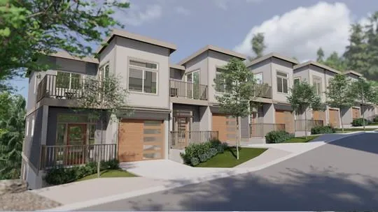
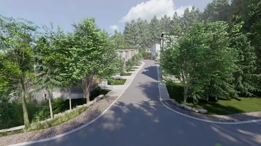
The applicant has also submitted a conceptual rendering of their proposal to better articulate the design and site layout, as can be seen in Figures 4 and 5 below. The applicant is proposing West Coast style townhouses with a neural colour palette for their development as evident from the conceptual renderings below. All buildings will also include fire-retardant roof materials and non-combustible siding materials as required by the Environmental/ Hazardous Development Permit. The final design, including finishing materials, will be secured thorough the Form and Character development permit.
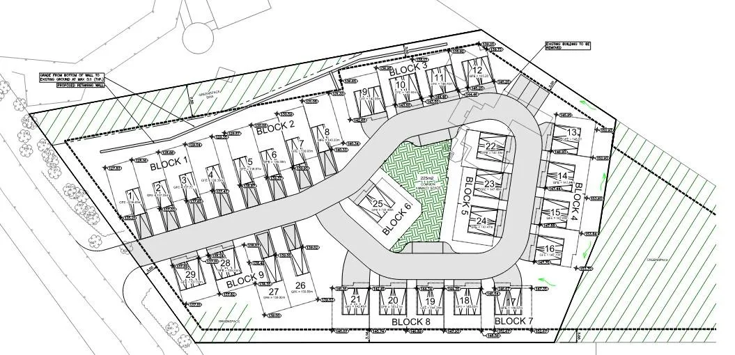
Figure 5 demonstrates street view of the proposed development, as will be seen from Walfred Road. The vegetation within the road allowance on Walfred Road is to be retained and protected during construction, in accordance with Subdivision and Servicing Bylaw No. 1000. This treed buffer will partially screen the development, therefore no walk-up units facing Walfred Road are proposed. This is consistent with the 15-lot subdivision to the south.
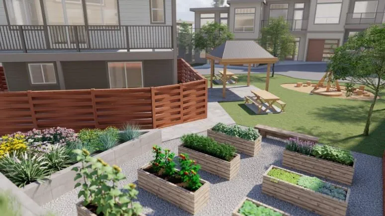
Table 3: Proposal Data
| Item | Permitted by RS1 (Current Zoning) | Permitted by RT1 (Proposed Zoning) | Proposed by Rezoning Application |
|---|---|---|---|
| Permitted Use | Single-family homes | Townhousing | Townhousing |
| Density (FAR and/or min. lot size) | 200m² | 1.2 FAR | 0.64 FAR |
| Height | 9m | 3 storeys | 3 storeys average |
| Site Coverage | 50% | 60% | 25% |
| Front Yard Setback | 3m except for a garage which must be 6m | 3m except for a garage which must be 5.5m | 3m |
| Interior Side Yard Setback | 1.5m | 1.2m | 3m |
| Exterior Side Yard Setback | 3.5m except for a garage which must be 5.5m | 3.5m except for a garage which must be 5.5m | N/A |
| Rear Yard Setback | 5.5m | 5.5m | *3m |
*Variance Requested
As noted in Table 3 above, the applicant is requesting a variance for the rear lot line setback from 5.5m to 3.0m for the corners of Blocks 3 and 4. The City of Colwood, which adjoins the subject property along this lot line, has indicated that they have no concerns with the proposed rear yard setback variance.
If Council has no objection to the requested variance noted above, they may wish to authorize the Director of Planning to include these variances in the Development Permit for Form and Character that will be issued for this site.
Multi-Modal Network
The subject site is located close to the intersection where the parcel enjoys access onto Jacklin Road, a major arterial road that connects traffic to Sooke Road, the downtown core, and to the Trans Canada Highway. The Director of Engineering has noted that no Traffic Impact Assessment is necessary for this proposal. As stated earlier in the report, the application has also been reviewed by the Ministry of Transportation and Infrastructure and they have expressed no objection.
Bike lanes are available at the intersection of Walfred and Jacklin, approximately 300m from the subject site. Ernhill Park, Sedgwick Park, and Ed Fisher Memorial Park are all within a fifteen-minute walk from the subject site. Happy Valley Elementary is the closest school and can be reached via 3-minute car drive, 5-minute bike ride, or a 20-minute walk. Various commercial businesses are available along Jacklin Road. As indicated above, a common bike storage shed will provided in the center of the site for secure storage, as well as washing, maintenance, and charging for e-bikes and scooters of residents.
The site is located approximately 100 meters from local bus service, providing access to route 59. This route connects Triangle Mountain to the Langford Exchange, which includes access to the Blink Rapid Bus Line 95, a key commuting service into downtown Victoria.
INFRASTRUCTURE
Frontage Improvements
Full frontage improvements will be required in accordance with Bylaw No. 1000 and to the satisfaction of the Director of Engineering prior to the issuance of a building permit. Of note, the Engineering Department has indicated that the proposal will be required to maintain the tree buffer along the frontage of the property as well as provide cash-in-lieu for a multi-use path.
Parks and Boulevard
The Parks Department has not required that any park land be provided with this development and requested that green space be registered as strata common property.
The original rezoning of the subject property required that vegetation within the road allowance of Walfred Road be retained and protected during the construction process. The applicant has maintained this tree buffer accordingly, including during the site clearing that occurred under Development Permit DP22-0014. This new proposal accounts for the protection of green buffer within the road allowance. This requirement is to be secured by way of a Section 219 Covenant.
Sewers
Sewer has been extended along Walfred Road past the subject property to serve a single-family subdivision to the south and is available to be extended into the site to serve the proposed development. Any improvements, extensions, or modifications needed to the sewer main within the municipal right-of-way will be completed by West Shore Environmental Services at the applicant’s expense.
Stormwater Management
The applicant will be required to provide a storm water management plan to the satisfaction of the Director of Engineering prior to the issuance of a building permit. As part of their application, the applicant has submitted a storm water management technical memo outlining how they plan to adequately manage storm water on-site. This memo has been reviewed and approved by the Director of Engineering.
Construction Impact Mitigation
Council may wish to require a Construction Parking and Traffic Management Plan as condition of rezoning and require that it be provided to the satisfaction of the Director of Engineering prior to issuance of a building permit, given that majority of land preparation works have already been completed. This requirement should be secured within a covenant, prior to Bylaw Adoption.
Neighbourhood Consultation
The applicant has indicated that a community consultation meet-and-greet was held in August 2023, where the neighbourhood residents had a chance to see the new set of plans, ask questions, and offer their thoughts on the new proposal. The applicant has noted that they are still in direct contact with the neighbouring property owners in case there are any questions or concerns.
FINANCIAL IMPLICATIONS
As noted in the Previous Applications section of this report, this site was previously rezoned in 2022 through Bylaw No. 2030. This bylaw included amenity contributions that form part of the City’s Zoning Bylaw and will still apply to this proposal, where applicable, unless Council chooses to remove it through this rezoning. The contributions secured through the bylaw are as follows:
- $3,690 per lot less than 550m2 towards the General Amenity Reserve Fund;
- $6,000 per lot 550m2 or greater towards the General Amenity Reserve Fund;
- $660 per lot less than 550m2 towards the Affordable Housing Reserve Fund;
- $1,000 per lot 550m2 or greater towards the Affordable Housing Reserve Fund
With the new proposal, items 1 through 4 would no longer be applicable as they pertain to single-family lots subdivided pursuant to the Land Title Act.
Given this, Council may wish to remove the Bylaw No. 2030 amenity contributions from the Zoning Bylaw and replace it with contribution shown below in Table 4 which aligns with the City’s current amenity policy for townhouse units. The amenity contributions would be secured through Bylaw No. 2162, as attached.
Rezoning the subject properties to permit higher density of development will increase the assessed value of lands and eventually will increase municipal revenue due to the number of units created. As the developer is responsible to complete all frontage improvements, the direct capital costs to the City associated with this development will be negligible. A summary of Amenity Contributions and Development Cost Charges that the developer will be expected to pay, is outlined in Tables 4 and 5 below.
Council’s Amenity Contribution Policy
The amenity contributions that apply as per Council’s current Affordable Housing and Amenity Contribution Policy are summarized in Table 4 below, based the current floor plans and total density of 29 residential units.
Table 4 – Amenity Contributions per Council Policy
| Amenity Item | Per unit contribution | Total (based on 29 units) |
|---|---|---|
| General Amenity Reserve Fund | $3,660 | $106,140 |
| Affordable Housing Reserve Fund | $610 | $17,690 |
| TOTAL POLICY CONTRIBUTIONS | $4,270 | $123,830 |
Table 5 - Development Cost Charges
| Development Cost Charge | Per Unit Contribution | Total |
|---|---|---|
| Roads | $3,865 | $112,085 |
| Storm Drainage | $1,166 | $33,814 |
| Park Improvement | $1,948 | $56,492 |
| Park Acquisition | $130 | $3,770 |
| ISIF | $371.25 | $10,766.25 |
| Subtotal (DCC’s to Langford) | $7,480 | $216,927.25 |
| CRD Water | $2,557 | $74,153 |
| School Site Acquisition | $900 | $26,100 |
| TOTAL DCC’s (estimated) | $10,937.25 | $317,180.25 |
LEGAL IMPLICATIONS
Should Council choose to proceed with this proposal, Bylaw No. 2162 will be scheduled for consideration of first, second and third readings. As per recent changes to the Local Government Act, a Public Hearing is not permitted.
The original rezoning application from 2022 required a covenant to be registered that outlined various development requirements some of which are not relevant to the new proposal. Council may wish to discharge the existing development covenant that was secured through Bylaw No. 2030, as all applicable requirements will be covered under the new covenant required or are already required through various City bylaws. All Council’s conditions of approval that pertain to the current proposal would be registered in a Section 219 Covenant in priority of all other charges on title prior to consideration of Bylaw Adoption.
The amenity contributions specified in Table 4 above are incorporated into Bylaw No. 2162 and will be payable at the time of building permit along with the current Development Cost Charges specified in the various DCC Bylaws.
OPTIONS
Option 1
THAT the Sustainable Development Advisory Committee recommend that Council:
- Proceed with consideration of First, Second, and Third Reading of Bylaw No. 2162 to amend the zoning designation of the properties located at 902 Walfred Road from RS1 to RT1 subject to the following terms and conditions:
a. That the applicant provides, as a bonus for increased density, the following contributions per dwelling unit, prior to the issuance of a building permit:
i. $610 towards the Affordable Housing Reserve Fund; and
ii. $3,660 towards the General Amenity Reserve Fund;
b. That the applicant provides, prior to Bylaw Adoption, a release of the covenant that was previously registered under CA976093, and registers a new Section 219 covenant in priority of all other charges on title, that agrees to the following: i. That the following will be provided and implemented to Bylaw No. 1000 standards to the satisfaction of the Director of Engineering prior to the issuance of a building permit:
- Full frontage improvements;
- A storm water management plan; and
ii. That a Construction Parking and Traffic Management Plan and Mitigation Plan in accordance with Bylaw 1000 Section 2.5 be provided to the satisfaction of the Director of Engineering prior to any alteration of land.
iii. That vegetation within the road allowance on Walfred Road should be retained. If any vegetation is removed, the applicant is required to replant the area and provide a temporary irrigation system from a private irrigation system to the satisfaction of the Director of Parks, Recreation and Facilities.
iv. That electric heat pumps are installed in the townhouse units.
v. That a separate non-disturbance covenant be registered over 31% of the land to be protected as open space on strata common property, prior to issuance of a building permit.
vi. That a separate covenant be registered prior to the registration of a strata plan for the proposed development agreeing that the garages are to be used for the parking of vehicles and not the storage of items preventing the parking of vehicles therein, in favour of the strata.
vii. That a separate covenant be registered, prior to issuance of a building permit, agreeing to the following:
- No outdoor burning shall occur on the subject property;
- A fuel reduced buffer shall be maintained at all times from the perimeter of every building to a distance equal to 10m (32 ft) from the perimeter of every building, or to the property boundary, whichever is less, and that this area shall be landscaped and maintained with the intent of eliminating the accumulation of combustible debris;
- If the fuel reduced buffers are not maintained, that the owner shall be required to pay a rent charge to the City of Langford of $1000 per year; and
- All areas not within the fuel reduced buffer or the building footprint shall be maintained as a non-disturbance area where the removal of any vegetation is prohibited, without prior written consent of the City of Langford.
viii. That a permanent fencing (e.g. split rail or other approved by the Director of Planning) to demarcate the non-disturbance open space shall be installed, or bonded for, to the satisfaction of the Director of Planning prior to building permit issuance.
ix. That all concrete used on-site will utilize ready-mix concrete that meets or exceeds the weighted average Global Warming Potential targets based on Concrete BC Baseline (average) mix data, and that prior to the issuance of a Building Permit the applicant shall provide a Type III Environmental Product Declaration that is 3rd party verified specifying the total Global Warming Potential value and confirming that the proposed development meets the requirements of Low Carbon Concrete Policy POL-0167-PLAN;
AND
- Amend the text of Schedule AD of the Zoning Bylaw No. 300 to remove the amenity contributions related to Bylaw No. 2030;
AND
- Authorize the Director of Planning and Subdivision to issue the following variance in the Form and Character Development Permit:
i. Section 6.28.07(1)(d) to reduce the rear lot line setback from 5.5m (18 ft) to 3.0m (10 ft).
OR Option 2
THAT the Sustainable Development Advisory Committee recommend that Council take no action with respect to this application to rezone 902 Walfred Road under Bylaw No. 2162 until such time as the following items are addressed and reviewed by the Sustainable Development Advisory Committee:
a. ________________;
b. ________________;
c. ________________;
SUBMITTED BY
Anastasiya Mysak, Planner I
Concurrence
- Leah Stohmann, MCIP, RPP, Deputy Director of Planning and Subdivision
- Donna Petrie, Senior Manager of Communications & Economic Development
- Yari Nielsen, Director of Parks, Recreation and Facilities
- Matthew Baldwin, MCIP, RPP, Director of Planning and Subdivision
- Katelyn Balzer, P.Eng., Director of Engineering and Public Works
- Michael Dillabaugh, CPA, CA, Director of Finance
- Marie Watmough, Deputy Director of Corporate Services
- Braden Hutchins, Director of Corporate Services
- Darren Kiedyk, Chief Administrative Officer
Attachments
- Proposed Site Plan (902 Walfred)
- Proposed Landscape Plan (902 Walfred)
Related Documents
(4)Langford Zoning Bylaw, Amendment No. 714, (902 Walfred Road)
Bylaw No. 2162 · Referenced in 4 sections
Langford Zoning Bylaw, Amendment No. 655, (902 Walfred Road)
Bylaw No. 2030 · Referenced in 4 sections
Zoning Bylaw
Bylaw No. 300 · Referenced in 2 sections
Subdivision and Development Servicing Bylaw
Bylaw No. 1000 · Referenced in 3 sections