DocumentsAppendixMar 18, 2024Pages 39–45
Supporting Images / Scanned Attachments (902 Walfred) - pages
Image-dominant scanned pages (maps/diagrams/attachments) related to the 902 Walfred rezoning application.
Key facts
- Pages are image-dominant / scanned (low OCR reliability)
- Supplementary visuals for rezoning application (maps, diagrams, site sections)
Page 1
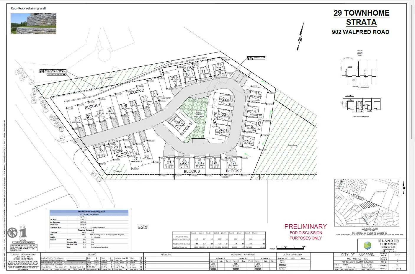
Project title and address
- 29 TOWNHOME STRATA
- 902 WALFRED ROAD
Key labels on plan
- Redi-Rock retaining wall [Image shown top-left of page]
- BLOCK 1
- BLOCK 2
- BLOCK 3
- BLOCK 4
- BLOCK 5
- BLOCK 6
- BLOCK 7
- BLOCK 8
- BLOCK 9
- Units numbered 1 through 29 (units distributed among blocks)
- COMMON OUTBUILDING (located in central courtyard)
- GREENSACE (note: appears as "GREENSPACE" in multiple locations)
- LOCATION PLAN (small inset map)
- ISLANDER ENGINEERING (consultant logo and block)
- CITY OF LANGFORD (project jurisdiction identifier)
Notes and small tables (bottom-left inset)
Site features called out on drawing
- Visitor parking and resident parking areas
- Entrances and drive aisle
- Pedestrian paths and stair accesses
- Retaining walls and slope limits
- Tree/vegetation protection areas and proposed tree planting locations
Design text (scattered on plan)
- CONSTRUCT UNDERGROUND (near left margin)
- LEGEND (near bottom margin — contains symbols for plantings, surfaces, walls, etc.)
- DESIGNER / APPROVED / REVISIONS block (title block area)
Page 2
Section views and labels
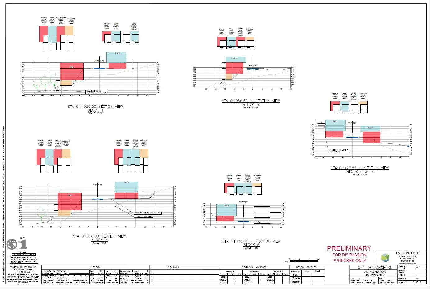
- STA 0+030.00 SECTION VIEW — BLOCK 1 (scale 1:250)
- STA 0+050.00 SECTION VIEW — BLOCK 2 (scale 1:250)
- STA 0+086.69 — SECTION VIEW — BLOCK 3 (scale 1:250)
- STA 0+123.58 — SECTION VIEW — BLOCK 4 & 5 (scale 1:250)
- STA 0+155.00 — SECTION VIEW — BLOCK 8 (scale 1:250)
Typical notations on sections
- Existing grade and proposed finished grade lines
- Building unit massing colored blocks (legend indicating unit footprints by colour)
- Notes indicating finished floor elevations and relative heights
- Trees / vegetation shown schematically adjacent to sections
Small plan view diagrams
- Typical unit elevation diagrams (plan view showing unit relationships and rooflines)
Legend and title block (bottom edge)
- LEGEND (symbols for existing trees, proposed plantings, retaining walls, etc.)
- REVISIONS / APPROVED / DESIGN APPROVED (title block area)
Page 3
Main headings on page
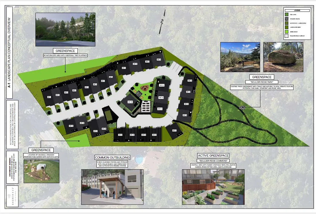
- LANDSCAPE PLAN CONCEPTUAL OVERVIEW
Key annotated areas on the plan
- GREENSACE (upper northwest edge) — labelled "RE-NATURALIZED AREA WITH ADDITIONAL TREE PLANTINGS"
- GREENSACE — labelled "BOULDER RIDGE PARK" with description "EXISTING TRAILS RETAINED WITH TRAILS AND NATURAL OPEN SPACE. PROPOSED FEATURE: POTENTIAL SOD, VIEWPOINT, PICNIC AREA" [Note: wording approximated from visible text]
- GREENSACE (southwest) — "LOCATION OF SECONDARY DRAINAGE PROPOSED RAIN GARDEN WITH NATIVE PLANTS"
- COMMON OUTBUILDING — "BIKE CHARGING STATION AND STORAGE WITH SOLAR PANELS AND GREEN ROOF AND OUTDOOR DOG-RINSING STATION" (callout)
- ACTIVE GREENSPACE — "BOULDER RIDGE COMMONS" — "CENTRAL AREA WITH RAISED VEGETABLE BEDS, POLLINATOR GARDEN, PICNIC/SEATING AREA, AND PLAYGROUND" (callout)
Inset images (photographic inspirations)
Example trees and slope planting 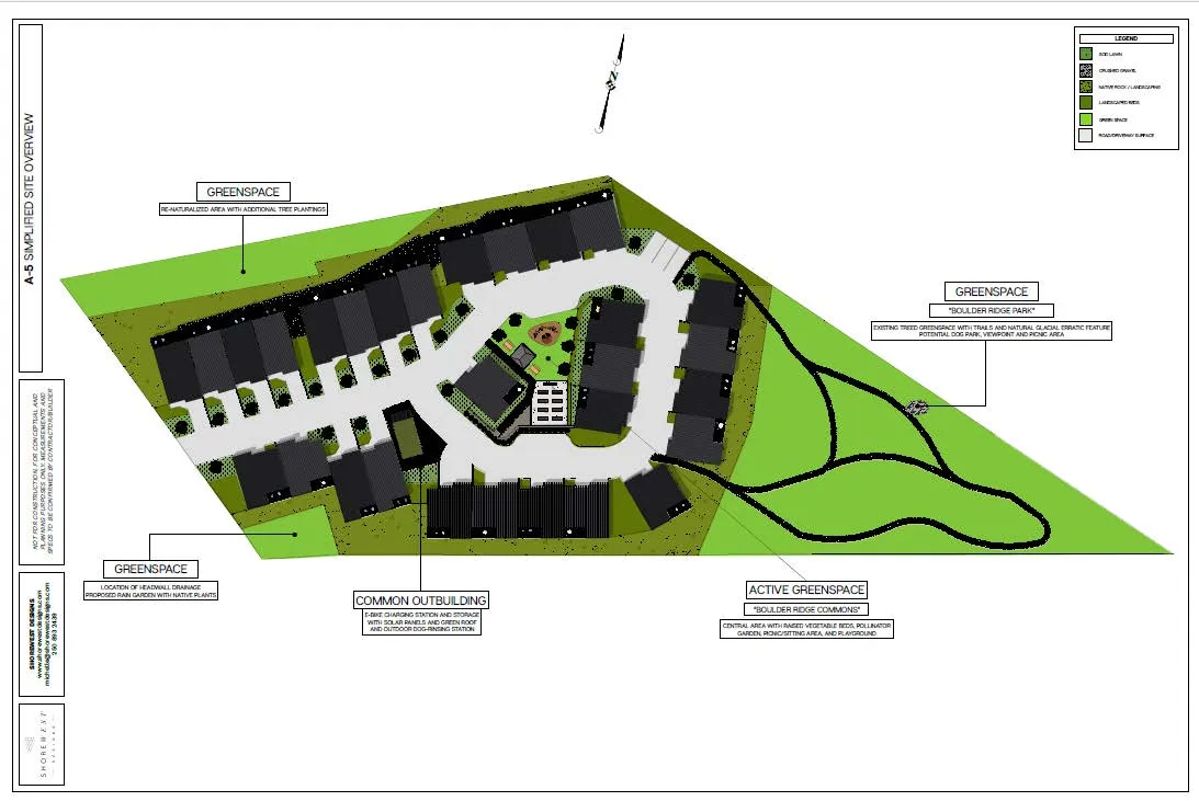
Natural trail with bench and large boulder
Labels for units visible around courtyard
- UNIT numbers around central area (labels such as UNIT 1, UNIT 2, etc. visible on plan)
Page 4
Main headings and callouts
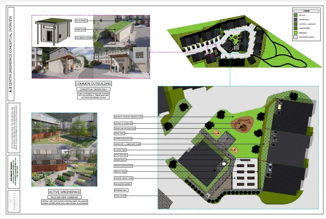
- COMMON OUTBUILDING — "CONCEPTUAL DESIGN ONLY" (top-left)
- Callouts around common outbuilding images:
- SOLAR PANELS
- GREEN ROOF
- DOG WASHING STATION
- BIKE PARKING/STATION
- Callouts around common outbuilding images:
- ACTIVE GREENSPACE — "BOULDER RIDGE COMMONS" — central plan shows:
- (callouts pointing to plan features)
- DRAINAGE / INFILTRATION MICRO-LOCATIONS
- NATIVE PLAY AREA
- SAND/CHIP PLAY SURFACE
- PICNIC TABLE
- GAZEBO/OPEN SHELTER
- GRASS SOD + LANDSCAPED AREA
- PLANTED TREES
- RAISED GARDEN BOXES
- PRIVACY FENCE
- CRUSHED GRAVEL BASE
- POLLINATOR GARDEN
- RETAINING WALL
- STAIR ACCESS
- (callouts pointing to plan features)
Photographic inspirations and conceptual renderings
-
-
Notes (left margin)
- Text block referencing plan development and conceptual nature of drawings (text too small for full verbatim transcription)
Page 5
Main headings
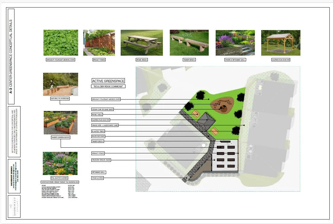
- A3 CENTER GREENSPACE CONCEPTUAL DETAILS
Images / thumbnails with labels (across top)
- DROUGHT-TOLERANT MICRO-CLIMBER (likely typo in thumbnail label; presented as image caption)
- PRIVACY FENCE
- PICNIC TABLE
- TIMBER BENCH
- STEPS & RETAINING WALL
- GAZEBO/OPEN SHELTER
Active greenspace annotated plan (right side)
- ACTIVE GREENSPACE — "BOULDER RIDGE COMMONS" (callouts)
- NATURAL PLAYGROUND
- DROUGHT-TOLERANT MICRO-CLIMBERS
- CEDAR CHIPS OR SAND BASE
- PICNIC TABLE
- GAZEBO / OPEN SHELTER
- GRASS SOD + LANDSCAPED AREA
- PLANTED TREES
- RAISED GARDEN BOXES
- PRIVACY FENCE
- CRUSHED GRAVEL BASE
- POLLINATOR GARDEN
- RETAINING WALL
- STAIR ACCESS
Planting palette and notes (lower-left)
- POLLINATOR GARDEN (image with plant list beneath — list text too small for verbatim transcription)
- RAISED GARDEN BOXES (image)
- NATURAL PLAYGROUND (image)
- NOTE: Multiple callouts pointing to planting beds and hardscape elements; specific plant species list not legible at this resolution
Page 6
Main heading
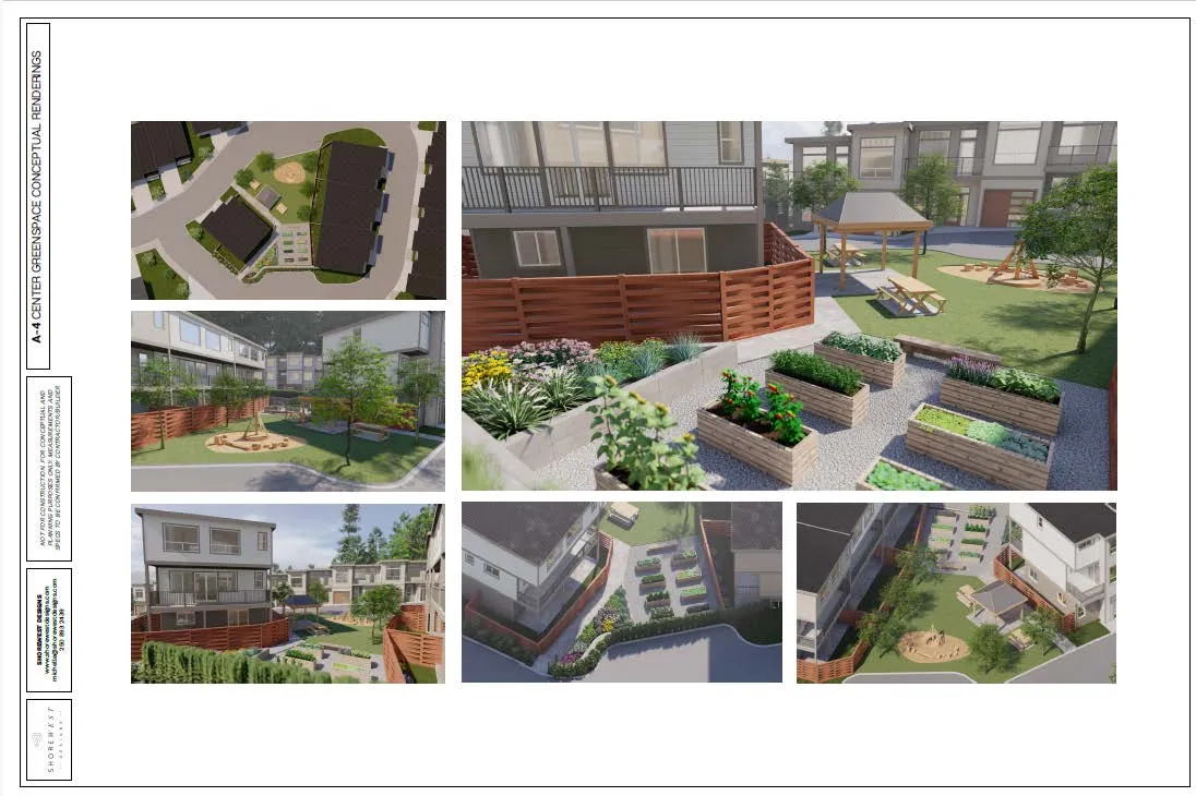
- A4 CENTER GREENSPACE CONCEPTUAL RENDERINGS
Render images and captions (six perspective images)
- Top-left: aerial view of central greenspace and common outbuilding [Image]
- Top-right: perspective view of raised garden beds and gazebo adjacent to residential units [Image]
- Middle-left: ground-level view of central playground and seating area with fencing [Image]
- Middle-right: close-up of raised garden beds with planted vegetables and shrubs [Image]
- Bottom-left: perspective of residential streetscape and courtyard access [Image]
- Bottom-right: aerial view of garden bed rows and courtyard circulation [Image]
No additional textual callouts legible beyond captions/labels for the renderings.
Page 7
Main heading
- A-5 SIMPLIFIED SITE OVERVIEW
Plan callouts
- GREENSACE (northwest) — "RE-NATURALIZED AREA WITH ADDITIONAL TREE PLANTINGS"
- GREENSACE (east) — "BOULDER RIDGE PARK" — "EXISTING TRAILS RETAINED WITH TRAILS AND NATURAL OPEN SPACE. ORGANIC FEATURE: POTENTIAL SOD, VIEWPOINT, PICNIC AREA" (approximate wording as visible)
- COMMON OUTBUILDING — "BIKE CHARGING STATION AND STORAGE WITH SOLAR PANELS AND GREEN ROOF AND OUTDOOR DOG RINSING STATION" (callout)
- ACTIVE GREENSPACE — "BOULDER RIDGE COMMONS" — "CENTRAL AREA WITH RAISED VEGETABLE BEDS, POLLINATOR GARDEN, PICKNICK/SEATING AREA, AND PLAYGROUND" (approximate wording as visible)
Legend (top-right)
- LEGEND with colour keys indicating:
- TREE LINES
- EXISTING TREES
- CONIFEROUS / DECIDUOUS PLANTINGS
- LOW PLANTING / GROUNDCOVER
- PROPOSED PATHS / TRAILS
- PROPOSED SOD
Plan features
- Central courtyard with common outbuilding and raised garden area
- Residential blocks surrounding central road loop
- Natural trail system to the east connecting into existing greenspace
- Re-naturalized slope areas / revegetation proposed along the northwest boundary