DocumentsAppendixFeb 2, 2026Page 44
Appendix A – Proposed Subdivision Plan (1029 Marwood Avenue)
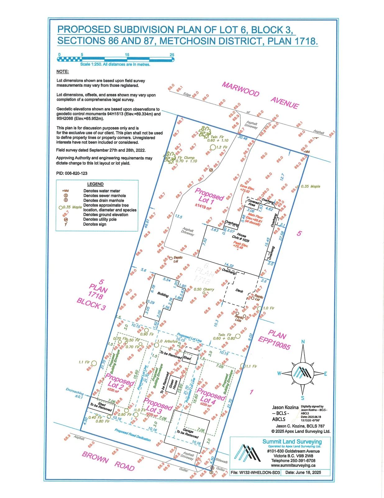
Survey/plan graphic showing the proposed subdivision layout for 1029 Marwood Avenue indicating three new lots fronting Brown Road and the retained remainder lot fronting Marwood Avenue.
Key facts
- Proposed plan shows three new lots accessed from Brown Road
- Includes 4.5 m road dedication along Brown Road
- Survey prepared by Summit/Apex Land Surveying (file referenced W132-WHELDON-SD3, date June 18, 2025)
Appendix A – Proposed Subdivision Plan (1029 Marwood Avenue)
PROPOSED SUBDIVISION PLAN
PROPOSED SUBDIVISION PLAN OF LOT 6, BLOCK 3,
SECTIONS 86 AND 87, METCHOSIN DISTRICT, PLAN 1718.
Scale
Scale 1:250. All distances are In metres.
Notes
- Lot dimensions shown are based upon field survey measurements may vary from those registered.
- Lot dimensions, offsets, and areas shown may vary upon completion of a comprehensive legal survey.
- Geodetic elevations shown are based upon observations to geodetic control monuments 94H1513 (Elev.=89.334m) and 95112066 (Elev.=65.952m).
- This plan is for discussion purposes only and is for the exclusive use of our client. This plan shall not be used to define property lines or property corners. Unregistered interests have not been included or considered.
- Field survey dated September 27th and 28th, 2022.
- Approving Authority and engineering requirements may dictate change to this lot layout or lot yield.
PID: 008-820-123
Legend
| Symbol | Meaning |
|---|---|
| +WM | Denotes water meter |
| ® | Denotes sewer manhole |
| OD | Denotes drain manhole |
| 00.35 moni,, | Denotes approximate tree location, diameter and species |
| (ground elevation symbol) | Denotes ground elevation |
| • | Denotes utility pole |
| (sign symbol) | Denotes sign |
Contact / Survey Company
Summit Land Surveying
A Operated by Apex Land surveying Ltd.
#101-830 Goldstream Avenue
Victoria B.C. V9B 2W8
Telephone 250-391-6708
www.summItsurveying.ca
File and Dates
File: W132-VVHELDON-SD3 | Date: June 18, 2025
Field / Surveyor Information
- Field survey dated: September 27th and 28th, 2022.
- Jason C. Kozina, BCLS 787
Selected plan callouts (as shown on plan)
- Twin Fir 0.60 + 1.10
- 01.2 Fir
- 0.35 Maple
- 0.50 Cherry
- 0.90 Fir
- 0.70 Fir
- 0.40 Fir
- 0.80 Fir
- 1.1 Fir
- 0.35 moni,, (approx. tree location/diameter/species)
(Note: Additional tree/species/diameter callouts and many numeric annotations appear on the plan image; the above are representative callouts transcribed from the page.)
Additional text on plan
- "Lot dimensions shown are based upon field survey measurements may vary from those registered."
- "This plan is for discussion purposes only and is for the exclusive use of our client. This plan shall not be used to define property lines or property corners. Unregistered interests have not been included or considered."
[Image 1 referenced above contains the full surveyed subdivision diagram with lot lines, tree callouts, utility symbols, dimensions, and geodetic annotations.]