DocumentsStaff ReportJan 24, 2022Pages 123–139
Application to Rezone 902 Walfred Road (RR5 to RS1) — 13-lot bare land strata
Staff report proposing rezoning of 902 Walfred Road from Rural Residential 5 (RR5) to Residential Small Lot 1 (RS1) to facilitate a 13-lot bare land strata subdivision, including required DCCs and amenity contributions.
Key facts
- Address: 902 Walfred Road
- Proposal: Rezone to RS1 for a 13-lot bare land strata subdivision
- Amenity contribution example: $600 (Small Lot) to Affordable Housing Fund per lot (condition noted)
- Conditions: Frontage improvements, service upgrades at applicant expense, stormwater management, and covenants
Application to Rezone 902 Walfred Road (RR5 to RS1) — 13-lot bare land strata
SITE AND SURROUNDING AREA
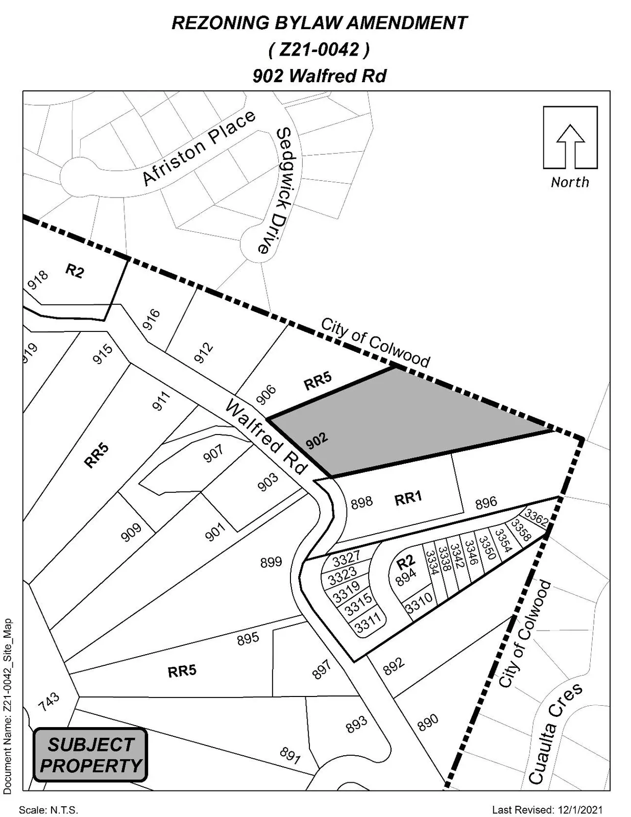
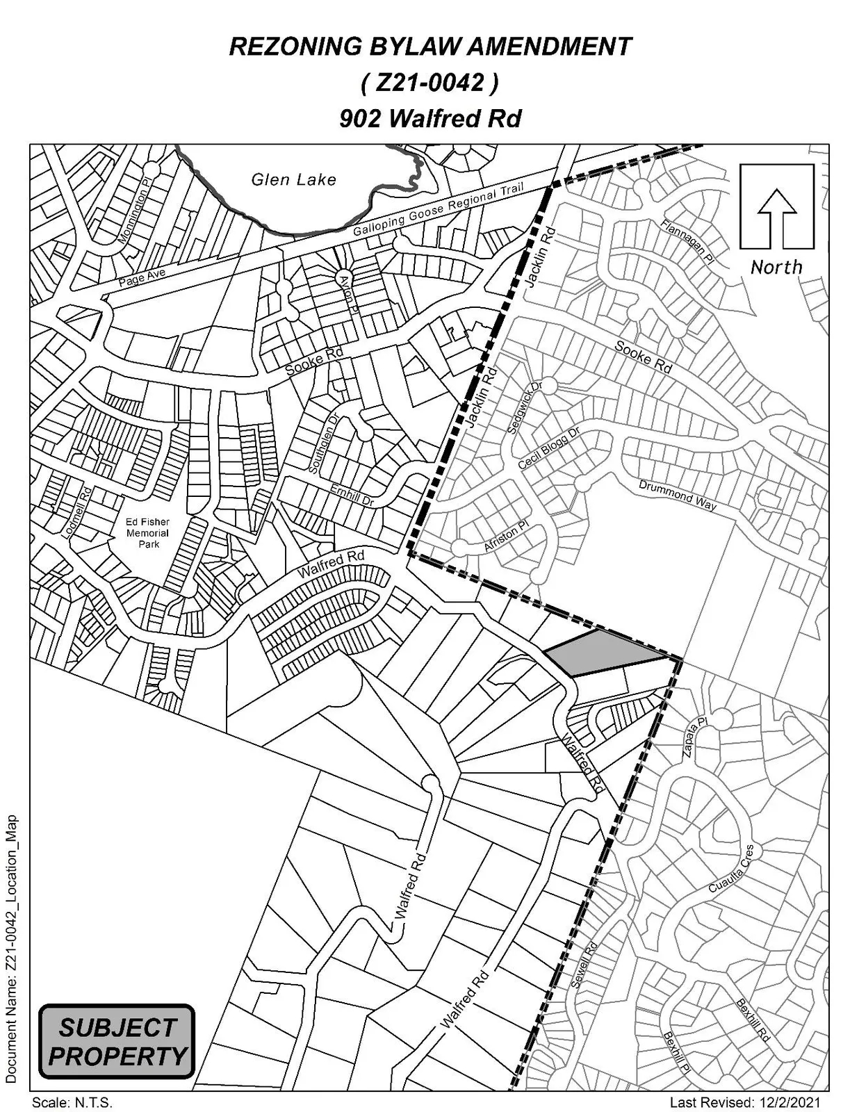
The subject property is located on the north side of Walfred Road, directly adjacent to the City of Colwood border. The site is heavily treed and the property slopes towards Walfred Road.
The surrounding properties are all primarily large lots zoned for rural residential use, and with similar topography and environmental conditions. It is noted that to the west, near Jacklin Road, there are various new small lot subdivisions that have been completed in the past several years. To the south-east, the property located at 894 Walfred Road was rezoned to RS4 (now R2) to allow a 15-lot subdivision. Construction works are underway on this site and sewer will be extended down Walfred Road, past the subject property, as part of the subdivision requirements. Further to the south-east, the property at 890 Walfred is currently under consideration of rezoning to the R2 Zone to allow an 8-lot subdivision.
Table 2: Surrounding Land Uses
| Zoning | Use |
|---|---|
| North | RR5 and City of Colwood — Rural Residential, heavily treed |
| East | RR1, R2 and City of Colwood — Rural Residential and One- and Two-Residential |
| South | RR1 and RR5 — Rural Residential |
| West | RR5 — Rural Residential |
COMMENTS
OFFICIAL COMMUNITY PLAN
The subject property is designated as Hillside or Shoreline within the Official Community Plan Bylaw No. 1200 as described below:
Hillside or Shoreline Predominantly existing low intensity settled areas throughout community with a high percentage of open space and undeveloped areas located on a hillside or near the shoreline.
- Predominantly residential precinct that supports a range of clustered low, medium and high density housing choices including secondary suites. Higher building forms, such as point towers, will be permitted on hillsides to maximize open space provided some conditions are satisfied (see policies for this area)
- Schools, community facilities and other institutional uses are permitted throughout the area
- Home-based businesses, live-work housing is encouraged; Home-based accommodations (e.g. Bed & Breakfasts) are permitted.
- Parks, open spaces and green corridors (creeks, wildlife corridors, trails, etc.) are integrated throughout the area. Large playfields are discouraged due to grading requirements. Site and topographic responsive pocket parks, enhanced viewpoints, graded hiking and walking trails, children’s play areas, including ‘tot lots’ and outdoor exercise areas are strongly encouraged on hillside areas.
- This area allows for Neighbourhood Centres to emerge in the form of high and medium density clustered mixed-use nodes
- Transit stops are located where appropriate
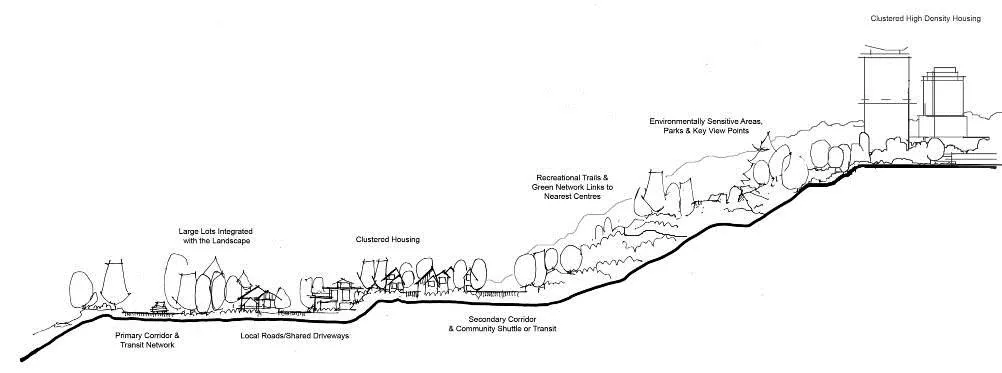
A Concept for Hillside or Shoreline Areas
DEVELOPMENT PERMIT AREAS
The subject property is located within the Potential Habitat and Biodiversity and Extreme Interface Fire Hazard Development Permit Areas. Reports prepared by registered professionals and a Development Permit will be required prior to the alteration of the land. The applicant has submitted a high-level overview of the habitat and biodiversity areas on site to confirm there are no immediate concerns about the proposed lot layout. A more detailed report will be required at the time of Development Permit. Additionally, Council designates any lots less than 550 m2 in area as small lots and therefore the proposed development would also require a Form and Character Development Permit pursuant to the Intensive Residential design guidelines.
DEVELOPMENT PROPOSAL
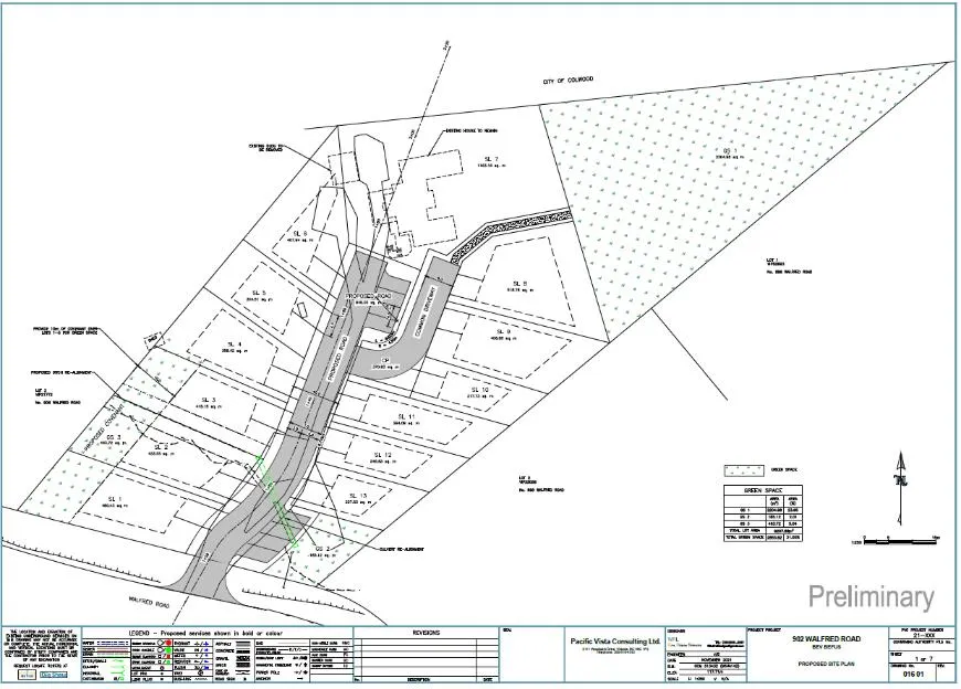
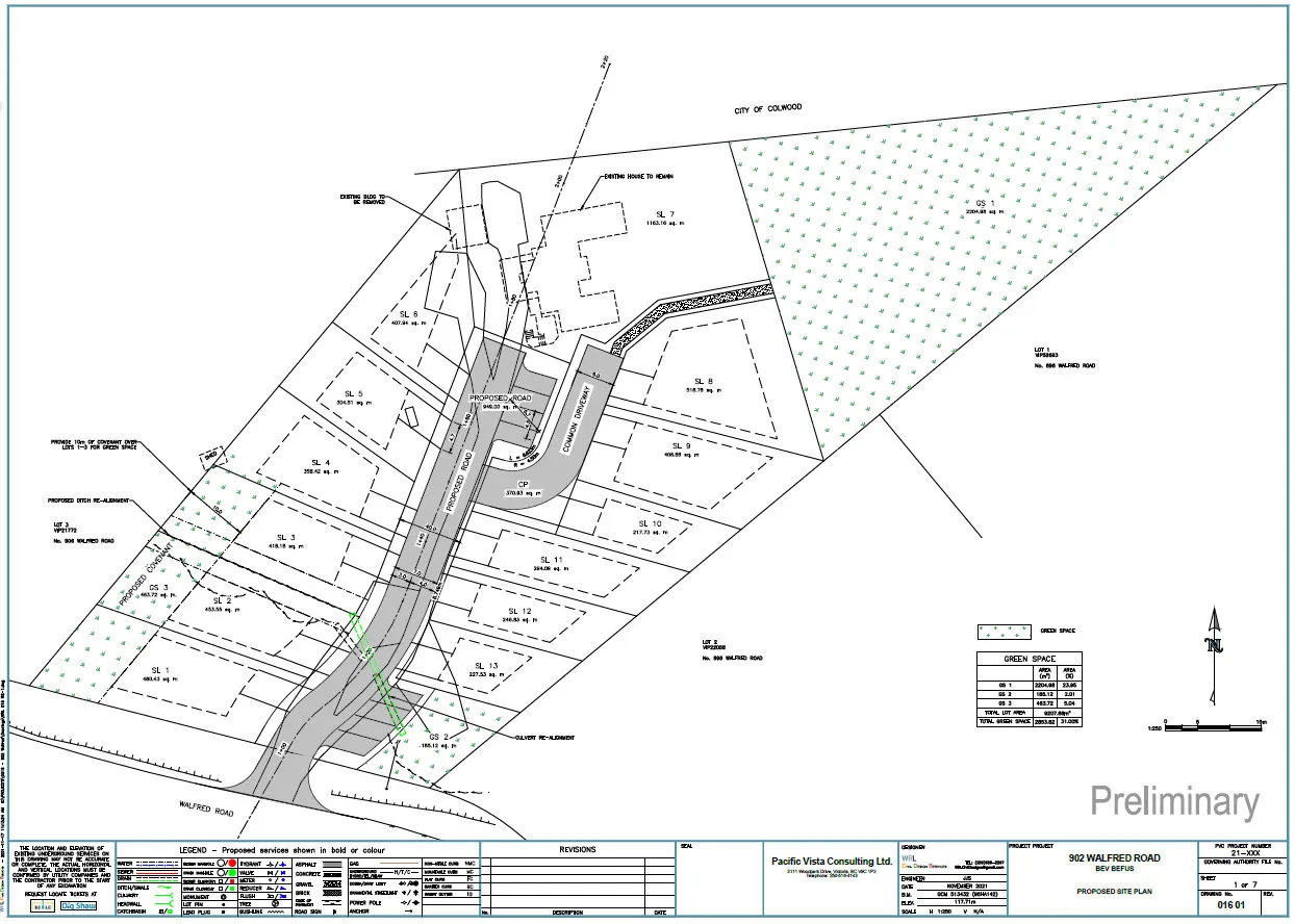
The applicant is proposing to rezone the subject property to RS1 (Residential Small Lot 1) to allow for a 13-lot bare land strata subdivision. The existing dwelling will remain. The size of the lots range between 217 m2 and 1163 m2, seven out of the thirteen lots would be eligible for a secondary suite as they exceed 400 m2. Each lot is required to have at least two parking spaces for the primary dwelling, and a third space is required for any lot that contains a secondary suite.
It is noted for reference that the average lot size, when considering the parent parcel size less the area of the strata road, is just over 600 m2. This is a lower density than the R2 Zone, but since some of the lots have lot areas and lot widths less than the R2 Zone, the applicant has requested the RS1 Zone.
As the applicant is intending to create 13 new lots, they will be required to create 7 on-street parking spaces as per Bylaw No. 1000 requirements. They have provided eight stalls and have demonstrated on their site plan where they intend for these spaces to be located.
The applicant has also provided a significant amount of undisturbed greenspace totaling 2,853 m2 or 31% of the site area. The proposed green space shall be registered as strata common property. Council may wish to require that the applicant register a non-disturbance covenant over these lands to ensure this greenspace is retained as proposed.
Table 3: Proposal Data
| Item | Permitted by RR5 (Current Zoning) | Permitted by RS1 (Proposed Zone) |
|---|---|---|
| Minimum Lot Size | 4,046.86 m2 (1 acre) | 200 m2 |
| Minimum Lot Width | n/a | 9 m |
| Maximum Height | 10.5 m (34.4 ft) | 9 m (29.5 ft.) |
| Maximum Site Coverage | n/a | 50% |
| Front Yard Setback | 7.5 m (24.6 ft) | 3 m (9.8 ft), and 5.5 m (18f ft) for garage portion |
| Interior Side Yard Setback | 3 m (9.8 ft) | 1.5 m (4.9 ft) |
| Exterior Side Yard Setback | 5.5 m (18 ft) | 3.5 m (9.8 ft), and 5.5 m (18f ft) for garage portion |
| Rear Yard Setback | 10 m (32.8 ft) | 5.5 m (18 ft) |
| Parking Requirement | 2 spaces per dwelling and 1 space for a secondary suite (if permitted) | 2 spaces per dwelling and 1 space for a secondary suite (if permitted) |
PARKS AND BOULEVARD
The Parks Department has indicated that vegetation within the road allowance on Walfred Road should be retained. If any vegetation is required to be removed, the applicant is required to replant the area and provide a temporary irrigation system from a private irrigation system, to be secured by way of a Section 219 Covenant.
The Parks Department has not requested that any park land be provided with this development. As such, in accordance with Section 510 of the Local Government Act, 5% cash-in-lieu of park land of the assessed value, following rezoning, would be required as a condition of subdivision approval.
INFRASTRUCTURE
Full frontage improvements in accordance with Bylaw No. 1000 and to the satisfaction of the Director of Engineering will be required as a condition of subdivision approval. Of note, the Engineering Department has indicated that the proposal will be required to provide streetlights, cash-in-lieu for a multi-use path and no on-street parking on Walfred Road.
STORMWATER MANAGEMENT
The applicant will be required to provide a stormwater management plan to the satisfaction of the Director of Engineering prior to subdivision approval or the issuance of a building permit, whichever is first. Council may wish to require a stormwater technical memo prepared by the project engineer prior to Public Hearing to verify that storm water can be adequately managed on-site for the proposed development.
FINANCIAL CONTRIBUTIONS
COUNCIL’S AFFORDABLE HOUSING, PARK AND AMENITY CONTRIBUTION POLICY
Rezoning the subject property may increase the assessed value of the property, and this may increase municipal revenue. As the applicant will be responsible for frontage improvements and connection to the municipal sewer system, the direct capital costs to the municipality associated with this development will be negligible. A summary of the Amenity Contributions and Development Cost Charges that the developer will be expected to pay is outlined below in Tables 4 and 5.
Table 4 – Amenity Contributions per Council Policy
| Amenity Item | Per unit contribution | Total (13 lots) |
|---|---|---|
| Affordable Housing Reserve Fund | $660 (Small Lot) $1,000 (Single Family – 550+ m2 lot) |
$7,920 (12 lots) $1,000 (1 lot) |
| General Amenity Reserve Fund | $3,960 (Small Lot) $6,000 (Single Family – 550+ m2) |
$47,520 (12 lots) $6,000 (1 lot) |
| TOTAL POLICY CONTRIBUTIONS | $62,440 |
Table 5 – Development Cost Charges
| Development Cost Charge | Per unit contribution | Total (12 lots) |
|---|---|---|
| Roads | $3,865 (Small Lot) $5,876 (300+ m2 lot) |
$34,785 (9 lots) $23,504 (4 lots) |
| Storm Drainage | $1,166 (Small Lot) $1,878 (300+ m2 lot) |
$10,494 (9 lots) $7,512 (4 lots) |
| Park Improvement | $1,890 | $24,570 |
| Park Acquisition | $1,100 | $14,300 |
| Incremental Storage Improvement Fees | $371.25 (Small Lot) $495 (400+ m2 lot) |
$2,227.50 (6 lots) $3,465 (7 lots) |
| Integrated Survey Area | $50 | $650 |
| Subtotal (DCCs paid to City of Langford) | $121,507.50 | |
| CRD Water | $2,922 | $37,986 |
| School Site Acquisition | $1,000 | $13,000 |
| TOTAL (estimate) DCCs | $172,493.50 |
OPTIONS
Option 1
THAT the Planning, Zoning and Affordable Housing Committee recommend that Council:
- Proceed with consideration of Bylaw No. 2030 to amend the zoning designation of 902 Walfred Road from the RR5 (Rural Residential 5) Zone to the RS1 (Residential Small Lot 1) Zone subject to the following terms and conditions:
a. That the applicant provides, as a bonus for increased density, the following contributions per lot prior to subdivision approval:
i. $600 (Small Lot) towards the Affordable Housing Fund;
ii. $1,000 (Single Family – 550 m2 or more) towards the Affordable Housing Fund;
iii. $3,960 (Small Lot) towards the General Amenity Fund; and
iv. $6,000 (Single Family – 550 m2 or more) towards the General Amenity Fund.
b. That, prior to Public Hearing, the applicant provides a technical memo from an engineer that verifies stormwater can be adequately managed on-site for the proposed developments, to the satisfaction of the Director of Engineer;
c. That the applicant provides, prior to Bylaw Adoption, a Section 219 covenant, registered in priority of all other charges on title, that agrees:
i. That the following will be provided and implemented to Bylaw No. 1000 standards to the satisfaction of the Director of Engineering prior to subdivision approval or the issuance of a building permit, whichever is first:
- Full frontage improvements; and
- A storm water management plan;
ii. That a Construction Parking and Traffic Management Plan be provided to the satisfaction of the Director of Engineering prior to any alteration of the land;
iii. That vegetation within the road allowance on Walfred Road should be retained. If any vegetation is removed, the applicant is required to replant the area and provide a temporary irrigation system from a private irrigation system to the satisfaction of the Manager of Parks
iv. That a non-disturbance covenant be registered over 31% of the land to be protected as open space on strata common property prior to subdivision approval, to the satisfaction of the Approving Officer;
OR Option 2
THAT the Planning, Zoning and Affordable Housing Committee recommend that Council:
Take no action at this time with respect to Bylaw No. 2030.
SUBMITTED BY
- Matt Notley, Planner I
Concurrence:
- Leah Stohmann, MCIP, RPP, Deputy Director of Planning and Subdivision
- Donna Petrie, Manager of Business Development and Events
- Matthew Baldwin, MCIP, RPP, Director of Planning and Subdivision
- Michelle Mahovlich, P.Eng, P.Geo, Director of Engineering and Public Works
- Michael Dillabaugh, CPA, CA, Director of Finance
- Marie Watmough, Acting Director of Corporate Services
- Darren Kiedyk, Chief Administrative Officer
APPENDICES
Appendix A – Proposed Site Plan
Appendix B – Site Map
Appendix C – Location Map
CITY OF LANGFORD — BYLAW NO. 2030
A BYLAW TO AMEND BYLAW NO. 300, “LANGFORD ZONING BYLAW, 1999"
The Council of the City of Langford, in open meeting assembled, hereby enacts as follows:
A. Langford Zoning Bylaw No. 300, 1999 is amended as follows:
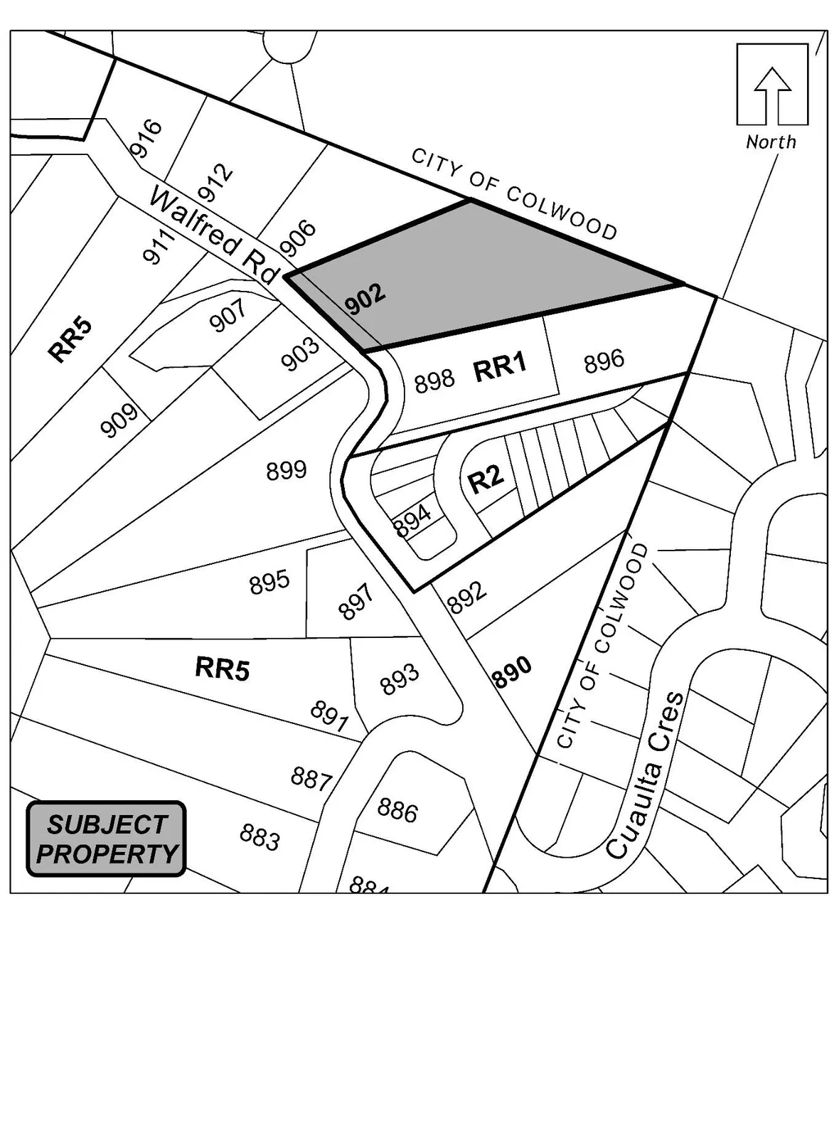
By deleting from the Rural Residential (RR5) Zone and adding to Residential Small Lot (RS1) Zone the property legally described as Lot 1, Section 78, Esquimalt District, Plan 22056, PID No. 003-297-411 (902 Walfred Road) in the portions as shown shaded on Plan No. 1 attached to and forming part of this Bylaw.
By adding the following to Table 1 of Schedule AD:
| Zone | Bylaw No. | Legal Description | Amenity Contributions | Eligible for Reduction in Section 2 of Schedule AD (Column 5) |
|---|---|---|---|---|
| RS1 | 2030 | Lot 1, Section 78, Esquimalt District, Plan 22056, PID No. 003-297-411 (902 Walfred Road) | a) $3,690 per lot less than 550 m2 towards the General Amenity Reserve Fund; b) $6,000 per lot 550 m2 or greater towards the General Amenity Reserve Fund; c) $660 per lot less than 550 m2 towards the Affordable Housing Reserve Fund; d) $1,000 per lot 550 m2 or greater towards the Affordable Housing Reserve Fund; |
No |
B. This Bylaw may be cited for all purposes as “Langford Zoning Bylaw, Amendment No. 655, (902 Walfred Road), Bylaw No. 2030, 2022".
READ A FIRST TIME this day of, 2022.
PUBLIC HEARING held this day of , 2022.
READ A SECOND TIME this day of , 2022.
READ A THIRD TIME this day of , 2022.
APPROVED BY THE MINISTRY OF TRANSPORTATION AND INFRASTRUCTURE this day of , 2022.
ADOPTED this day of , 2022.
PRESIDING COUNCIL MEMBER
CORPORATE OFFICER
Schedule A
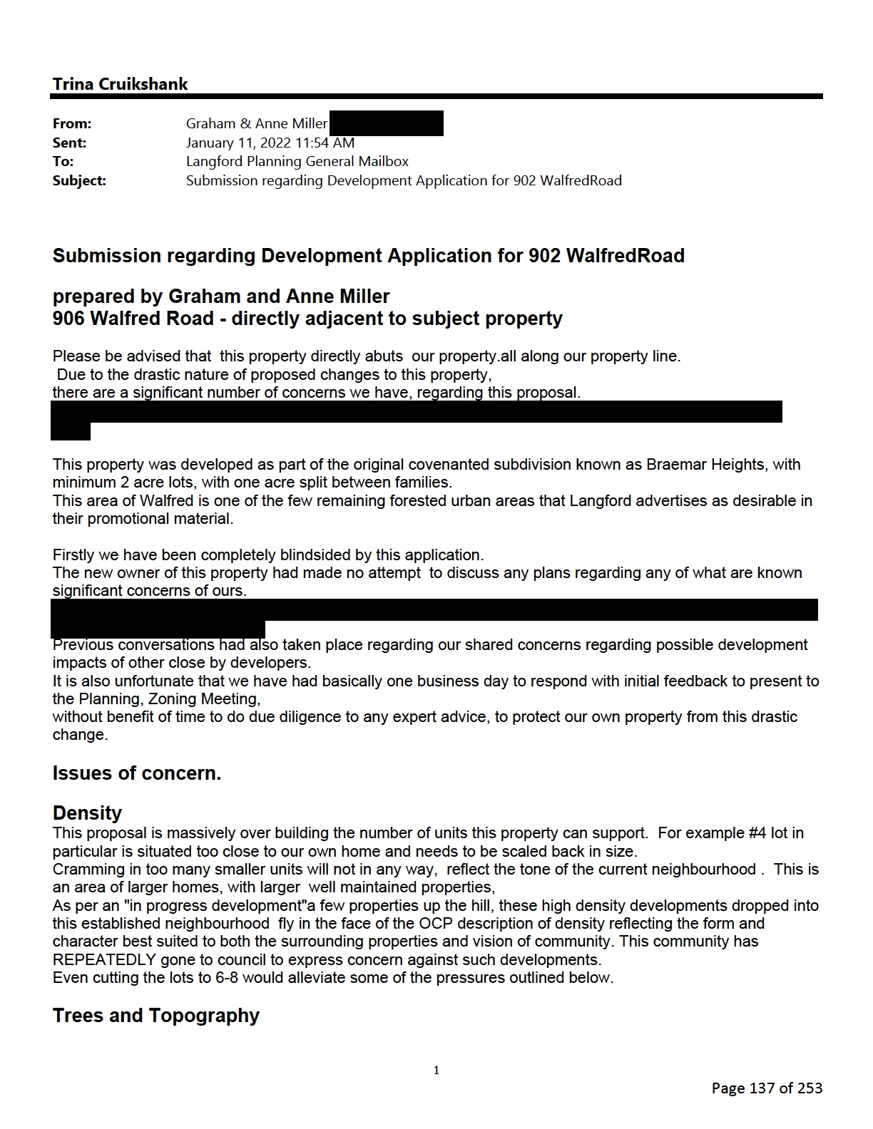
PUBLIC SUBMISSION: Graham and Anne Miller (906 Walfred Road)
At this time, this property is essentially a forest. This proposal will demand complete deforestation on the steepest slopes directly above and adjacent to our home which will destabilize the ground and cause a number of disruptions such as flooding, draining causing damage, destabilizing exisiting trees in our property,
Wind pattern
This abrupt deforestation will drastically interrupt the wind patterns of very tall and treasured trees left on what will be left of the forest on our property. These trees are directly beside our house. This will create potential for damage to our own home. Any approvals for developments that impact this issue will result in Langford being culpable for future damage to our property. We have not been furnished with any information regarding planning re trees
Slope
The topography is not reflected in this plan, being a very steep slope, which would entail massive amounts of fill being brought in. This will endanger our property. To level the ground for building will endanger our property and create a massive wall of what? This will directly impact our enjoyment of the most usable portion of our property, right adjacent to our dining room and deck area, which we basically spend half the year enjoying. What mitigation will be made to assure us any privacy with 6 homes looming over our yard?
How much fill and blasting will take place within yards of our living space? What impact will this have on our existing structure of our home? No information of grade level impacts as per page 143 of the OCP.
Water and flooding issues
Historically, due to topography, an existing natural waterway, development above us, over the years, this side of walfred has suffered considerable damage from poorly managed ground water disposal. Over the 45 years of this subdivision, homeowners, specifically 906 owner and 902 previous owner, over the years, having to mitigate by building a bridge and channel and culvert system to try to mitigate and manage the yearly rain and drainage from upper ditches.
No individual property owner should have to contend with having to privately manage the municipal drainage system. This has been repeated discussed and acknowledged by municipal staff on site after many flooding incidents. Recent work in the past two years has helped to mitigate this, but still is an ongoing issue as the rains yearly increase with global warming patterns changing. It has been acknowledged that more work is still needed to assist with current vulnerable spots above these properties. Riparian concerns and mitigations have not been shared with us as of this time, and we have had no time to pursue any response, due to the referred to tight timeline of this required feedback.
This proposed development will actually create an even larger flow directly through our property by straightening this water course. This is unacceptable and dangerous to our property. By removing the trees and proposed foundation work, the entire slope will destabilized and create a major hazard to our property. We look to the municipality to acknowledge and protect our home, as is our right to expect.. Langford must have a long record of the concerns of this portion of Walfred and should be referring to this history prior to beginning to discuss any size of the development.. We know that senior engineering and road staff have expressed concerns. As well, by having the extreme flow of water through that property, the sheer volume in the winter months create a safety hazard for any children living nearby, due to the shape creating a much more impactful flow.
OCP
We haven't even started to explain all the concerns that this development contravenes many sections of the OCP , for exqample, discussion of Urban forests page 159, Developmental impact of "mini watershed" areas, or the wildlife impacts and overall urban environmental impact of losing further greenspace. In fact this area of Walfred is not even recognized in map page 55 as greenspace. Many, many Langford residents question why there is even an OCP as it appears any change or variance tto this plan, hat is requested, is being approved despite the significant impacts to the environment, neighbourhoods and community.
We submit this feedback in the faint hope that Langford will endeavour to assist us to mitigate the massive changes this proposal will bring to our daily life in our home
Respectfully,
Graham and Anne Miller
906 Walfred Road
Langford, BC
V9C 2P4